
Satellogic is creating a live catalog of Earth and delivering daily updates to create a complete picture of the planet for decision makers in order for them to tackle some of the biggest challenges of these times. Satellogic uses Amazon Web Services (AWS) to scale their live Earth catalog, enhance customer experiences, decrease data processing times, and optimize costs.

“High-quality satellite data is critical to confronting some of the world’s most crucial issues, such as resource utilization and distribution,” said Matt Tirman, president of Satellogic North America. “For large-scale agriculture, our data can help answer questions about crop health, environmental impact, invasive pest lifecycles, drought, or flood risks. AWS is an accelerator and enables Satellogic to deliver insights and updates like these to customers sooner so they can prepare for and respond to change more effectively.”
Customers who rely on satellite data frequently have to make a trade-off decision: choose data that is current but not high-resolution, or opt for high-resolution imagery that is not as current. Traditional means of acquiring satellite data are expensive. This causes customers to make another difficult trade-off decision and prioritize either sticking to budgets or acquiring data critical to missions such as change monitoring on borders, assessing natural disaster damage, and updating marine and aviation applications.
Satellogic is focused on solving global challenges by making EO data more accessible and more affordable. Its vertically integrated business model, owning the design, manufacturing, and operation of its satellites, is what makes that mission possible. Satellogic’s lightweight, EO smallsats can be produced at scale with unrivaled unit economics. Satellogic now has 17 commercial satellites in LEO and plans to use AWS as they expand their constellation to more than 300 satellites by 2025.
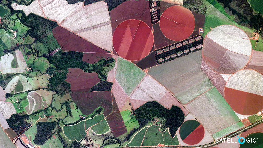
Satellogic’s current constellation can collect more than 5 million square kilometers of multispectral and hyperspectral imagery per day (that’s more than 4.8 billion hectares, or about the surface area of Russia). High-resolution multispectral data gives customers the ability to see vivid details like row crops, roads, buildings, and objects like ships, trucks, and aircraft. Hyperspectral imagery goes a step further and reveals spectral signatures of materials like metals and polymers—it can even identify vegetation species and detect moisture to assess crop health.
Each Satellogic satellite is now equipped to capture full-motion videos (FMV) up to 60 seconds in length and up to two minutes in the near future. This capability gives customers new opportunities to observe and archive short-term activity from the vantage point of space.
To help customers monitor change and respond rapidly to events, Satellogic provides as many as four daily revisits of any point of interest on Earth’s surface. Revisit rate is an essential capability for critical infrastructure monitoring and rapid response to any emerging event, be it a natural disaster or humanitarian crisis. It delivers a dynamic perspective of changing ground conditions which can be used to guide first responders as well as for recovery efforts.
To make the most of acquired EO data, the Satellogic Advanced Data Layers team leverages artificial intelligence (AI) techniques to help customers convert images into data layers via easy-to-use data services made available on the company’s online platform. Examples include object identification, classification, and semantic change detection as well as predictive models for a broad range of industries.

All of this generates massive volumes of data with each satellite generating an average of 50GB of data daily. For context, with a single 50 GB data plan, you can browse the internet for around 1,200 hours, stream 20,000 songs, or watch 200 hours of SD video. With a constellation roadmap that includes launching more than 300 satellites into orbit by 2025, Satellogic required a solution that could scale storage, processing, and delivery capabilities apace with each launch.
Satellogic uses Amazon Simple Storage Service (Amazon S3) and AWS global cloud infrastructure to enable customers to securely access petabytes of data on demand, paying only for the capacity they actually use. Satellogic leverages the multiple storage classes provided by AmazonS3 to optimize costs while making sure there is adequate availability and durability of the data. Processing the imagery requires vast amounts of compute power, for which Satellogic relies on AWS compute services such as Amazon Elastic Kubernetes Services (Amazon EKS) and AWS Lambda.
Amazon EKS enables Satellogic to run and manage Kubernetes applications in the cloud, benefiting from the flexibility of scaling clusters based on the load of their imagery processing pipelines. Satellogic uses Amazon EKS to reduce data processing times by an average of 20 to s30 percent. The processed data is made accessible to Satellogic customers through a serving layer built on top of Amazon CloudFront and Amazon API Gateway.
Amazon CloudFront brings the content closer to customer locations securely, which results in higher throughputs and lower latencies that are essential for the distribution of information at this scale. Amazon API Gateway makes it easy for Satellogic to create, publish, maintain and secure APIs to access the imagery products’ catalog, and the service scales to keep up with increases on demand.
“The collaboration between Satellogic and AWS can help increase sustainability across multiple industries, develop advanced applications, and improve emergency response at scale,” added Tirman. “By using AWS to store, process, and deliver data captured by its constellation of satellites, Satellogic enables customers to access daily global coverage of the Earth’s surface, a critical source of information for use cases such as emergency response, food security, global logistics, remote asset monitoring, among many others.”