• Skip to main content
  • Skip to primary sidebar
  • Home
  • News
  • Featured
  • More News ⌄
    • SatNews
    • SatMagazine
    • MilSatMagazine
  • Events ⌄
    • MilSat Symposium
    • SmallSat Symposium
    • Satellite Innovation
  • Contacts
  • SUBSCRIPTION

SmallSat News

You are here: Home / 2021 / Archives for September 2021

Archives for September 2021

HawkEye 360 Secures Contracts With The Potential Of Million$$ As Their Smallsats Become Fully Operational

September 30, 2021 by editorial

HawkEye 360 Inc. has secured new contracts totaling more than $50 million in potential value since the start of the year as the firm’s next generation satellites have become operational.

Artistic rendition of HawkEye 360’s Cluster 3 smallsats on-orbit. Image is courtesy of the company.

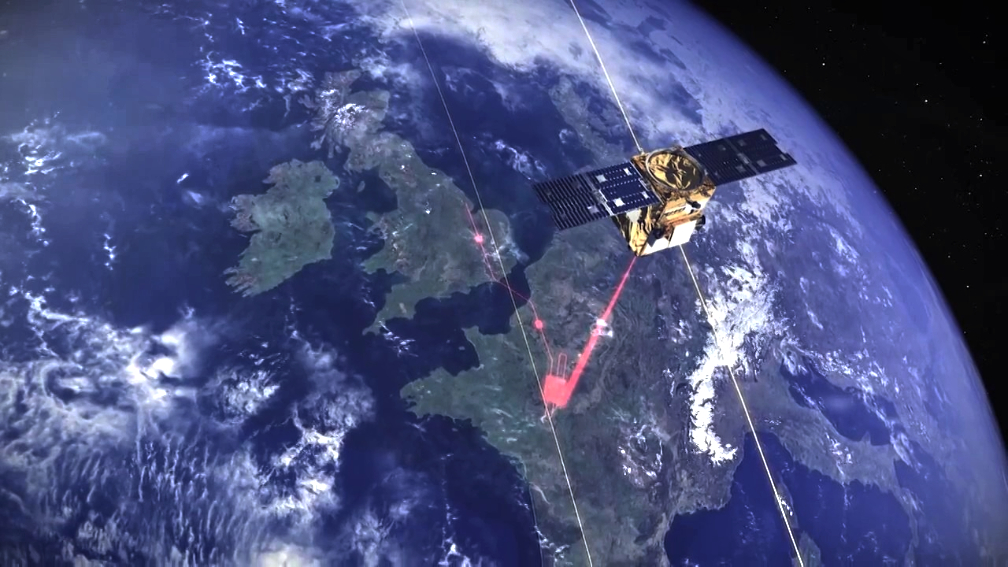
HawkEye 360 successfully launched three satellites (Cluster 2) in January, introduced the Mission Space platform for analysis of RF geospatial intelligence in February, and launched three more satellites (Cluster 3) in June. The next launch is planned no earlier than January 2022 and will carry six satellites (both Clusters 4 and 5) into orbit, simultaneously. The company has 15 additional satellites under production for launch to reach a total of 30 satellites on-orbit, with average global revisit around 30 minutes.

The company’s formation-flying satellites can detect, characterize as well as geolocate devices such as radars and push-to-talk radios, which improves visibility of human activity and patterns of life. This new data produces actionable insights for national defense and homeland security operations, maritime domain awareness, environmental protection and a growing number of commercial applications.

“HawkEye 360 is experiencing an exceptional year, with record growth in customer engagements and bookings,” said HawkEye 360 CEO John Serafini. “We’re building depth of customers across the United States, Americas, Europe, Middle East, and Asia, including transitioning from pilot programs into programs of record. We are rapidly launching satellites to have sufficient capacity to meet our rapidly growing backlog of customer demand. And our team has demonstrated resiliency even during the challenges posed by the coronavirus pandemic. The company has been doubling revenue each year and we expect this year to be no different.”

Filed Under: Featured, News

OrbAstro’s Smallsat Platform To Host Aistech Space’s Guardian Imaging Payload

September 30, 2021 by editorial

Aistech Space SL (Aistech) has signed a contract with Orbital Astronautics Ltd (OrbAstro) to fly the company’s first Guardian mission scheduled for launch in Q4 2021 onboard a SpaceX dedicated rideshare mission.

The OrbAstro ORB-6 satellite platform (6U-class) will host an Aistech multi-spectral imaging payload to commence commercial services addressing markets linked to environmental sustainability.

Aistech is planning to deploy a constellation of 20 thermal-enabled satellites. This will be one of the first commercial constellations able to collect high-resolution thermal infrared data on demand. Information captured by Aistech’s multi-spectral telescope will support decision-making in the public and private sector.

OrbAstro is highly vertically integrated, having built all subsystems and satellite platforms from the ground up. This has allowed the company to compress costs and lead-times substantially. Their ORB-class platforms specifically designed to address the constellation markets, are state-of-the-art, with Ultrascale+ and LPDDR4 based onboard computing, electric propulsion, full attitude determination and control system with dual star-trackers, S-band transceiver, and optical communications terminal as standard.

“Aistech is targeting a wide-open market and we are excited to see what they achieve. To meet surging demand from companies like Aistech Space, aspiring towards large constellations to provide their services, we at OrbAstro are scaling up our satellite production throughput,” said Dr. Ash Dove-Jay, CEO of OrbAstro. “Beyond this, the orbital data relay service we are building will add value to the Aistech constellation as it grows, by greatly reducing latency of the downlink of their imaging data.”

“Our mission is to work with organizations around the world to tackle critical threats to people and the environment, and build a better, more sustainable future for the next generation,” said Guillermo Valenzuela, CEO and Co-Founder of Aistech Space. “Our Guardian satellites will provide organizations with critical information for mitigating large-scale threats, such as forest fires, water waste, pollution, and illegal activity.”

Filed Under: News

Forrester’s Digest: OneWeb A “European Asset” / Nilesat 301 / Intelsat’s Document Deliveries

September 30, 2021 by editorial

Eutelsat’s CEO Rodolphe Belmer, in a meeting with a French parliamentary committee, told delegates that the OneWeb satellite consortium is now a “European asset” and that it was likely to be the only mega-constellation not owned by the US.

Eutelsat has a 17.5 per cent investment stake in OneWeb, with the British Government owing a similar amount. However, India and Japan are also major investors, as is Hanwha of South Korea.

Belmer told the parliamentarians that with the Eutelsat investment it meant that it was a very competitive asset in the low-latency world that is coming. He added that OneWeb would have priority satellite transmission rights, but also referred to Elon Musk’s Starlink and Telesat (of Canada) and its Lightspeed broadband by satellite service as likely to launch.

Moving on to the Egyptian Satellite Company, that firm is already serving some 56 million homes and 270 million viewers across the Middle East, North Africa and the Gulf regions. With the launch next year of Nilesat 301, it is intent on adding more homes and viewers from Africa.

“Being the mainstay satellite of the Arab world, Nilesat has always been present in each and every home, this fact has made an imperative commitment to deliver an unrivaled top-class service from our facilities in Cairo by the highest experienced team,” said CEO Ahmed Anis.

Nilesat’s existing fleet operates from 7 degrees West (while Eutelsat’s adjacent craft operate officially from the same positions, but with their own frequencies). There have been comments from Eutelsat which suggest that the close cooperation between Eutelsat and Nilesat might be coming to an end. Eutelsat’s upcoming results statement on October 27th might update the market on this relationship.

Nilesat 301 is due to be in position in Q2/2022 and will be launched on a Falcon 9 rocket from SpaceX. Nilesat 201, launched in August 2010, is still good for operations until 2028.

Artistic rendition of the Nilesat 301 on-orbit.

“We look into the future with many strategic partnerships among our fellow African countries, and for this Nilesat has built its vision towards its natural expansion in the sub-Saharan Africa with the new Nilesat 301 satellite. Nilesat 301’s design reflects the aim to introduce our services into the African market while upgrading our current and future services in the MENA region,” added Anis.

Key additional potential from Nilesat 301 includes “providing Ka-band over Egypt,” said the company, as well as adding extra capacity for high-definition broadcasts as well as 4K. The 301 will carry 6 Ka-band transponders (for broadband) and 32 Ku-transponders. Dedicated transponder beams will cover sub-Saharan Africa and also the Nile Basin of Ethiopia, Kenya, the Sudan, Tanzania, Somalia and the DR of Congo.

On to Intelsat… A large set of documents have been sent to all parties involved in the Chapter 11 bankruptcy reconstruction of the company.

Back on September 7th, the bankruptcy court handling Intelsat’s affairs issued an order that the Confirmation Hearing on Intelsat’s ‘Disclosure Statement’ and latest ‘Plan of Reorganization’ from bankruptcy will commence on November 8th.

The documents are contained in a USB flash drive sent to interested parties. The plan calls for a reduction of Intelsat’s debt burden from some $15 billion to about $7 billion. Some 75 percent of Intelsat’s debt-holders have already agreed to the debt reduction.

The main thrust of the documentation calls on all holders of financial claims to enter their ballot votes, accepting or objecting to the exit plan. Votes have to be filed by October 29th.

Meanwhile, on September 29th, the bankruptcy court will hear a Motion for the appointment of an Examiner (along with objections to the appointment). Intelsat says, in essence, the request is a last-ditch attempt to gain some leverage by equity holders who are expected to see little to nothing under the plan.

The sponsors of the Motion – who hold a modest 2 percent of Intelsat’s equity – say Intelsat has completely ignored valuable net operating losses and potential causes of action that it believes could provide some recoveries to shareholders.

An examiner is necessary to probe the full value of the company’s assets because it has so far been “ignored or devalued without explanation” in the plan, the group said in documents filed to the court.

Filed Under: Featured, News

Satellogic Reduces Data Processing Times For 300 On-Orbit EO Spacecraft Using AWS

September 30, 2021 by editorial

Satellogic is creating a live catalog of Earth and delivering daily updates to create a complete picture of the planet for decision makers in order for them to tackle some of the biggest challenges of these times. Satellogic uses Amazon Web Services (AWS) to scale their live Earth catalog, enhance customer experiences, decrease data processing times, and optimize costs.

“High-quality satellite data is critical to confronting some of the world’s most crucial issues, such as resource utilization and distribution,” said Matt Tirman, president of Satellogic North America. “For large-scale agriculture, our data can help answer questions about crop health, environmental impact, invasive pest lifecycles, drought, or flood risks. AWS is an accelerator and enables Satellogic to deliver insights and updates like these to customers sooner so they can prepare for and respond to change more effectively.”

Customers who rely on satellite data frequently have to make a trade-off decision: choose data that is current but not high-resolution, or opt for high-resolution imagery that is not as current. Traditional means of acquiring satellite data are expensive. This causes customers to make another difficult trade-off decision and prioritize either sticking to budgets or acquiring data critical to missions such as change monitoring on borders, assessing natural disaster damage, and updating marine and aviation applications.

Santa Juliana Minas Gerais, Brazil.

Satellogic is focused on solving global challenges by making EO data more accessible and more affordable. Its vertically integrated business model, owning the design, manufacturing, and operation of its satellites, is what makes that mission possible. Satellogic’s lightweight, EO smallsats can be produced at scale with unrivaled unit economics. Satellogic now has 17 commercial satellites in LEO and plans to use AWS as they expand their constellation to more than 300 satellites by 2025.

Satellogic’s current constellation can collect more than 5 million square kilometers of multispectral and hyperspectral imagery per day (that’s more than 4.8 billion hectares, or about the surface area of Russia). High-resolution multispectral data gives customers the ability to see vivid details like row crops, roads, buildings, and objects like ships, trucks, and aircraft. Hyperspectral imagery goes a step further and reveals spectral signatures of materials like metals and polymers—it can even identify vegetation species and detect moisture to assess crop health.

Each Satellogic satellite is now equipped to capture full-motion videos (FMV) up to 60 seconds in length and up to two minutes in the near future. This capability gives customers new opportunities to observe and archive short-term activity from the vantage point of space.

To help customers monitor change and respond rapidly to events, Satellogic provides as many as four daily revisits of any point of interest on Earth’s surface. Revisit rate is an essential capability for critical infrastructure monitoring and rapid response to any emerging event, be it a natural disaster or humanitarian crisis. It delivers a dynamic perspective of changing ground conditions which can be used to guide first responders as well as for recovery efforts.

To make the most of acquired EO data, the Satellogic Advanced Data Layers team leverages artificial intelligence (AI) techniques to help customers convert images into data layers via easy-to-use data services made available on the company’s online platform. Examples include object identification, classification, and semantic change detection as well as predictive models for a broad range of industries.

Satellogic’s self-service platform allows customers to view, stream, download, and task images. With on-demand access to high-resolution, high-frequency satellite imagery, processes can be streamlined to monitor change as well as run automatic queries globally and programmatically to gain a competitive advantage.

All of this generates massive volumes of data with each satellite generating an average of 50GB of data daily. For context, with a single 50 GB data plan, you can browse the internet for around 1,200 hours, stream 20,000 songs, or watch 200 hours of SD video. With a constellation roadmap that includes launching more than 300 satellites into orbit by 2025, Satellogic required a solution that could scale storage, processing, and delivery capabilities apace with each launch.

Satellogic uses Amazon Simple Storage Service (Amazon S3) and AWS global cloud infrastructure to enable customers to securely access petabytes of data on demand, paying only for the capacity they actually use. Satellogic leverages the multiple storage classes provided by AmazonS3 to optimize costs while making sure there is adequate availability and durability of the data. Processing the imagery requires vast amounts of compute power, for which Satellogic relies on AWS compute services such as Amazon Elastic Kubernetes Services (Amazon EKS) and AWS Lambda.

Amazon EKS enables Satellogic to run and manage Kubernetes applications in the cloud, benefiting from the flexibility of scaling clusters based on the load of their imagery processing pipelines. Satellogic uses Amazon EKS to reduce data processing times by an average of 20 to s30 percent. The processed data is made accessible to Satellogic customers through a serving layer built on top of Amazon CloudFront and Amazon API Gateway.

Amazon CloudFront brings the content closer to customer locations securely, which results in higher throughputs and lower latencies that are essential for the distribution of information at this scale. Amazon API Gateway makes it easy for Satellogic to create, publish, maintain and secure APIs to access the imagery products’ catalog, and the service scales to keep up with increases on demand.

“The collaboration between Satellogic and AWS can help increase sustainability across multiple industries, develop advanced applications, and improve emergency response at scale,” added Tirman. “By using AWS to store, process, and deliver data captured by its constellation of satellites, Satellogic enables customers to access daily global coverage of the Earth’s surface, a critical source of information for use cases such as emergency response, food security, global logistics, remote asset monitoring, among many others.”

Filed Under: News

Myriota Supercharges SatIoT Development With Their New Myriota Mouse™

September 30, 2021 by editorial

Myriota has announced the launch of their Myriota Mouse™
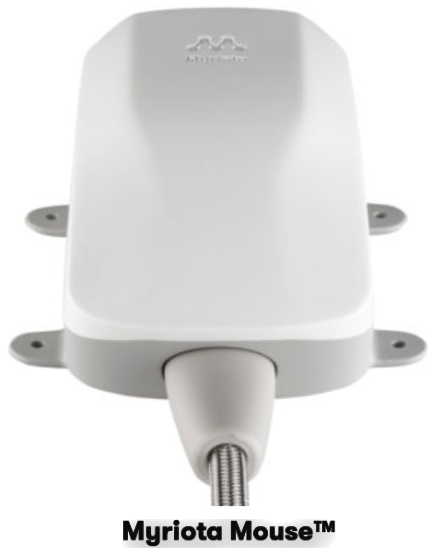
; a plug and play external antenna that is custom-built for satellite IoT applications.

IoT enables businesses to understand exactly where their assets are located, an essential requirement for industries such as transport and logistics, agriculture, environment, defense and utilities. Satellite connectivity is integral to enabling the successful communication of IoT devices, with many of these industry assets located in – or moving through – areas where traditional connectivity is intermittent or non-existent.

The Myriota Mouse™ provides high performance on the Myriota Network, and is manufactured to meet ingress protection (IP-65) and accelerated weathering (ASTM-G154) standards. The device has been developed in consultation with a panel of 25 Myriota customers that included Future Fleet and Ping Monitor, who are manufacturing Myriota-enabled products to connect critical industries, such as transport and logistics, utilities, environment and agriculture.

Myriota created the Myriota Mouse™ to help the firm’s diverse range of OEM Partners address their markets more quickly and to meet rising end-user demand, with 75 billion devices predicted to be connected to the internet globally by 2025. With the Myriota Mouse™, developers can easily integrate with the secure, ultra energy-efficient Myriota Module, and enable communication between on-ground assets and Myriota’s constellation of LEO smallsats.

Myriota CTO and co-founder, Dr. David Haley, said that the Myriota Mouse™ used the design thinking methodology; a human-centered, iterative process used by designers to tackle problems, leading to a strong end result that provides customers with a fast and accurate design cycle. “Until now, antennas were not designed to meet the needs of direct-to-orbit IoT applications, which is why Myriota, working closely with our OEM partners, has developed the Myriota Mouse™. The Myriota Mouse™ is a custom-built antenna for IoT that takes the guesswork out of design and quickly takes customers from idea to Myriota Network connectivity,” he said. “The device design and function has been validated by our valued Myriota Partners, with everything from product design to functionality and product testing being trialed.”

The launch of the Myriota Mouse™ comes after the business announced its partnership with Spire to expand their global satellite constellation and achieve near real-time connectivity by the close of 2022.

Filed Under: News

CesiumAstro’s On-Orbit Phased Array Experimental Satellites Enter Testing Phase

September 30, 2021 by editorial

CesiumAstro, Inc. successfully launched and deployed the first of their two satellites that feature their communications payloads aboard a United Launch Alliance Atlas V-401 rocket.

Dubbed Cesium Mission 1 (CM1), the duo of satellites will provide an on-orbit testbed for next generation wireless communications and sensing technologies.

The CesiumAstro team is conducting operations to complete direct ground-to-spacecraft communications over the company’s telemetry and control link. Initial system checkout and on-orbit commissioning will take up to one month to complete, after which payload operations will commence.

The satellites will run a multitude of experiments over the next several months, with CesiumAstro offering demonstration partnership opportunities to both commercial and government organizations interested in on-orbit evaluation of new algorithms, approaches and operational models using CesiumAstro’s communications payloads and onboard edge processing.

To follow Cesium Mission 1’s journey, please visit: www.cesiumastro.com/cesium-mission-01.

“We will see major advancements over the course of the next decade, which will revolutionize a highly-anticipated era of connected mobility,” said Shey Sabripour, Founder and Chief Executive Officer of CesiumAstro. “Our suite of core technologies is fully elevated through consistent and frequent testing as we initiate our first fleet deployments. Collaborating closely with the Defense Innovation Unit (DIU) and the Mission Manifest Office (MMO), among an alliance of distinguished launch partners, CesiumAstro is one step closer to transforming in-orbit and aircraft connectivity.”

“Our team did an incredible job moving from concept to orbit in under two years,” said Scott Carnahan, Cesium Mission 1 Manager. “We’re looking forward to building upon CM1 development and operations as we design and launch more advanced payloads.” T

Filed Under: News

Direct 2-Way, Sat-To-Mobile-Phone Comms Via Cell Towers In Space Are Proven Viable By Lynk Global

September 29, 2021 by editorial

Lynk Global, Inc. (Lynk) has registered hundreds of unmodified mobile phones to their 5th cell-tower-in-space in three different countries (UK, US and Bahamas). This critical milestone conclusively proves Lynk’s proprietary core satellite technology works with ordinary mobile phones on Earth, enabling broadband, voice and text messaging — from everywhere — with the phone in a user’s pocket.

Lynk’s 5th satellite (named “Shannon”), launched on June 30, 2021, has connected with, and registered, hundreds of mobile phones in initial tests, even in Virginia where Lynk connected in spite of the “noise” created by millions of mobile phones. Lynk has successfully repeated the tests in the United Kingdom, with testing permission from Ofcom, and in the Bahamas with the support of mobile network operator (MNO) partner Aliv. Lynk is the world’s only independently certified provider of cell-tower-in-space connectivity.

“Lynk has provided independent testing data that proves they are connecting existing Aliv devices that roam onto the Lynk system on areas outside the Aliv coverage footprint in the Bahamas,” said Dr. Stephen Curran, Aliv’s CTO. “The testing has proven the technology’s ability to simultaneously register and authenticate mobile devices. Lynk will provide a critical maritime communication service for our users. The Caribbean is also known for extreme weather events, and for earthquakes. Lynk will assist Aliv in providing emergency communications back-up when the network experiences major issues, and our sites are down.”

“Six years ago, the entire world thought it was impossible for a satellite to connect two-ways to existing mobile phones in use today,” says Charles Miller, Lynk’s CEO and co-founder. “Lynk has now done the impossible. We recently announced the first operators to sign up for our Flagship Carrier Program, Aliv in the Bahamas and Telecel Centrafique in the Central African Republic. These and others will launch commercial services in their countries in July 2022, beginning our journey to serve the unconnected around the world. Lynk is solving a problem that nobody else in the world is solving. We call it “The 0G Problem”. Next time you hear somebody use the phrase “5G”, ask yourself “How does 5G solve the World’s 0G problem? The answer … it doesn’t.”

“Lynk has solved the ‘Uplink Challenge’,” said Lynk CTO and co-founder, Tyghe Speidel. “Our 5th satellite has successfully completed it’s commissioning tests which includes our antenna and core mobile processing tests demonstrating the ability to receive and process signals from terrestrial subscriber phones on Earth that are out of terrestrial coverage. This is especially tough because of the noise from millions of other phones communicating terrestrially in the same mobile operator spectrum at the same time in our spot beam. We have repeatedly demonstrated the intricate two-way signaling required for a phone to connect to our cell tower in space, involving multiple instances of uplink and downlink messages, including a device request for channel access, and then the corresponding authentication and location update procedures. To date, we’ve done this with hundreds of phones in the UK, the Bahamas, and the US. This has never been proven before with a satellite cell tower and Lynk has done it. As part of the testing, we have also proven our signaling link budget (the signal power analysis) to close the link with existing mobile phones, as well as proven our ability to not interfere with existing terrestrial mobile operations while operating in the same bands.”

For more technical information, read How Lynk Proved Direct Two-way Satellite-to- Mobile-Phone Connectivity that explains what Lynk has accomplished with the hundreds of phone registration tests.

Lynk Global Inc. is a mobile technology company focused on providing universal connectivity for mobile phones and the world’s only independently verified space-based mobile network provider. The company’s patented technology allows standard mobile phones to be connected virtually anywhere via low-Earth-orbit satellites without any change to hardware or software. Headquartered in Falls Church, VA, Lynk’s leadership and engineering teams are experts in satellite engineering, space flight and policy, and wireless technologies.

Filed Under: News

AAC Clyde Space Strengthens Their Executive Team

September 29, 2021 by editorial

AAC Clyde Space has recruited Stefania Mandirola as Chief Operating Officer as part of a strengthening of the firm’s management team to meet the broader needs of the group that now spans six companies on three continents.

Stefania will take on the COO starting on October 6 to ensure operational efficiency as the Group continues to expand. In the last 12 months, AAC Clyde Space has acquired three companies in the United States, Netherlands and Sweden; set up a new space company in South Africa; and has experienced rapid, organic growth. To further support this development, Kulwinder Bhumbra will join the Group as HR Director in November.

Following these key additions, the executive management team has been reshaped, with Peter Anderson appointed the Chief Commercial Officer of the group and Dino Lorenzini becoming the Chief Scientific Officer of AAC Clyde Space.

Stefania joins AAC Clyde Space from Rolls-Royce Aerospace where she has held various leadership positions, most recently as Head of Supplier Management. She holds a Master of Science from Politecnico di Milano.

“I am thrilled to have joined AAC Clyde Space at a such pivotal time of growth and I am looking forward to leading their group operations globally. Space is an extremely exciting sector right now: satellites data and services have the potential to address some of the critical sustainability challenges of our times. Space is awesome,” saidStefania Mandirola.

Kulwinder joins from Volvo and brings more than 10 years’ experience in HR roles and has worked through a variety of change initiatives.

These latest appointments follow Dr. Andrew Carrel joining the Group in May 2021 from a position as CTO of Rezatec, a specialist company in geospatial analytics. He has worked in the space industry for over 20 years.

The executive management team will now consist of CEO Luis Gomes, CFO Mats Thideman, COO Stefania Mandirola, CTO Andrew Strain, CCO Peter Andersson, Vice President of Future Programs Andrew Carrel, HR Director Kulwinder Bhumbra as well as the Chief Scientific Officer, Dino Lorenzini.

“AAC Clyde Space has grown aggressively during the past year and aims to continue to do so. By adding further expertise from successful high-tech companies, we strengthen our prospects for success and can aim even higher. I look forward to working together with the new executive management team to reach ambitious goals,” said AAC Clyde Space CEO, Luis Gomes.

AAC Clyde Space is targeting a turnover of 500 MSEK (Million Swedish Kroner) in 2024. In its report for the first half of 2021, the Group reported sales of 84.2 MSEK and an orderbook of 413 MSEK.

Filed Under: News

Blending Competencies Are TXMission + Arralis Technologies For Comm Products

September 29, 2021 by editorial

TXMission has signed a technology, sales and distribution agreement with Arralis Technologies Ltd., a leading, advanced millimeter-wave communications solution provider.

The companies will jointly develop a suite of communication products for smallsat, HAPS, UAV and airborne applications that require high-performance and extremely low size, weight and power. Development will initially focus on a range of advanced Ka-band transceivers with integrated gigabit Software Defined Radios (SDRs), satellite terminals, phased array antennas and network management systems.

Steve McHugh, Chairman of TXMission, said, “This is another exciting collaboration that combines our unique SDR technology with Arralis’ outstanding RF capabilities, allowing us to provide a range of complete advanced satellite and airborne communications systems.”

Mike Gleaves, CEO of Arralis, said, “This is excellent news for satellite integrators seeking a high data rate communications platform. This strategic partnership enables a one-stop risk-free route to implementation, with minimum required expertise and maximum benefits.”

TXMission is a New Space company that provides advanced Software Defined Radios (SDRs), compatible ground equipment and network management systems for the smallsat, HAPS, UAV and airborne communications markets.

Arralis provides world leading expertise in RF, micro and millimeter-wave technology. Arralis excels in Monolithic Microwave Integrated Circuits (MMICs), packaged component modules, proprietary antenna technology and integrated radar and communications front-end platforms that provide high data rate wireless communications. Arralis products are used in both global and space environments where accuracy and reliability are critical. Arralis works with some of the world’s largest aerospace, automotive, defence and communications companies.

Filed Under: News

UPDATE: NASA’s Landsat 9 Mission Successfully Launched By ULA From Vandenberg Space Force Base

September 27, 2021 by editorial

A United Launch Alliance (ULA) Atlas V rocket lifts off at 11:12 a.m. from Vandenberg Space Force Base on September 27, 2021, carrying NASA’s Landsat 9 and multiple smallsat payloads to orbit.

ULA’s Atlas V rocket on the launch pad awaiting the countdown.

Atlas V accelerated using 860,000 pounds of thrust while performing the pitch and yaw maneuvers off the launch pad to obtain the proper heading, en route to a near-polar, sun-synchronous orbit to deploy Landsat 9.

Original information…

The launch is on track for September 27 from Space Launch Complex-3 at Vandenberg Space Force Base. Launch is planned for 11:11 a.m. PDT. The live launch broadcast starts at 10:30 a.m. PDT on September 27 at www.ulalaunch.com.

Landsat 9 is a joint mission of NASA and the U.S. Geological Survey (USGS). In addition to Landsat 9, this mission includes the ESPA Flight System (EFS) that will deploy multiple cubesats after Landsat 9 separation. The Atlas V will deploy the Landsat 9 and the smallsats into two different orbits, enabling the first, four-burn, Centaur mission for ULA on an Atlas V rocket. The Centaur upper stage has the capacity for increased performance, and the flight design of the Landsat 9 mission takes advantage of that capability.

The mission will launch on an Atlas V 401 configuration rocket that includes a 13.7 ft. (4 meters) Extra Extended Payload Fairing (XEPF) and stands 194 ft. (59 meters) tall. The Atlas booster for this mission is powered by the RD AMROSS RD-180 engine. Aerojet Rocketdyne provided the RL10C-1 engine for the Centaur upper stage.

The Russian-built RD AMROSS RD-180 engine for Atlas V.

This will be the 88th launch of the Atlas V rocket and 20th mission launched on an Atlas V in partnership with NASA’s Launch Services Program (LSP). This launch is the 300th Atlas launch from Vandenberg Space Force Base. To date, ULA has launched 144 times with 100 percent mission success.

“We are proud to continue to serve as the primary launch provider for Landsat missions. ULA and our heritage launch vehicles have launched every Landsat mission since 1972,” said Gary Wentz, ULA vice president of Government and Commercial Programs. “The Landsat series provides outstanding data for Earth environment and science-based research and Landsat 9 will add to these capabilities. We have worked alongside our partners, in a challenging health environment, to prepare to launch this important mission that will empower Earth research from space for decades to come.”

Filed Under: News

  • Go to page 1
  • Go to page 2
  • Go to page 3
  • Interim pages omitted …
  • Go to page 6
  • Go to Next Page »

Primary Sidebar

WEEKLY NEWSLETTER

Archives

  • February 2023
  • January 2023
  • December 2022
  • November 2022
  • October 2022
  • September 2022
  • August 2022
  • July 2022
  • June 2022
  • May 2022
  • April 2022
  • March 2022
  • February 2022
  • January 2022
  • December 2021
  • November 2021
  • October 2021
  • September 2021
  • August 2021
  • July 2021
  • June 2021
  • May 2021
  • April 2021
  • March 2021
  • February 2021
  • January 2021
  • December 2020
  • November 2020
  • October 2020
  • September 2020
  • August 2020
  • July 2020
  • June 2020
  • May 2020
  • April 2020
  • March 2020
  • February 2020
  • January 2020
  • December 2019
  • November 2019
  • October 2019

© 2019–2023 SatNews

x
Sign Up Now!

Enjoy a free weekly newsletter with recent headlines from the global SmallSat industry.

Invalid email address
We promise not to spam you. You can unsubscribe at any time.
Thanks for subscribing! You will now receive weekly SmallSat News updates.
We love our advertisers.
And you will too!

Please disable Ad Blocker to continue... We promise to keep it unobtrusive.
We promise not to spam you. You can unsubscribe at any time.
Invalid email address
Thanks for subscribing! Please check your email for further instructions.