UP42, a geospatial developer platform and marketplace, and OroraTech, a leader in space-based thermal intelligence, have signed a partnership agreement to grant easy and fast access to global, high-resolution, thermal-infrared imagery — OroraTech delivers low-latency, global coverage, near-real-time thermal data products.
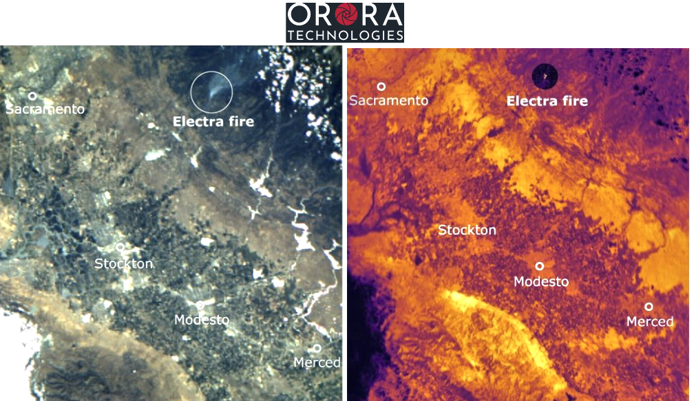
OroraTech, the first of its kind to join UP42’s growing marketplace of nearly 80 data and processing partners, provides valuable insights to customers during unpredictable events through its newly launched thermal sensor, FOREST-2. Via UP42’s marketplace, the company offers the following data products:
- On-demand tasking for near real-time data access from anywhere in the world with 400 km coverage and 200 m resolution on a daily basis.
- Access to an ever-growing future archive of thermal imagery for past event analysis.
UP42 tasking allows for advanced capabilities such as order tracking, automated delivery, and support for complex and multi-geometry Automated Optical Inspection (AOIs). Furthermore, OroraTech’s tasked data is managed in UP42’s STAC-compatible storage, simplifying the search and management of data for easier processing and integrations.
OroraTech’s high-resolution thermal data serves customers on six continents, ranging from forestry and utility companies to governmental organizations and geospatial experts. Facilitating rapid disaster response, location accuracy, and predictive analytics, its data helps assess risks, minimize losses, and supports 24/7 response measures.
“As global temperatures rise, wildfires and heat waves are having an increasing impact on people, the environment, and economies. In 2022 alone, heat waves accounted for 99% of all climate-related deaths in Europe. Expanding our offering with OroraTech’s thermal-infrared data will help our customers build early-warning and monitoring systems to help us mitigate the impact of these climate-related emergencies.” — Sean Wiid, CEO of UP42
“With UP42 our customers have easy and quick access to our thermal tasking capability. This partnership accelerates our route to the geospatial market.” — Axel Roenneke, CCO at OroraTe
UP42 was founded in 2019 with a clear purpose: to provide quick and easy access to geospatial data and analytics. You’ll get the world’s leading providers of optical, radar, elevation, and aerial data, all in one place. Our developer-first platform offers flexible APIs and a Python SDK to help you build and scale your solutions. Search the catalog for existing imagery, or task a satellite to capture your desired area. Whatever your use case, UP42 is the one-stop-shop for all your geospatial data needs.
OroraTech is a global intelligence-as-a-service company leveraging thermal data for a sustainable Earth. Their product, Wildfire Solution, powered by high-resolution thermal data from our proprietary space-based sensor system, is trusted worldwide for revolutionizing wildfire detection. Since 2022, OroraTech has established a comprehensive global monitoring network, delivering real-time situational awareness and prompt risk alerts. The cutting-edge system detects fires of any scale, day or night, ensuring timely action. Founded in 2018, OroraTech is headquartered in Munich, Germany, with operations in Canada and Brazil. With a dedicated team of 90 experts, OroraTech is committed to delivering innovative solutions for a sustainable future.