• Skip to main content
  • Skip to primary sidebar
  • Home
  • News
  • Featured
  • More News ⌄
    • SatNews
    • SatMagazine
    • MilSatMagazine
  • Events ⌄
    • MilSat Symposium
    • SmallSat Symposium
    • Satellite Innovation
  • Contacts
  • SUBSCRIPTION

SmallSat News

You are here: Home / Archives for 2022

Archives for 2022

RUAG Space + Stream Analyze Connect Together To Enable AI On Satellites

January 25, 2022 by editorial

Swarms of hundreds or thousands of smallsats are increasingly used for bringing data and internet services to Earth. To position, communicate and dispose such large amounts of satellites, Artificial Intelligence (AI) is getting increasingly important. To enable a large-scale use of AI on-orbit, RUAG Space and Stream Analyze are teaming up.

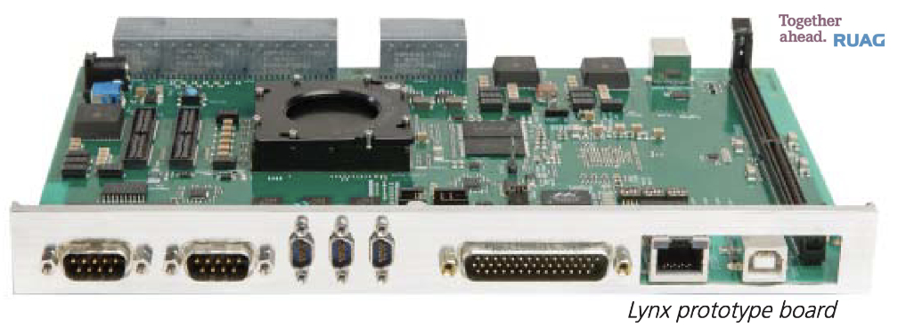
They have agreed to combine RUAG Space’s latest single board computer for satellites called “Lynx,” with Stream Analyze’ analytics platform “sa.engine,” to provide solutions for space customers’ future AI applications in space. A “smart” satellite will be able to automatically send messages to Earth of its own performance and status, such as: “Hello, it seems like I am going to use 20% more energy than usual next week. Is that ok?” instead of just raw data.

With large new constellations of satellites (satellite swarms) forming a large mesh of interconnected nodes in a constantly moving dynamic global network, it is a huge challenge to orchestrate the communication traffic in an optimal way. Analyzing the network behavior, such as traffic patterns or other characteristics in a software defined satellite dynamic communication network, allows for optimizing data routes through the network and hence the performance of the complete communication system. Stream Analyze’ sa.engine allows this network optimization to be performed in real-time onboard the satellite.

Through Stream Analyze’ analytics platform sa.engine the operator of the satellite will be able to interact directly with the satellite’s sensors and query any kind of questions. The sa.engine itself requires only a few megabytes and is hardware and software independent, so it can be integrated into the complete standard portfolio of RUAG Space’s on-board computers and into almost any other satellite computer. As sa.engine is scalable, it will be able to support any fleet of satellites and to interact with and learn from other satellites.

“This cooperation makes satellites ready for intensified use in future of Artificial Intelligence,” said Anders Linder, Senior Vice President Satellites at RUAG Space. Moving the intelligence from servers on ground into edge processing on the satellite in space has several advantages, Anders Linder added, “It is possible to optimize response times and utilization of the data downlink resource which is often a bottleneck. Especially as sensors are getting more powerful and producing more and more data in the satellites which would currently need to be sent to Earth for processing.”

“For us at Stream Analyze to add value and new capabilities to others through edge analytics is what we are all about. An example of such a new capability will be for others to analyze the data provided by the satellite sensors on the fly, as it is produced and without latency, allowing for faster response times and decisions,” said Nils Sahlberg, Vice President and Head of Strategy and Business Development at Stream Analyze. “Decision support can be downlinked to ground much quicker than with a complete data set. It is also possible to make the decisions autonomously directly on the satellite. Data can be analyzed on board the satellite to make decisions in real-time by combining different sensor inputs. Monitoring data related to the satellite itself will also enable a more optimized satellite operation, performance and lifetime.”

The development of analytics algorithms is both time consuming and has limited capability to be changed after launch. “With the sa.engine at hand, one doesn’t need to finalize the algorithms and the satellite capabilities before launch. You can literally develop and deploy as you go – changing the model development process and the satellite operations fundamentally – generating a better, more adaptable, and cheaper operation,” said Jan Nilsson, CEO at Stream Analyze.

Stream Analyze provides a groundbreaking software engine that enables an interactive deployment of analytics and local smartness on any device. It becomes a tool in the hands of people in the whole organization, allowing them to change the way they do business, forever. Based on over 30 years of research, the company was founded in 2015 in Uppsala, and was recognized as one of Sweden’s leading tech start-ups in 2021.

RUAG Space is a leading supplier to the space industry in Europe and has a growing presence in the United States. Around 1,300 employees across six countries (Switzerland, Sweden, Austria, Germany, USA and Finland) develop and manufacture products for satellites and launch vehicles—for both the institutional and commercial space market. RUAG Space is part of RUAG International. The Lynx computers are being designed and built at RUAG Space’s site in Gothenburg, Sweden.

Filed Under: News

Partnership Between Spire Global + Dragonfly Aerospace Will Support The Australian Office of National Intelligence

January 25, 2022 by editorial

Spire Global, Inc. (NYSE: SPIR) is now engaged in a partnership with Dragonfly Aerospace to support the Australian Government’s Office of National Intelligence (ONI) with a second satellite as a part of its ongoing National Intelligence Community Satellite (NICSAT) program.

The follow-up program, NICSAT2, will witness Spire designing, building, and launching the company’s Low Earth Multi-Use Receiver (LEMUR), a 6U smallsat platform, with the capability of on-board computing and processing of machine learning and artificial intelligence across multi-modal data. Dragonfly Aerospace will provide a high-performance Gecko camera using its proprietary space-proven electronics and ruggedized optics for an easy-to-integrate imaging solution for the satellite.

The Australian National Intelligence Community (NIC) launched the NICSAT program to experiment with commercial satellite technologies, including the on-board application of advanced machine learning capabilities on smallsats, such as those manufactured by Spire. In keeping with its predecessor, NICSAT2 will be managed by ONI and focused on the application and use of miniaturized satellite systems, especially in regard to machine learning. Both programs are unclassified science and technology programs, focused on innovative engineering and research that aim to utilize commercial satellites to improve data collection and analysis.

With the large influx of data sent to Earth, corporations, governments, and other organizations increasingly need advanced systems and processes to efficiently understand the data received. Artificial Intelligence (AI)-assisted processing within satellites allows operators to unburden ground stations and other infrastructure and focus resources on analyzing mission-critical information in space. ONI recognizes the potential application of semi-supervised or unsupervised learning methods for in orbit autonomous machine learning to, amongst other things, enable autonomous sensor operations, speed analytics and data processing, reduce downlink requirements, and better enable human analysts.

Spire previously worked on the NICSAT program’s first satellite, Djara, last year. The mission focus of Djara is to conduct experiments with systems that enable the on-orbit collection and analysis of data including commercially available sensors and technologies such as Field Programmable Gate Arrays (FPGAs) and Machine Learning (ML) systems on a chip. The satellite went from concept to launch in just six months and to full operation in just nine months. Djara collects and processes data on orbit and then leverages Spire’s cloud infrastructure to downlink, further process, and analyze data.

NICSAT2 was successfully launched aboard the SpaceX Transporter-3 mission on January 13th, 2022.

“The success of Djara and the NICSAT program show the significant value of small satellites for rapid deployment of leading-edge innovations and on-orbit data analysis,” said Theresa Condor, Chief Operating Officer at Spire Global. “With our continued work on NICSAT2, Spire and Dragonfly Aerospace reaffirm the importance of public-private partnerships for dual-use space technologies.”

“Dragonfly Aerospace’s Gecko camera will elevate the satellite’s imaging capabilities and improve the image quality sent back to the ONI,” said Bryan Dean, CEO of Dragonfly Aerospace. “Spire’s proven success with NICSAT made them an ideal partner to continue to support the Australian government and we look forward to working together.”

Spire (NYSE: SPIR) is a global provider of space-based data, analytics, and space services, offering access to unique datasets and powerful insights about Earth from the ultimate vantage point so that organizations can make decisions with confidence, accuracy, and speed. Spire uses one of the world’s largest multi-purpose satellite constellations to source hard to acquire, valuable data and enriches it with predictive solutions. Spire then provides this data as a subscription to organizations around the world so they can improve business operations, decrease their environmental footprint, deploy resources for growth and competitive advantage, and mitigate risk. Spire gives commercial and government organizations the competitive advantage they seek to innovate and solve some of the world’s toughest problems with insights from space. Spire has offices in San Francisco, Boulder, Washington DC, Ontario, Glasgow, Luxembourg, and Singapore.

Dragonfly Aerospace designs and builds compact high-performance imaging payloads and microsatellites which enable large imaging constellations that provide persistent views of the Earth in a wide range of spectrums giving unprecedented business intelligence and improving the lives of people around the world. Dragonfly Aerospace satellites and payloads are based on a 25-year heritage of components and design approach dating back to the first South African smallsat, SUNSAT, launched in 1999. Members of our team have worked on every microsatellite space mission since South Africa entered the space race more than 40 years ago.

Filed Under: News

Orbital Micro Systems Selected For Elite U.S. Defense Exportability Features Program

January 25, 2022 by editorial

Orbital Micro Systems’ (OMS) Global Earth Monitoring System (GEMS), WeatherRecord, WeatherLock, and International Center for Earth Data (ICED) capabilities, have been competitively selected across the entire Department of Defense (DoD) after nomination by the U.S. Space Force (USSF) to the Office of the Secretary of Defense’s Defense Exportability Features (DEF) program.

The DEF program is designed to develop and incorporate technology protection features into designated systems during their research and development phases with the goals of enhancing coalition interoperability, decreasing costs to the DoD and partner nations, and improving the international competitiveness of U.S. defense systems.

Through this initiative, OMS will perform market research for the DoD regarding the potential to export its technology portfolio to countries who have signed defense cooperation treaties or agreements with the United States, including the Combined Maritime Forces, Organization of American States, North Atlantic Treaty Organization (NATO), Five Eyes, Five Power Defense Arrangement, ANZUS treaty, Compact of Free Association, U.S.-Israel Strategic Partnership, Japanese Security Alliance, South Korea Mutual Defense Agreement, India Major Defense Partner, and Rio treaty. In addition, OMS will outline a plan to incorporate the necessary program protection and security features to enable future export of its capabilities.

In its nomination for the DEF program, the USSF noted that the OMS technology portfolio has a high degree of potential for export to international government customers who lack in-country Meteorological Satellite (MetSat) and Meteorological Data (MetData) capabilities.

“OMS is truly humbled to be selected for the highly competitive DEF program and is working quickly to engage with 20 U.S. government stakeholder organizations to coordinate this complex effort, including the Space Force, U.S. Air Force, U.S. Navy, and National Oceanic and Atmospheric Administration (NOAA),” said Michael Hurowitz, OMS chief executive officer. “Our unique passive microwave satellites (GEMS), data platform (ICED), WeatherRecord nowcasting, and WeatherLock forecasting systems enable continuous monitoring of and rapid access to environmental data to inform mission critical decisions. Our suite of technologies can cost-effectively deliver MetSat and MetData capabilities to countries without their own space-based weather observation infrastructure.”

Orbital Micro Systems (OMS) specializes in the development and delivery of remote sensing technologies for space, air, sea, and land applications. With broad expertise in applied science, weather science and Earth observation, instrumentation development, data science, space operations, and program delivery, OMS is positioned to deliver innovation to many markets, including insurance, transportation, government, and agriculture.

Filed Under: News

AFRL Assigns Million$$ Contract To HawkEye 360 For Space-Based ISR

January 24, 2022 by editorial

HawkEye 360 Inc. has been awarded a three year, $15.5 million Experimental Purpose Agreement (EPA) contract with the Air Force Research Laboratory’s (AFRL) Space Vehicles Directorate. Through the agreement, HawkEye 360 will provide radio frequency analytics research, development, and experiments to help the government demonstrate, test and evaluate its hybrid space ISR architecture.

HawkEye 360 has previously supported numerous AFRL exercises, but had never done so through a direct contract vehicle. As part of the new agreement, HawkEye 360 will support a variety of operational use cases by providing embedded personnel support, data collection, tools for data ingestion, analytics and more.

The agreement scope includes participating military exercises, such as the Rim of the Pacific exercises, to introduce new capabilities to the warfighter and identify ways to improve and integrate into operational workflows. The EPA contract vehicle is available for use by all Combatant Commands as they look to test and demonstrate innovative commercial RF data and analytics to include Direct Downlink to government ground stations.

"This agreement is a tremendous opportunity for HawkEye 360 to showcase the whole spectrum of capability we offer the government as it develops its space architectures," said CEO, John Serafini. "We deliver value not only through the efficient tasking, collection and delivery of our RF data, which has never before been commercially available, but also through embedded operational support and enhanced analytics capabilities, deriving applicable insights for diverse end users. Ultimately, we hope to shape a pathway for further integration of valuable commercial capabilities into the government's space architecture."
“We appreciate the opportunity to partner with one of the most prestigious military research organizations in the world,” said Alex Fox, Executive Vice President for Global Growth. “Our team is excited to be part of an AFRL program focused on developing and transitioning space capabilities for more effective and affordable warfighter missions. We share AFRL’s vision for a hybrid government and commercial ISR architecture to address growing global threats and to provide the warfighter with high-impact insights needed to support their mission.” 
“The Department of Defense constantly seeks to identify, evaluate and recommend commercial intelligence, surveillance, and reconnaissance capabilities for integration into United States Air Force and United States Space Force workflows,” said AFRL Technical Program Manager, Charlene Jacka. “We are pleased to have the opportunity to explore at greater scale and depth, using real-world scenarios, how a leading radio frequency data and analytics provider such as HawkEye 360 can supplement and strengthen our hybrid satellite ISR architecture, and to develop new tactics, techniques and procedures to enable further utility assessments.” 

HawkEye 360 operates a growing constellation of satellites which detects, characterizes and precisely geolocates radio frequency signals from a broad range of emitters used for communication, navigation and security. By processing and analyzing this RF data, the company delivers high-impact actionable insights across a broad range of sectors, including environmental protection and national security.

Filed Under: News

LEO B’Band Connectivity Coming To India From Hughes + OneWeb

January 24, 2022 by editorial

OneWeb and Hughes Network Systems LLC (“Hughes”) have a strategic, six-year, Distribution Partner agreement to provide LEO connectivity services across India.

The arrangement between OneWeb and Hughes Communications India Private Ltd. (HCIPL), a joint venture between Hughes and Bharti Airtel Limited (“Airtel”) follows the Memorandum of Understanding (MoU) signed by the companies in September of 2021.

As the leading satellite broadband provider in India , HCIPL is well positioned to deliver services to enterprise and government with OneWeb capacity, especially in areas outside the reach of fiber connectivity. OneWeb will connect towns, villages, and local and regional municipalities in those hardest-to-reach areas, playing a critical role in bridging the digital divide.

This agreement expands upon an established relationship between the two companies. Hughes, through its parent company, EchoStar, is a longstanding and supportive OneWeb shareholder. The company is also an ecosystem partner to OneWeb, developing gateway electronics — including for those in Gujarat and Tamil Nadu — and the core module that will power every user terminal for the system.

Hughes also is the prime contractor on an agreement with the U.S. Air Force Research Lab (AFRL) to integrate and demonstrate managed LEO SATCOM using OneWeb capacity in the Arctic region.

In each of its core markets, OneWeb works with carefully selected distribution partners providing new business and expansion opportunities while supporting its goal of bringing improved digital communication services to some of the hardest-to-reach parts of the world. OneWeb’s most recent satellite launch on December 27, 2021, brought the firm’s total in-orbit satellites to 394 in number, that being 60 percent of the planned 648 LEO satellite fleet.

OneWeb plans to commence global service by the end of 2022 as demand continues from telecommunications providers, aviation and maritime markets, ISPs, and governments worldwide for its low-latency, high-speed connectivity services.

Service offerings under this agreement are subject to all appropriate regulatory approvals and licenses.

Filed Under: Featured, News

Kleos Space Receives A Data Evaluation Contract From AGIS

January 24, 2022 by editorial

Kleos Space has received a data evaluation contract from Advanced Ground Information Systems, Inc. (AGIS).

AGIS simultaneously processes up to 200,000 real-time sensor reports to provide command and control communication capabilities to U.S. military, government and first responders.

The firm’s Command, Control, Communications, Computers, Cyber, Intelligence, Surveillance and Reconnaissance (C5ISR) system enables data interoperability between U.S. and NATO C5ISR systems to provide a common operational picture.

AGIS’ C5ISR system will be using Kleos’ electronic intelligence (ELINT) data to complement other intelligence data sources to provide hostile and illegal shipping awareness to its customers with the ability to direct forces.

Under the contract, AGIS will have access to Kleos’ Guardian Locate data product for evaluation purposes. The product delivers processed radio frequency transmissions collected over key areas of interest, irrespective of the presence of positioning systems.

Kleos’ radio frequency geolocation data enhances the detection of illegal activity, including piracy, drug and people smuggling, border security challenges and illegal fishing. Its global activity-based data is sold as-a-service to governments and commercial entities, complementing existing commercial datasets.
Kleos currently has eight satellites on-orbit with launches for the company’s Patrol and Observer Missions scheduled for April and June 2022, respectively.

Photo of Kleos Space Patrol Mission smallsats, courtesy of the company.

Kleos’ Chief Revenue Officer, Eric von Eckartsberg, said, “AGIS has a long history of providing critical data to those in the field. We’re excited for our geolocation sensor data to be integrated into their command-and-control systems, which will help bringing Kleos’ products to a wide array of government customers around the world. Kleos’ data complements existing datasets and can be used to validate or tip and cue other sources to improve the intelligence, surveillance and reconnaissance capabilities.”
AGIS’ CEO, Cap Beyer, said “We are looking forward to working with Kleos, and providing users the ability to integrate Kleos’ intelligence information with a mature multinational C5ISR system and other intelligence sources.”

Filed Under: News

FOSSA Systems IoT Smallsat Launch Accomplishment

January 21, 2022 by editorial

Photo of the FOSSASat-2E smallsat.

Total success of the launch of the first Spanish picosatellites that will offer IoT connectivity for industrial assets in areas without ground-based coverage occurred on January 13 for aerospace startup FOSSA Systems with the deployment of the company’s third smallsats mission via a SpaceX Falcon 9 rocket.

Just 18 hours after launch, the FOSSA Systems engineering team confirmed that all of the smallsats have established communications with more than 365 TinyGS (Open Network of Ground Stations), low-power, IoT stations around the world, using the LoRa communication frequency.

The launch occurred from Cape Canaveral and the first members of the FOSSASat-2E mission reached their assigned orbits at 5:32 p.m., CET.

With full connectivity achieved, the technological milestone in the field of picosatellites (smallsat platforms weighing less than one kilo) is completed. FOSSA Systems plans to deploy a constellation of 80 smallsats in successive launches prior to 2024. The company’s objective is to offer global IoT (Internet of Things) connectivity in areas without mobile coverage for low-power devices. This is the first Spanish company, and one of the first ten in the world, to deploy a constellation of IoT smallsats.

Designed and integrated in Spain, the six picosatellites were launched and deployed in SSO — the FOSSASat-2E will orbit the Earth approximately 15 times a day, allowing a single satellite to provide global coverage, anywhere on the planet.

FOSSA Systems offers a turnkey service that includes data collection, monitoring and analysis, offering an optimal and available solution for all types of industries, from power plants, fish farms, agriculture, Defense to maritime transport, among others. The launch took place just three months after FOSSA Systems obtained two licenses from the Spanish Ministry of Economic Affairs and Digital Transition, which enabled the company to operate a public, satellite-based, electronic communications network, as well as to the transmission of data by the same system.

The launch occurred 18 months after the company was founded by Julián Fernández, CEO, and Vicente González, the firm’s CTO.

FOSSA CTO Vicente Gonzales (l) and CEO Julian Fernandez (r).
Fernández said, “This is the first step in an ambitious deployment that will democratize access to IoT connectivity at a global level, demonstrating the success of the technology and the capabilities that we can offer. Billions of connected devices will come online over the next decade, and we aim to serve much of the market in remote areas. All this, reducing orders of magnitude the cost compared to traditional satellite connectivity. "
González added, “Today begins a new stage for FOSSA and, although there is still a long way to go, we are closer to achieving one of our main objectives, which is none other than offering optimized end-to-end solutions for each use case, with low-power IoT connectivity as core."

Filed Under: News

Nanoavionics Confirms Signal Receptions From 3 On-Orbit Smallsats Launched By SpaceX’s Transporter-3 Mission

January 20, 2022 by editorial

NanoAvionics has confirmed the reception of signals and healthy telemetry data from all of the three smallsats that were launched into LEO via the successful SpaceX Transporter-3 mission.

The rideshare mission that went into orbit on January 13, 2022, included one of the largest and heaviest cubesats ever built and launched. The 16U smallsat is the first of five satellites contracted to NanoAvionics by British company Sen, to establish video streaming media to provide real-time, Ultra-High Definition (UHD) videos of Earth.

Also aboard the Falcon-9 rocket was HYPSO-1, a 6U smallsat built for the Norwegian University of Science and Technology (NTNU), to conduct ocean research. From its Sun-Synchronous Orbit (SSO), HYPSO-1 (HYPer-spectral Satellite for ocean Observation) will monitor algal blooms and other aspects of ocean health in an autonomous synergy with robotic agents around the Norwegian coast — this is the first of the two satellites NanoAvionics will supply to the program.

The third NanoAvionics built satellite that went into LEO onboard Transporter-3 is the 3U IoT smallsat DEWA-SAT 1, part of DEWA’s (Dubai Electricity & Water Authority) Space-D program and will support the digitization of Dubai’s power and water networks. Through an ambitious program and with the expertise of NanoAvionics, DEWA intends to enhance its flexibility and agility in monitoring and managing its electrical and water networks. Through Space-D, DEWA also expects to reduce costs, improve its asset use and provide sustainable, efficient and reliable power and water services to its customers.

Following the successful SpaceX launch, the third in a series of dedicated rideshare missions for smallsats, NanoAvionics confirmed signal acquisition and healthy telemetry from all of the three satellites.

"The really interesting thing about video as a type of data is that it has a storytelling power,” said Charles Black, CEO of Sen, during a livestream event of the SpaceX launch by NanoAvionics. "We want to empower people to witness the evolution of life on Earth (and eventually – beyond) and to monitor the health of the planet. We also want to empower them by giving this information directly, in the hope that this will not only enable people to take action but also inspire global change about the way we look after the planet. “It's been fantastic to work with NanoAvionics and their engineers. They have taken on all kinds of technical challenges in terms of the avionics and satellite build to accommodate our payload and optimize its performance.”
“This is a fantastic start for us, our customers and all space enthusiasts,” said Vytenis J. Buzas, founder and CEO of NanoAvionics. “While the commercial space sector has seen hundreds of small satellites being launched, there are only a few 16U satellites in orbit. We are very happy to pioneer this form factor and push the capability limits of this satellite’s bus volume in many technical ways. I’m looking forward to watching the first video streams of Sen’s satellite. The launch of the three satellites continues a successful 2021 that saw NanoAvionics doubling its revenue, growing our team by more than 50 percent, and building our first microsatellite bus MP42 for our own commercial rideshare program. We also assembled 16 custom satellites last year and have 27 more in progress. This year, we plan to launch 14 of those, including our first microsat, the MP42 – the industry's first commercially available modular microsat bus. And we have almost finished all construction works for our brand new MAIT (manufacturing, assembly, integration and test) facility in Vilnius, where we’ll begin operations soon.”

Filed Under: Featured, News

Capella Space Receives NRO Contract To Demo SAR Satellite Capabilities

January 20, 2022 by editorial

Capella Space has been contracted by the National Reconnaissance Office (NRO) to demonstrate the company’s synthetic aperture radar (SAR) imagery capabilities.

Through this contract, Capella will work with the NRO to provide SAR data modeling and simulation, end-to-end regional imagery responsiveness demonstrations, theater downlink demonstrations and sample imagery delivery.

This contract follows an October 2021 NRO announcement about its new Broad Agency Announcement (BAA) Framework for Strategic Commercial Enhancements, focused on new and emerging commercial capabilities. The BAA Framework allows the NRO to rapidly explore, assess and leverage innovative industry capabilities to meet new intelligence challenges and inform operational requirements.

In December 2019, Capella signed an earlier contract with the NRO to study the integration of its SAR imagery into the NRO’s national ground architecture. The company has partnered with several other U.S. Department of Defense agencies, including the National Geospatial-Intelligence Agency, U.S. Air Force, U.S. Navy, and the U.S. Space Force.

“As the first & only operator of an American commercial SAR constellation, we are thrilled to take our partnership with NRO to this next phase,” said Payam Banazadeh, CEO and founder of Capella Space. “The BAA Framework allows the NRO to take advantage of our growing constellation of high resolution satellites. We look forward to working with the NRO to expand our reach into additional US government customers.”

Filed Under: News

ICEYE Receives NRO Contract To Demo SAR Satellite Capabilities

January 20, 2022 by editorial

ICEYE US, a subsidiary of ICEYE, has received a contract from the National Reconnaissance Office (NRO). This contract enables ICEYE US to participate in the NRO’s evaluation of commercial, remote sensing companies operating synthetic aperture radar (SAR) satellites.

With a focus on modeling and simulation, ICEYE US will support NRO’s detailed assessment of imaging modes, image quality, geolocation accuracy and coverage among other important technical parameters. The contract represents a critical step in NRO’s plan to leverage next generation commercial radar providers to deliver innovative, resilient, and responsive satellite imagery for intelligence, defense, and humanitarian efforts.

ICEYE US builds and operates U.S.-licensed SAR spacecraft from its facility in Irvine, California. The company successfully launched its first-ever satellite earlier this month with SpaceX and Exolaunch. ICEYE’s satellites are small, each weighing about 220 pounds, but provide customers with detailed images and measurements of activities on the surface of the Earth. Such satellites can be continually improved on ground and in space with new technologies and in response to specific customer requirements.

At any given time, most of the Earth is covered in clouds or darkness. Unlike traditional Earth observation satellites, ICEYE’s small radar imaging satellites can form high-resolution images of areas of the Earth in daylight, at night, and through cloud cover. In other words, they can “see” any part of the Earth multiple times a day. ICEYE’s satellites can collect images over wide areas and even more detailed images over smaller points of interest. This provides customers with persistent coverage of fast breaking events on the ground in all weather conditions.

“ICEYE US is privileged to be recognized as a NRO mission partner,” said Jerry Welsh, CEO of ICEYE US. “We are committed to advancing state-of-the-art commercial remote sensing capabilities for the U.S. Government and dramatically improving NRO’s access to flight-proven satellites that collect high resolution radar imagery anywhere on Earth.”
“Our objective with this NRO effort is to demonstrate how ICEYE spacecraft provide global situational awareness and complement existing government systems so that NRO can best satisfy future U.S. Government GEOINT requirements,” said Eric Jensen, President of ICEYE US. “We are delighted to partner with NRO to equip end users with the most relevant, high-quality data needed to support critical decision-making.”

Filed Under: News

  • « Go to Previous Page
  • Page 1
  • Interim pages omitted …
  • Page 51
  • Page 52
  • Page 53
  • Page 54
  • Page 55
  • Interim pages omitted …
  • Page 58
  • Go to Next Page »

Primary Sidebar

WEEKLY NEWSLETTER

Archives

  • April 2026
  • March 2026
  • February 2026
  • January 2026
  • December 2025
  • November 2025
  • October 2025
  • September 2025
  • August 2025
  • July 2025
  • June 2025
  • May 2025
  • April 2025
  • March 2025
  • February 2025
  • January 2025
  • December 2024
  • November 2024
  • October 2024
  • September 2024
  • August 2024
  • July 2024
  • June 2024
  • May 2024
  • April 2024
  • March 2024
  • February 2024
  • January 2024
  • December 2023
  • November 2023
  • October 2023
  • September 2023
  • August 2023
  • July 2023
  • June 2023
  • May 2023
  • April 2023
  • March 2023
  • February 2023
  • January 2023
  • December 2022
  • November 2022
  • October 2022
  • September 2022
  • August 2022
  • July 2022
  • June 2022
  • May 2022
  • April 2022
  • March 2022
  • February 2022
  • January 2022
  • December 2021
  • November 2021
  • October 2021
  • September 2021
  • August 2021
  • July 2021
  • June 2021
  • May 2021
  • April 2021
  • March 2021
  • February 2021
  • January 2021
  • December 2020
  • November 2020
  • October 2020
  • September 2020
  • August 2020
  • July 2020
  • June 2020
  • May 2020
  • April 2020
  • March 2020
  • February 2020
  • January 2020
  • December 2019
  • November 2019
  • October 2019

© 2019–2026 SatNews

Insert/edit link

Enter the destination URL

Or link to existing content

    No search term specified. Showing recent items. Search or use up and down arrow keys to select an item.
      x
      Sign Up Now!

      Enjoy a free weekly newsletter with recent headlines from the global SmallSat industry.

      Invalid email address
      We promise not to spam you. You can unsubscribe at any time.
      Thanks for subscribing! You will now receive weekly SmallSat News updates.
      We love our advertisers.
      And you will too!

      Please disable Ad Blocker to continue... We promise to keep it unobtrusive.
      We promise not to spam you. You can unsubscribe at any time.
      Invalid email address
      Thanks for subscribing!