• Skip to main content
  • Skip to primary sidebar
  • Home
  • News
  • Featured
  • More News ⌄
    • SatNews
    • SatMagazine
    • MilSatMagazine
  • Events ⌄
    • MilSat Symposium
    • SmallSat Symposium
    • Satellite Innovation
  • Contacts
  • SUBSCRIPTION

SmallSat News

You are here: Home / 2024 / Archives for April 2024

Archives for April 2024

Planet’s Planet Insights Platform debuts to unlock EO data

April 11, 2024 by editorial

Planet Labs PBC (NYSE: PL) has announced their Planet Insights Platform, the all-in-one venue for creating Earth insights — this offering unifies Planet’s product portfolio and the power of Sentinel Hub, which Planet acquired last year.

Combining Planet’s analysis-ready Earth data products with cloud-based analytics and tools will allow users to efficiently analyze, stream, and distribute data at scale, so they can make decisions reliably and with confidence. With this launch, Planet is enabling broad area management solutions that allow governments and businesses around the world to unlock EO data and obtain answers.

The platform brings together new capabilities that dramatically improve customers’ capacity to analyze and orchestrate large volumes of Earth data, reduce upfront development and maintenance costs, and focus on differentiation. These updates include…

  • A unified account experience across Planet & Sentinel Hub: By linking the two platforms, users will now be able to access cloud hosting and imagery analysis tools from Sentinel Hub through a single login.
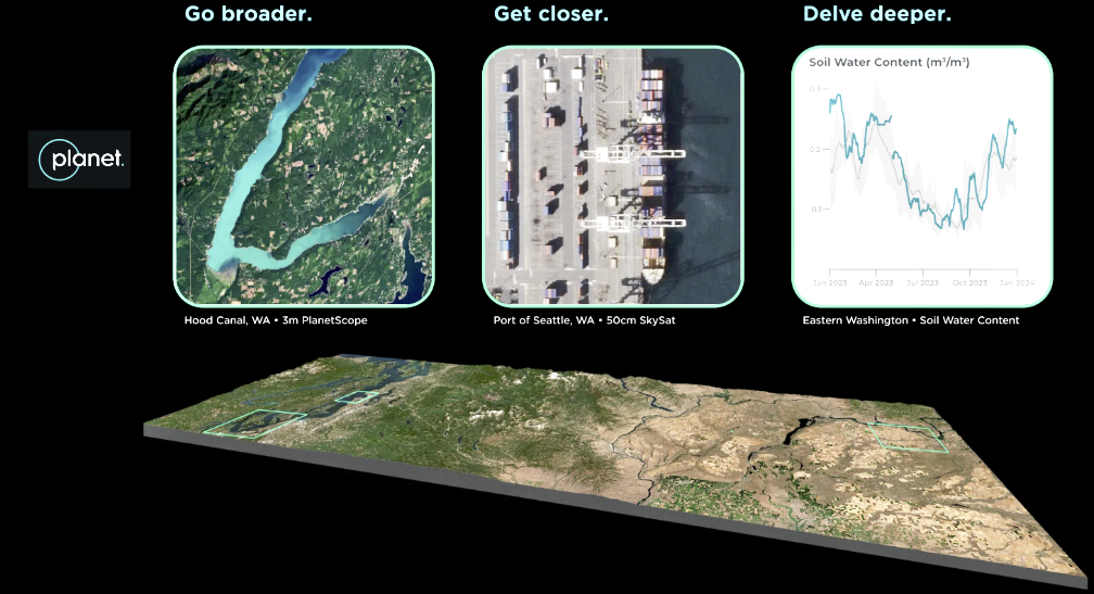
  • Enhanced Analysis-Ready PlanetScope data: Analysis-Ready PlanetScope uses proprietary AI to create harmonized, cloud-masked, and spatially consistent daily stacks of images, which enable time-series analysis and machine learning applications.
  • Updated global Road & Building Change Detection: Planet’s Road & Building Change Detection AI-based models point to where development is taking place across country-wide areas, on a weekly basis. This can help users clearly understand how and where the places they care most about are evolving.
  • New and improved Planetary Variables: Field Boundaries trace the boundaries of agricultural parcels, giving insights into different crop types and growth throughout the season. Additionally, Crop Biomass Planetary Variable now integrates Planet’s daily, global PlanetScope data, offering a ​​cloud-free, analysis-ready data product for monitoring agricultural fields.
  • Time series and statistical analysis: Within the Planet Insights Platform, users can efficiently translate imagery into formats best suited for advanced data science and AI / ML models.

With the Planet Insights Platform, users can build insights and solutions, make decisions, and act faster and aims to provide users with robust, multidimensional Earth data that are accessible and actionable at the moment of inquiry.

“Empowering our customers and partners to easily unlock the immense value within Planet data is our primary focus,” said Troy Toman, Senior Vice President of Product and Software Engineering at Planet. “Planet Insights Platform is an important milestone on that journey. We’ve unified our core offerings into a powerful set of APIs and tools that provide access to multiple data sets and powerful analytics. This breaks down the conventional barriers to leveraging the power of Earth observation data while laying the foundation for future cutting-edge capabilities that make it easier for our partners to build solutions and our customers to get the answers they need.”

“Making sense and taking action in the face of the global challenges that governments and businesses are facing today requires looking broader, closer, deeper, forward and backward in time,” said Will Marshall, co-founder and CEO of Planet. “And further, solving such challenges requires not just data, but solutions. I’m so excited for this strategic launch because it creates a central place to access the best of Planet data, analytics, and unique tools that will enable an ecosystem of customers and partners to build innovative solutions in this time of rapid global change.”

Valentin Louis, Senior Earth Observation Specialist at the Rural Payments Agency, said, “We needed fast and quick access to satellite data that helped reduce the time spent on downloading and pre-processing. That’s where Planet Insights Platform comes in. It helped us quickly distribute, assess, and process data and insights across our agency by integrating seamlessly in our current software ecosystem.”

About Planet
Planet is a leading provider of global, daily satellite imagery and geospatial solutions. Planet is driven by a mission to image the world every day, and make change visible, accessible and actionable. Founded in 2010 by three NASA scientists, Planet designs, builds, and operates the largest Earth observation fleet of imaging satellites. Planet provides mission-critical data, advanced insights, and software solutions to over 1,000 customers, comprising the world’s leading agriculture, forestry, intelligence, education and finance companies and government agencies, enabling users to simply and effectively derive unique value from satellite imagery. Planet is a public benefit corporation listed on the New York Stock Exchange as PL.

Filed Under: News

Astranis’ next generation product: Omega

April 11, 2024 by editorial

Astranis has announced Omega which, according to the company, is pound-for-pound the most powerful communications satellite for a GEO satellite to ever offer, with more than over 50 Gbps in a smallsat form factor, with expectations for launch in 2026.

Astranis made their Omega announcement at the Space Symposium, currently in session in Colorado Springs, Colorado. Omega will fly an updated version of Astranis’s proprietary software-defined radio (SDR) which, when combined with other new payload technology, means a platform with more than 50 Gbps of dedicated, uncontended capacity.

For Astranis’ commercial customers, Omega will mean advanced capabilities and lower prices for, by combining new technology and leveraging the Astranis-built hardware currently operating on orbit. For Astranis’ U.S. government customers, Omega supports the Protected Tactical Waveform and other government waveforms to operate in contested environments. The satellite platform also has a gimballed Q-/V-band antenna, greatly improving operational flexibility, and can alternatively shift gateway traffic to a Ka-band payload feed when needed.

Astranis launched its first satellite in 2023 and has announced an additional nine programs launching over the next 18 months. The first Omega flight vehicle will be complete in 2025, and the first Omega satellite will launch in 2026.

“Omega is a leap forward,” said Astranis CEO John Gedmark, “offering an industry-best throughput per kg without sacrificing the things our customers love about Astranis. With Omega, our customers simply get more throughput at lower prices, faster than ever before. How did we do it? Speed. About half of our first satellite was built in house, the most recent satellites coming off of the line are closer to 60%, and Omega will be about 70% built in house. We have hired 300+ of the most talented engineers in the country, and we all feel an immense urgency to build great things to help connect our commercial customers and support the U.S. warfighter.”

Filed Under: Featured, News

Exolaunch signs HawkEye 360 to a multi-mission launch agreement

April 10, 2024 by editorial

Exolaunch has signed a multi-mission agreement for launch and deployment services with HawkEye 360 — this marks the first collaboration between the two companies, signifying an important milestone in advancing space-based technology and geospatial intelligence capabilities.

The first launch under this occurred on Sunday, April 7th., from Kennedy Space Center’s Launch Complex 39A via SpaceX’s Falcon 9 launch vehicle. Using Exolaunch’s proprietary, flight-proven, CarboNIX separation systems, the company successfully deployed three HawkEye 360 satellites on the SpaceX Bandwagon-1 mission.

Developed by University of Toronto’s Space Flight Laboratory, these satellites intend to increase coverage over high-traffic maritime corridors at mid-latitudes, including the Indo-Pacific region.

HawkEye 360, based in Virginia, is well-known for the firm’s maritime safety technology, providing insights into global activities by delivering timely and accurate information from radio frequency (RF) data and analytics. By leveraging Exolaunch’s experience and state-of-the-art deployment solutions, HawkEye 360 aims to expand further and enhance its presence in space.

This comprehensive contract covers integration and deployment services for at least ten satellites to be delivered into orbit for HawkEye 360. Notably, all these missions will use Exolaunch’s CarboNIX separation systems and EXOpod Nova containerized deployers, showcasing the trust and confidence from HawkEye 360 in Exolaunch’s industry-leading deployment technologies.

Under the terms of the agreement, Exolaunch will support multiple missions for HawkEye 360. The payloads are expected to launch on upcoming SpaceX Rideshare missions through 2025, and they are intended to strengthen geospatial intelligence services provided by HawkEye 360.

“We are very excited to partner with Exolaunch, a global leader in launch mission integration and deployment technologies, for our cluster 9 launch and subsequent launches,” said Rob Rainhart, president of HawkEye 360. “This partnership is an important relationship for HawkEye 360. It provides a basis for affordable launch and launch integration services that allow us to focus on bringing our analytics solution to market at greater speed and efficiency. We look forward to the continued partnership and opportunities this collaboration will bring to both our companies and the industry at large.”

“We are proud to partner with HawkEye 360, a pioneering innovator in geospatial intelligence solutions, and support their long-term launch program,” said Kier Fortier, managing director of Exolaunch USA. “Our multi-mission launch and deployment agreements underscore Exolaunch’s commitment to delivering unparalleled mission management services, backed by our flight-proven deployment technologies. We are confident that our expertise and proven track record will ensure the seamless deployment and success of HawkEye 360’s missions, ultimately advancing the frontiers of space-based intelligence.”

Filed Under: News

Sierra Space launches Velocity, Horizon, and Titan satellite bus family

April 8, 2024 by editorial

Sierra Space has launched the company’s new Sierra Space Eclipse satellite bus line.

Eclipse Logo - White font black background

This cutting-edge series sets a new standard in Earth Observation (EO), servicing, mobility, logistics and communications. The Sierra Space Eclipse bus line comprises three distinct classes tailored to a wide range of missions: Eclipse Velocity, Eclipse Horizon, and Eclipse Titan, each designed to meet the rapidly evolving demands of the modern space industry.

“At Sierra Space, we are committed to innovating at speed,” said Sierra Space CEO Tom Vice. “The Sierra Space Eclipse line is a testament to our dedication to innovation, offering scalable solutions that can meet the needs of tomorrow’s space missions today. With Velocity, Horizon, and Titan, we are not just launching satellites; we are launching a new era of space commercialization.”

Eclipse Velocity
Revolutionizing the highly maneuverable small satellite sector, the Eclipse Velocity is a marvel of engineering, offering unparalleled efficiency and agility in a compact form. Designed for LEO, MEO and GEO missions, with integrated Rendezvous, Proximity Operations and Docking (RPOD) capabilities and full 6-DOF controls. Velocity is a fully refuellable system designed for dynamic space operations. Eclipse Velocity makes space more accessible than ever before.

Eclipse Horizon
The high-rate production satellite of the Eclipse line, Eclipse Horizon, is a versatile medium-class bus designed for a broad spectrum of missions, from missile warning and defense, advanced Earth observation, and communications. Eclipse Horizon stands as a beacon of reliability, affordability, and high-performance enabling horizon-to-horizon coverage for government and commercial constellation missions.

Eclipse Titan
Dominating the skies, the Eclipse Titan is the pinnacle of satellite technology. A large-class bus with unmatched capabilities, it is destined for high-demand tasks such as cislunar, GEO logistics, on-orbit re-fueling, mission support and satellite deployment.

The Sierra Space Eclipse series represents a significant leap forward in satellite technology, featuring state-of-the-art propulsion systems, integrated rendezvous, proximity operations and docking, advanced communication capabilities, and robust power management. All capabilities are housed within scalable platforms that can be customized to unique mission requirements as a tailorable bus or as a fully integrated spacecraft.

“Our Sierra Space Eclipse product line is manufactured in a high-rate production system, with the ability to be refuellable on orbit, enabling the next generation of satellites designed for dynamic space operations,” said Erik Daehler, Vice President of Sierra Space Orbital Missions and Services.

Sierra Space has a legacy of nearly 30 years of experience designing, manufacturing and successfully delivering space systems, components, and spacecraft on-orbit. The company’s Orbital Missions and Services team has designed, produced, and launched 23 space vehicles and supported more than 400 successful space and interplanetary missions with subsystems and components.

About Sierra Space
Sierra Space is a leading commercial space company at the forefront of innovation and the commercialization of space in the Orbital Age®, building an end-to-end business and technology platform in space to benefit life on Earth. With more than 30 years and 500 missions of space flight heritage, the company is reinventing both space transportation with Dream Chaser®, the world’s only commercial spaceplane, and the future of space destinations with the company’s inflatable and expandable space station technology. Using commercial business models, the company is also delivering orbital services to commercial, DoD and national security organizations, expanding production capacity to meet the needs of constellation programs. In addition, Sierra Space builds a host of systems and subsystems across solar power, mechanics and motion control, environmental control, life support, propulsion and thermal control, offering myriad space-as-a-service solutions for the new space economy.

Filed Under: News

SI Imaging Services preparing commercial SpaceEye-T EO satellite

April 8, 2024 by editorial

SI Imaging Services (SIIS) is preparing, in collaboration with its parent company, Satrec Initiative, for the launch of a 100% commercial optical satellite with ultra-high resolution.

SIIS aims to innovate the domestic and international satellite data market by venturing into ultra-high-resolution (30 cm) SpaceEye-T imagery in 2025, in addition to providing KOMPSAT imagery. SpaceEye-T is entirely funded and manufactured by its mother company Satrec Initiative (SI) and will be operated by SIIS.

SpaceEye-T is capable of distinguishing objects as small as 30 cm on the Earth’s surface from about 600 km altitude. For example, in the world of construction monitoring or industrial inspections, 30 cm data means that users can gather the same quality of data that they used to rely on drones or airplanes for. Only a few countries, such as the United States, the European Union (EU), Israel, and China, possess commercial satellites with this level of resolution in the world. The manufacturing process is progressing smoothly according to the launch schedule, and it is scheduled to be launched into space by a SpaceX rocket next year.

Engineers are assembling the ‘SpaceEye-T’ satellite.
The front is the satellite body of the satellite, and the black pillar at the back is a large lens to be mounted to the satellite. Photo is courtesy of the company.

SpaceEye-T represents SIIS’s next-generation satellite. It has significantly improved in performance compared to previously produced satellites. With a resolution of 30 cm, SpaceEye-T can observe the Earth’s surface in great detail. This capability can be beneficial in various fields such as urban planning, natural resource management, disaster management, and military applications. The deployment of such ultra-high-resolution satellites is expected to offer innovative applications across various sectors due to these advantages. SIIS plans to launch three additional SpaceEye-T smallsats by 2027.

“Our growing constellation provides a reliable intelligence source, enabling a faster, more accurate response to changes occurring anywhere on the planet. Our vision takes the Earth-Observation industry one step further, helping commercial sector customers easily access the clearer and faster satellite data that can taking their decision-making during critical situations in various industries,” said Moongyu Kim, CEO of SIIS.

SI Imaging Services provides satellite imagery of Korean Multi-Purpose Satellite (KOMPSAT) 3, 3A, and 5. SIIS contributes to the remote sensing and earth observation industries with very-high-resolution optical and SAR images together with over 160 partners worldwide. Satellite imagery is used in remote sensing fields such as mapping, agriculture, and disaster observation. 

SIIS’s next venture, the launch of the ultra-high resolution (30 cm) SpaceEye-T in 2025, aims to revolutionize the satellite market. Satrec Initiative is a world-leading Earth Observation solutions provider. SI was founded in 1999 by the engineers who developed the first Korean satellite and a series of advanced smallsats The company has been focusing on developing high-performance small/medium satellite systems for Earth observation missions. The company has contributed to the success of more than 28 international and domestic space programs over the past 30 years.

Filed Under: News

Space Flight Laboratory (SFL) confirms successful deployment of HawkEye 360 smallsat clusters

April 8, 2024 by editorial

HawkEye 360 Cluster 9 in the Space Flight Laboratory (SFL) cleanroom being readied for launch, March 2024. (Photo: Business Wire)

Space Flight Laboratory (SFL) has confirmed that six radio frequency geolocation smallsats developed for HawkEye 360 have successfully communicated with ground control — the HawkEye 360 Cluster 8 and 9 satellites were launched from Florida aboard the SpaceX Bandwagon-1 Rideshare mission.

The two new three-satellite clusters bring to 27 the total number of geolocation microsatellites developed by SFL for HawkEye 360, which integrated Cluster 8 at its own plant in Virginia under SFL’s Flex Production Program. For Cluster 9, which represents the next evolution and includes updated payload and platform features, SFL handled the entire process, including development, integration, and testing, at its Toronto facility.

HawkEye 360 selected SFL to develop its satellites due to the importance of attitude control and formation flying by multiple spacecraft for accurate RF signal geolocation. SFL has innovated compact, low-cost formation-flying technology at a maturity and price point that, according to the company, no other smallsat developer can credibly offer.

SFL built the HawkEye 360 Pathfinder satellites on its 15 kg NEMO platform. All subsequent clusters have been developed on the larger 30 kg SFL DEFIANT bus.

The HawkEye 360 constellation detects, characterizes and geolocates RF signals for a variety of communications, navigation, and security applications. Clusters 8 and 9 were launched in mid-inclination orbits to increase coverage over the busiest maritime traffic corridors at mid-latitudes, including the Indo-Pacific region, according to HawkEye 360.

Established in 1998, SFL has developed 76 operationally successful smaller satellite missions totaling more than 300 cumulative years in orbit. Another 20 missions are now under development by SFL, which offers a complete suite of nano-, micro- and small satellites – including high-performance, low-cost CubeSats – that satisfy the needs of a broad range of mission types from 3 to 500 kilograms. For a comprehensive list of SFL high-performance satellite platforms, please access this direct infolink…

“SFL is proud to play a key role in the development of HawkEye 360’s space assets as it continues to expand and enhance its unparalleled space-based RF data detection and analytics capabilities,” said SFL Director Dr. Robert E. Zee.

About Space Flight Laboratory (SFL)
SFL generates bigger returns from smaller, lower cost satellites. Small satellites built by SFL consistently push the performance envelope and disrupt the traditional cost paradigm. Satellites are built with advanced power systems, stringent attitude control and high-volume data capacity that are striking relative to the budget. SFL arranges launches globally and maintains a mission control center accessing ground stations worldwide. The pioneering and barrier-breaking work of SFL is a key enabler to tomorrow’s cost-aggressive satellites and constellations.

Filed Under: Featured, News

Control moment gyroscopes deliver a quantum leap in smallsat capabilities

April 6, 2024 by editorial

For more than a decade, RTX’s small satellite manufacturer and mission services provider, Blue Canyon Technologies’, high-precision, advanced solutions have disrupted the space industry by demonstrating how lower-cost smallsats serve as a complement to larger satellites in the commercial, science and defense sectors.

Now, the same can be said for the company’s components. By leveraging existing technology, Blue Canyon is bringing the final frontier a little closer to home.

Just 10 years ago, the capabilities of inexpensive smallsats were limited and tech demos were the typical posture. Today, we’re at an inflection point where significant investment and expectation is being put into constellations of high-performance operational smallsats. The capability and mission value multipliers offered by Control Moment Gyroscopes (CMG) are already becoming market differentiators and is expected to accelerate.

Previously reserved for larger, more traditional satellites, CMGs offer at least 10 times the torque of reaction wheels with up to five times less power. They provide a quantum leap in the speed with which a spacecraft can reorient and point in another direction, multiplying the return on investment for any mission limited by the responsiveness of its bus platform, especially Earth Observation (EO).

This advanced spacecraft agility, coupled with low jitter that maximizes the quality of mission data, allows CMGs to offer the performance needed to maximize payload-pointing operations while on-orbit.

Blue Canyon Technologie has delivered multiple sets of flight CMGs designed at a SWaP-C appropriate level for the smallsat market while maintaining the increased performance for which CMGs are known. Additionally, Blue Canyon stands ready to integrate CMGs into the firm’s standard product offerings to help customers achieve extreme agility and precision pointing.

Blue Canyon offers the CMG-12, which has 12-Newton-meter-second rotor momentum and 12Nm of output torque, and the CMG-8, featuring 8Nms of momentum and 8Nm of output torque. The CMG-12 is designed using a radiation-hardened parts paradigm with redundancy options to meet the risk tolerance and mission length needs of various markets.

The vibration and jitter isolation are integrated into each CMG, with the control electronics as a separate unit. CMGs provide long life, high-control accuracy, and low-induced vibration performance required for demanding precision-pointing missions.

To aid customers in harnessing this opportunity, Blue Canyon is integrating CMGs into its standard spacecraft platforms and turnkey guidance, navigation and control systems. These platforms provide increased performance, low-cost, high-reliability CMG-based solutions designed for high-volume production in response to space mission needs.

Founded in 2008, Blue Canyon built its reputation on flight-proven, reliable components, with nearly 300 sun sensors, 200 star trackers and 800-plus reaction wheels launched to date. With 70 spacecraft launched since its inception, Blue Canyon has an impressive flight heritage of 100 years on-orbit for spacecraft, 151 years for turnkey guidance and navigation systems and 3,100 years for components.

The company’s components and bus platforms have completed missions ranging from Very-Low Earth Orbit (VLEO), LEO, GEO, Cislunar and an interplanetary journey. Equipped with dedicated facilities and staff for each business unit and in-house production resources, Blue Canyon continues to solve the toughest challenges in space with its high-performance solutions to support all types of missions regardless of size or scope.

Further information is available via an email to info@bluecanyontech.com

Filed Under: News

HawkEye 360s Clusters 8 + 9 to launch aboard Bandwagon

April 6, 2024 by editorial

HawkEye 360 is preparing to launch six satellites aboard SpaceX’s Bandwagon-1 Rideshare mission from Florida on Sunday, April 7, 2024, with the launch window opening at 7:12 PM.

This is the first time HawkEye 360 is placing two clusters simultaneously into orbit, positioned at mid-inclination for increased coverage over the busiest maritime traffic corridors of the world.

Clusters 8 and 9 are equipped with upgraded payloads that enable up to a 5x increase in data collection, significantly larger collection bandwidths, and multi-band signal collection. High-speed downlink transmitters quadruple the speed at which data is delivered back to the Earth, bringing actionable, multi-dimensional, geospatial information for swift and informed decision-making. The mid-inclination orbit of Clusters 8 and 9 will further support HawkEye 360’s work to help monitor and prevent Illegal, Unreported, and Unregulated (IUU) fishing across the Indo-Pacific region.

HawkEye 360 currently operates a constellation of 23 satellites. Once Clusters 8 and 9 are in orbit, the constellation of 29 satellites will detect, characterize, and geolocate RF signals from a broad range of emitters used for communication, navigation, and security.

“The launch of Clusters 8 and 9 underscores HawkEye 360’s commitment to consistently enhance our constellation to address the mission needs of our customers across the globe,” said Rob Rainhart, HawkEye 360 President. “Through the dedication and ingenuity of our space team and partner Space Flight Laboratory (SFL), we are pleased to introduce significant upgrades to our satellite payloads that will further significantly expand our RF data collection and processing capabilities.”

Filed Under: News

All eyes on the ESA Arctic Weather Satellite

April 5, 2024 by editorial

$video.data_map.short_description.content

ESA’s new Arctic Weather Satellite has taken center stage at OHB’s facilities in Stockholm, Sweden, before the spacecraft is packed up and shipped to California for a launch currently scheduled for June.

Embracing the New Space approach to demonstrate new concepts in a cost-effective and timely manner, the Arctic Weather Satellite has been designed to show how it can improve weather forecasts in the Arctic.

Today, satellites provide a wealth of information that meteorologists use routinely to forecast the weather. Geostationary satellites, which are positioned 36,000 km above the equator, do not have visibility over higher latitudes, so cannot be used for Arctic weather forecasting.

While the MetOp satellites return data over the poles, they can take up to 24 hours to achieve global coverage – which limits data for short-term weather forecasts worldwide.

Enter the Arctic Weather Satellite: a new prototype mission that will demonstrate that it can fill this gap – providing data for very short-term weather forecasts and nowcasts in the Arctic.

The satellite is currently in its last stages of being checked and readied for shipment by air to California ahead of its launch. Before it embarks on its journey, the satellite has been on display in the cleanroom at OHB Sweden – the prime contractor for the mission.

The Arctic Weather Satellite weighs just 120 kg and carries a 19-channel cross-track scanning microwave radiometer which will provide high-resolution humidity and temperature soundings of the atmosphere in all weather conditions. Its enhanced sounding will capture short fluctuations in humidity that can be used to better infer wind information for tracking storms and extreme weather.

The Arctic Weather Satellite is the forerunner of a potential constellation of satellites, called EPS-Sterna, that ESA will build for Eumetsat if the prototype works as expected.

Final tests for Arctic Weather Satellite

EPS-Sterna is envisaged as a constellation of six smallsats in three orbital planes to supply an almost constant stream of temperature and humidity data from every location on Earth.

While weather forecasting for the Arctic region is the focus, data from the Arctic Weather Satellite and the potential constellation will also be used to improve weather forecasts around the world and contribute to climate change research.

The Arctic Weather Satellite has been developed and built on a tight schedule: it has taken just 36 months from ESA awarding the industrial prime contract to OHB in Sweden and the satellite being completed.

ESA’s Director of Earth Observation Programs, Simonetta Cheli, said, “The effects of the climate crisis are being felt more in the Arctic than in other parts of the world. We know that what happens in the Arctic doesn’t stay in the Arctic: changes in this delicate icy ecosystem affect the Earth system as a whole. We are extremely excited to see the Arctic Weather Satellite ready to demonstrate its capabilities and allow, for the first time, nowcasting in the Arctic, for the benefit of weather prediction and climate change worldwide.”

Benoit Mathieu, Managing Director at OHB Sweden, said, “We are proud that ESA entrusted us this mission. After 36 months of contract, the satellite is at the stage as planned at contract signature. This is a tremendous success and underlines our reliability as a small satellite manufacturer. This was made possible by the flight proven heritage of our InnoSat platform, the engagement of our teams and of the entire supply chain, and the very good collaboration with the ESA team which fully embraced the New Space approach.”

Filed Under: News

SwRI to build spacecraft bus for in-space refueler servicer program

April 5, 2024 by editorial

Southwest Research Institute (SwRI) will build, integrate and test a small demonstration spacecraft as part of a $25.5 million Space Mobility and Logistics (SML) prototyping project funded by the U.S. Space Force and led by prime contractor Astroscale U.S.

The spacecraft, called the Astroscale Prototype Servicer for Refueling (APS-R), will refuel other compatible vehicles while in geostationary orbit.

“Running low on fuel is a common issue for spacecraft in Earth orbit,” said SwRI Staff Engineer Steve Thompson, the SwRI project systems engineer. “When they have expended all of their fuel, their mission ends — even though the vehicle may be in otherwise excellent health. A refueling vehicle can extend those missions, and we can get additional lifetime out of spacecraft that are already in orbit.”

The APS-R will operate in GEO around the Earth, meaning it will follow a circular orbit in sync with the Earth’s rotational period of 24 hours. The spacecraft will carry hydrazine propellant from a depot, also in geostationary orbit, to the spacecraft in need of fuel. The APS-R can service any spacecraft fitted with a compatible refueling port.

“Recently, other approaches to life extension have emerged, such as a vehicle that can use its thrusters to push another spacecraft where it needs to go after it runs out of fuel,” Thompson said. “A refueling vehicle broadens life extension options with a flexible alternative.”

Over the next 16 months, SwRI will construct the host vehicle for the APS-R in the Institute’s new, 74,000-square-foot Space System Spacecraft and Payload Processing Facility, which was created to rapidly respond to customers needing to design, assemble and test spacecraft, particularly small satellites.

“The maximum dimensions are 24-by-28-by-45 inches when stowed for launch, and the total vehicle launch mass is 437 pounds, including propellant,” Thompson said.

When the host spacecraft bus is complete, SwRI will integrate the Astroscale-supplied payload and perform system-level environmental testing to prepare the vehicle for launch. SwRI will deliver the launch-ready APS-R by 2026.

Filed Under: News

  • « Go to Previous Page
  • Go to page 1
  • Go to page 2
  • Go to page 3
  • Go to page 4
  • Go to page 5
  • Go to Next Page »

Primary Sidebar

WEEKLY NEWSLETTER

Archives

  • February 2026
  • January 2026
  • December 2025
  • November 2025
  • October 2025
  • September 2025
  • August 2025
  • July 2025
  • June 2025
  • May 2025
  • April 2025
  • March 2025
  • February 2025
  • January 2025
  • December 2024
  • November 2024
  • October 2024
  • September 2024
  • August 2024
  • July 2024
  • June 2024
  • May 2024
  • April 2024
  • March 2024
  • February 2024
  • January 2024
  • December 2023
  • November 2023
  • October 2023
  • September 2023
  • August 2023
  • July 2023
  • June 2023
  • May 2023
  • April 2023
  • March 2023
  • February 2023
  • January 2023
  • December 2022
  • November 2022
  • October 2022
  • September 2022
  • August 2022
  • July 2022
  • June 2022
  • May 2022
  • April 2022
  • March 2022
  • February 2022
  • January 2022
  • December 2021
  • November 2021
  • October 2021
  • September 2021
  • August 2021
  • July 2021
  • June 2021
  • May 2021
  • April 2021
  • March 2021
  • February 2021
  • January 2021
  • December 2020
  • November 2020
  • October 2020
  • September 2020
  • August 2020
  • July 2020
  • June 2020
  • May 2020
  • April 2020
  • March 2020
  • February 2020
  • January 2020
  • December 2019
  • November 2019
  • October 2019

© 2019–2026 SatNews

Insert/edit link

Enter the destination URL

Or link to existing content

    No search term specified. Showing recent items. Search or use up and down arrow keys to select an item.
      x
      Sign Up Now!

      Enjoy a free weekly newsletter with recent headlines from the global SmallSat industry.

      Invalid email address
      We promise not to spam you. You can unsubscribe at any time.
      Thanks for subscribing! You will now receive weekly SmallSat News updates.
      We love our advertisers.
      And you will too!

      Please disable Ad Blocker to continue... We promise to keep it unobtrusive.
      We promise not to spam you. You can unsubscribe at any time.
      Invalid email address
      Thanks for subscribing! Please check your email for further instructions.