• Skip to main content
  • Skip to primary sidebar
  • Home
  • News
  • Featured
  • More News ⌄
    • SatNews
    • SatMagazine
    • MilSatMagazine
  • Events ⌄
    • MilSat Symposium
    • SmallSat Symposium
    • Satellite Innovation
  • Contacts
  • SUBSCRIPTION

SmallSat News

You are here: Home / Archives for editorial

editorial

Direct 2-Way, Sat-To-Mobile-Phone Comms Via Cell Towers In Space Are Proven Viable By Lynk Global

September 29, 2021 by editorial

Lynk Global, Inc. (Lynk) has registered hundreds of unmodified mobile phones to their 5th cell-tower-in-space in three different countries (UK, US and Bahamas). This critical milestone conclusively proves Lynk’s proprietary core satellite technology works with ordinary mobile phones on Earth, enabling broadband, voice and text messaging — from everywhere — with the phone in a user’s pocket.

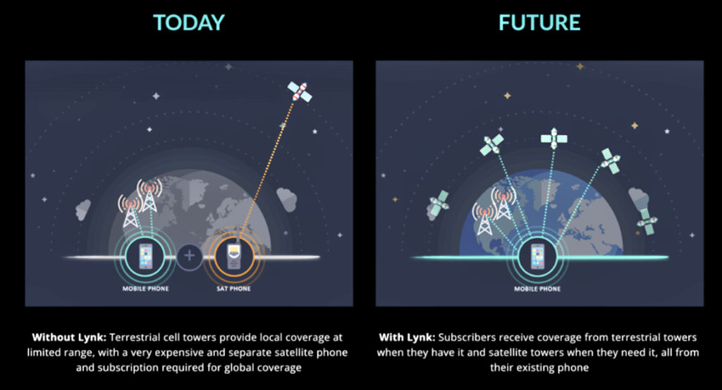
Lynk’s 5th satellite (named “Shannon”), launched on June 30, 2021, has connected with, and registered, hundreds of mobile phones in initial tests, even in Virginia where Lynk connected in spite of the “noise” created by millions of mobile phones. Lynk has successfully repeated the tests in the United Kingdom, with testing permission from Ofcom, and in the Bahamas with the support of mobile network operator (MNO) partner Aliv. Lynk is the world’s only independently certified provider of cell-tower-in-space connectivity.

“Lynk has provided independent testing data that proves they are connecting existing Aliv devices that roam onto the Lynk system on areas outside the Aliv coverage footprint in the Bahamas,” said Dr. Stephen Curran, Aliv’s CTO. “The testing has proven the technology’s ability to simultaneously register and authenticate mobile devices. Lynk will provide a critical maritime communication service for our users. The Caribbean is also known for extreme weather events, and for earthquakes. Lynk will assist Aliv in providing emergency communications back-up when the network experiences major issues, and our sites are down.”

“Six years ago, the entire world thought it was impossible for a satellite to connect two-ways to existing mobile phones in use today,” says Charles Miller, Lynk’s CEO and co-founder. “Lynk has now done the impossible. We recently announced the first operators to sign up for our Flagship Carrier Program, Aliv in the Bahamas and Telecel Centrafique in the Central African Republic. These and others will launch commercial services in their countries in July 2022, beginning our journey to serve the unconnected around the world. Lynk is solving a problem that nobody else in the world is solving. We call it “The 0G Problem”. Next time you hear somebody use the phrase “5G”, ask yourself “How does 5G solve the World’s 0G problem? The answer … it doesn’t.”

“Lynk has solved the ‘Uplink Challenge’,” said Lynk CTO and co-founder, Tyghe Speidel. “Our 5th satellite has successfully completed it’s commissioning tests which includes our antenna and core mobile processing tests demonstrating the ability to receive and process signals from terrestrial subscriber phones on Earth that are out of terrestrial coverage. This is especially tough because of the noise from millions of other phones communicating terrestrially in the same mobile operator spectrum at the same time in our spot beam. We have repeatedly demonstrated the intricate two-way signaling required for a phone to connect to our cell tower in space, involving multiple instances of uplink and downlink messages, including a device request for channel access, and then the corresponding authentication and location update procedures. To date, we’ve done this with hundreds of phones in the UK, the Bahamas, and the US. This has never been proven before with a satellite cell tower and Lynk has done it. As part of the testing, we have also proven our signaling link budget (the signal power analysis) to close the link with existing mobile phones, as well as proven our ability to not interfere with existing terrestrial mobile operations while operating in the same bands.”

For more technical information, read How Lynk Proved Direct Two-way Satellite-to- Mobile-Phone Connectivity that explains what Lynk has accomplished with the hundreds of phone registration tests.

Lynk Global Inc. is a mobile technology company focused on providing universal connectivity for mobile phones and the world’s only independently verified space-based mobile network provider. The company’s patented technology allows standard mobile phones to be connected virtually anywhere via low-Earth-orbit satellites without any change to hardware or software. Headquartered in Falls Church, VA, Lynk’s leadership and engineering teams are experts in satellite engineering, space flight and policy, and wireless technologies.

Filed Under: News

AAC Clyde Space Strengthens Their Executive Team

September 29, 2021 by editorial

AAC Clyde Space has recruited Stefania Mandirola as Chief Operating Officer as part of a strengthening of the firm’s management team to meet the broader needs of the group that now spans six companies on three continents.

Stefania will take on the COO starting on October 6 to ensure operational efficiency as the Group continues to expand. In the last 12 months, AAC Clyde Space has acquired three companies in the United States, Netherlands and Sweden; set up a new space company in South Africa; and has experienced rapid, organic growth. To further support this development, Kulwinder Bhumbra will join the Group as HR Director in November.

Following these key additions, the executive management team has been reshaped, with Peter Anderson appointed the Chief Commercial Officer of the group and Dino Lorenzini becoming the Chief Scientific Officer of AAC Clyde Space.

Stefania joins AAC Clyde Space from Rolls-Royce Aerospace where she has held various leadership positions, most recently as Head of Supplier Management. She holds a Master of Science from Politecnico di Milano.

“I am thrilled to have joined AAC Clyde Space at a such pivotal time of growth and I am looking forward to leading their group operations globally. Space is an extremely exciting sector right now: satellites data and services have the potential to address some of the critical sustainability challenges of our times. Space is awesome,” saidStefania Mandirola.

Kulwinder joins from Volvo and brings more than 10 years’ experience in HR roles and has worked through a variety of change initiatives.

These latest appointments follow Dr. Andrew Carrel joining the Group in May 2021 from a position as CTO of Rezatec, a specialist company in geospatial analytics. He has worked in the space industry for over 20 years.

The executive management team will now consist of CEO Luis Gomes, CFO Mats Thideman, COO Stefania Mandirola, CTO Andrew Strain, CCO Peter Andersson, Vice President of Future Programs Andrew Carrel, HR Director Kulwinder Bhumbra as well as the Chief Scientific Officer, Dino Lorenzini.

“AAC Clyde Space has grown aggressively during the past year and aims to continue to do so. By adding further expertise from successful high-tech companies, we strengthen our prospects for success and can aim even higher. I look forward to working together with the new executive management team to reach ambitious goals,” said AAC Clyde Space CEO, Luis Gomes.

AAC Clyde Space is targeting a turnover of 500 MSEK (Million Swedish Kroner) in 2024. In its report for the first half of 2021, the Group reported sales of 84.2 MSEK and an orderbook of 413 MSEK.

Filed Under: News

Blending Competencies Are TXMission + Arralis Technologies For Comm Products

September 29, 2021 by editorial

TXMission has signed a technology, sales and distribution agreement with Arralis Technologies Ltd., a leading, advanced millimeter-wave communications solution provider.

The companies will jointly develop a suite of communication products for smallsat, HAPS, UAV and airborne applications that require high-performance and extremely low size, weight and power. Development will initially focus on a range of advanced Ka-band transceivers with integrated gigabit Software Defined Radios (SDRs), satellite terminals, phased array antennas and network management systems.

Steve McHugh, Chairman of TXMission, said, “This is another exciting collaboration that combines our unique SDR technology with Arralis’ outstanding RF capabilities, allowing us to provide a range of complete advanced satellite and airborne communications systems.”

Mike Gleaves, CEO of Arralis, said, “This is excellent news for satellite integrators seeking a high data rate communications platform. This strategic partnership enables a one-stop risk-free route to implementation, with minimum required expertise and maximum benefits.”

TXMission is a New Space company that provides advanced Software Defined Radios (SDRs), compatible ground equipment and network management systems for the smallsat, HAPS, UAV and airborne communications markets.

Arralis provides world leading expertise in RF, micro and millimeter-wave technology. Arralis excels in Monolithic Microwave Integrated Circuits (MMICs), packaged component modules, proprietary antenna technology and integrated radar and communications front-end platforms that provide high data rate wireless communications. Arralis products are used in both global and space environments where accuracy and reliability are critical. Arralis works with some of the world’s largest aerospace, automotive, defence and communications companies.

Filed Under: News

UPDATE: NASA’s Landsat 9 Mission Successfully Launched By ULA From Vandenberg Space Force Base

September 27, 2021 by editorial

A United Launch Alliance (ULA) Atlas V rocket lifts off at 11:12 a.m. from Vandenberg Space Force Base on September 27, 2021, carrying NASA’s Landsat 9 and multiple smallsat payloads to orbit.

ULA’s Atlas V rocket on the launch pad awaiting the countdown.

Atlas V accelerated using 860,000 pounds of thrust while performing the pitch and yaw maneuvers off the launch pad to obtain the proper heading, en route to a near-polar, sun-synchronous orbit to deploy Landsat 9.

Original information…

The launch is on track for September 27 from Space Launch Complex-3 at Vandenberg Space Force Base. Launch is planned for 11:11 a.m. PDT. The live launch broadcast starts at 10:30 a.m. PDT on September 27 at www.ulalaunch.com.

Landsat 9 is a joint mission of NASA and the U.S. Geological Survey (USGS). In addition to Landsat 9, this mission includes the ESPA Flight System (EFS) that will deploy multiple cubesats after Landsat 9 separation. The Atlas V will deploy the Landsat 9 and the smallsats into two different orbits, enabling the first, four-burn, Centaur mission for ULA on an Atlas V rocket. The Centaur upper stage has the capacity for increased performance, and the flight design of the Landsat 9 mission takes advantage of that capability.

The mission will launch on an Atlas V 401 configuration rocket that includes a 13.7 ft. (4 meters) Extra Extended Payload Fairing (XEPF) and stands 194 ft. (59 meters) tall. The Atlas booster for this mission is powered by the RD AMROSS RD-180 engine. Aerojet Rocketdyne provided the RL10C-1 engine for the Centaur upper stage.

The Russian-built RD AMROSS RD-180 engine for Atlas V.

This will be the 88th launch of the Atlas V rocket and 20th mission launched on an Atlas V in partnership with NASA’s Launch Services Program (LSP). This launch is the 300th Atlas launch from Vandenberg Space Force Base. To date, ULA has launched 144 times with 100 percent mission success.

“We are proud to continue to serve as the primary launch provider for Landsat missions. ULA and our heritage launch vehicles have launched every Landsat mission since 1972,” said Gary Wentz, ULA vice president of Government and Commercial Programs. “The Landsat series provides outstanding data for Earth environment and science-based research and Landsat 9 will add to these capabilities. We have worked alongside our partners, in a challenging health environment, to prepare to launch this important mission that will empower Earth research from space for decades to come.”

Filed Under: News

Terran Orbital Partners With Space Florida To Build 660,000 Sq. Ft. Facility To Manufacture Space Vehicles

September 27, 2021 by editorial

Terran Orbital, in partnership with Space Florida, joined with Florida Governor Ron DeSantis as he announced the company’s planned development of the world’s largest and most advanced “Industry 4.0” space vehicle manufacturing facility.

The facility will be constructed at the Launch and Landing Facility (LLF) on Merritt Island, Florida, and will consist of ten automated and augmented hangers capable of producing thousands of different types of space vehicles per year.

The 660,000 square foot facility will feature a campus-based, AI controlled supply chain and will feature 3D printing and additive manufacturing technologies to permit rapid space vehicle delivery to market, as well as capabilities to produce and fabricate the highest quality, technologically advanced, printed circuit board assembly with extensive electronic storage vaults. In addition, the facility will use augmented and assisted workforce product lines to produce a vast array of complex electronic and mechanical devices.

“I am excited to announce that Terran Orbital will be investing $300 million in the Space Coast to build the largest satellite manufacturing facility in the world,” said Governor DeSantis. “Satellite manufacturing is and will continue to be an important part of the economy in the Space Coast, and with this announcement we are upping the ante. In Florida we are going to continue to take the lead on space by investing in infrastructure, training highly skilled workers and maintaining an economic climate that allows companies like Terran Orbital to thrive. I congratulate them on a great decision to come to Florida.”

“We are pleased to partner with Space Florida to build a facility that we view as a national asset: a commercially funded contribution to our nation’s space industrial base,” said Marc Bell, co-founder and chief executive officer of Terran Orbital. “Not only will we be able to expand our production capabilities to meet the growing demand for our products, but we will also bring valuable space vehicle manufacturing opportunities and capabilities to the State of Florida, investing over $300 million in new construction and equipment. By the end of 2025, we’re going to create approximately 2,100 new jobs with an average wage of $84,000.”

“Space Florida congratulates Terran Orbital on its selection of Florida and our Launch and Landing Facility at the Kennedy Space Center (KSC) for a new satellite manufacturing complex,” said Space Florida President and CEO Frank DiBello. “This announcement is yet another milestone in Florida’s leadership in space commerce, offering state-of-the-art development, including launch-on-demand and satellite-on-demand capability at the spaceport. We look forward to Terran’s Orbital’s success in the years to come and the continued activity and growth in Florida.”

Filed Under: News

HawkEye 360 Awarded Million$$ Contract From National Geospatial-Intelligence Agency

September 27, 2021 by editorial

HawkEye 360 Inc. has been awarded a contract by the National Geospatial-Intelligence Agency (NGA) to help the agency discover, characterize and map activities which emit energy in the RF bands of the electromagnetic spectrum.

The $10 million, base year plus four option years contract, will support users throughout the NGA enterprise, including the Combatant Commands and other designated mission partners. HawkEye 360 will provide NGA the means to develop global datasets, enabling users to discover and monitor a broad range of RF activity across large geographic areas.

HawkEye 360’s data will support a variety of analytics missions for NGA, including military activity and the trafficking of military, nefarious, non-state and transnational criminal (or illicit) activity. The company’s growing constellation of satellites will provide insight into developing events in a timely manner, and the company will work collaboratively with NGA on an ongoing basis to effectively meet the agency’s mission needs.

HawkEye 360 operates a constellation of nine, RF-monitoring satellites. Twenty-one additional satellites are fully funded and scheduled for launch in 2021 and 2022. Once complete, this baseline constellation of 30 satellites will provide collection revisits as frequent as every 20 minutes. Following the establishment of the baseline constellation, HawkEye 360 plans to launch a second-generation constellation of 30 additional satellites by 2025 to satisfy projected capacity and operational requirements. The company’s RF data and analytics produce actionable insights for national, tactical and homeland security operations, maritime domain awareness, environmental protection and a growing number of new defense and commercial applications.

“We’re pleased to be moving from the pilot into an NGA long-term operational contract, which showcases the value of unclassified, shareable commercial RF insights,” said HawkEye 360 CEO, John Serafini. “NGA is a leader within the United States government in leveraging the growing strengths of the commercial GEOINT sector to fulfill their mission to support policymakers and war fighters. HawkEye 360 is grateful for the opportunity to come alongside NGA and deliver results to customers with some of the most pressing demands.”

“This program is an excellent example of agile acquisition rapidly delivering high-impact GEOINT to the warfighter,” said Alex Fox, EVP for Business Development, Sales, and Marketing. “NGA leveraged a National Reconnaissance Office commercial integration study contract with HawkEye 360 in September 2020 to execute a test and evaluation contract with the only RF provider capable of meeting the requirements. NGA issued a competitive RFP in March 2021 and awarded the contract in July 2021 — a fantastic example of quickly bringing a new capability to the GEOINT community. We are excited to continue working with NGA to address current mission requirements and expand the RF GEOINT tradecraft to address an even larger set of mission requirements, much like NGA has done with their pioneering use of commercial imagery.”

Filed Under: News

Horizon Technologies Closes Million$ Sale — Plus, Amber™ Smallsat Info

September 27, 2021 by editorial

Horizon Aerospace Technologies, a subsidiary of Horizon Technologies, has announced an approximately $1 million sale of FlyingFish™ 
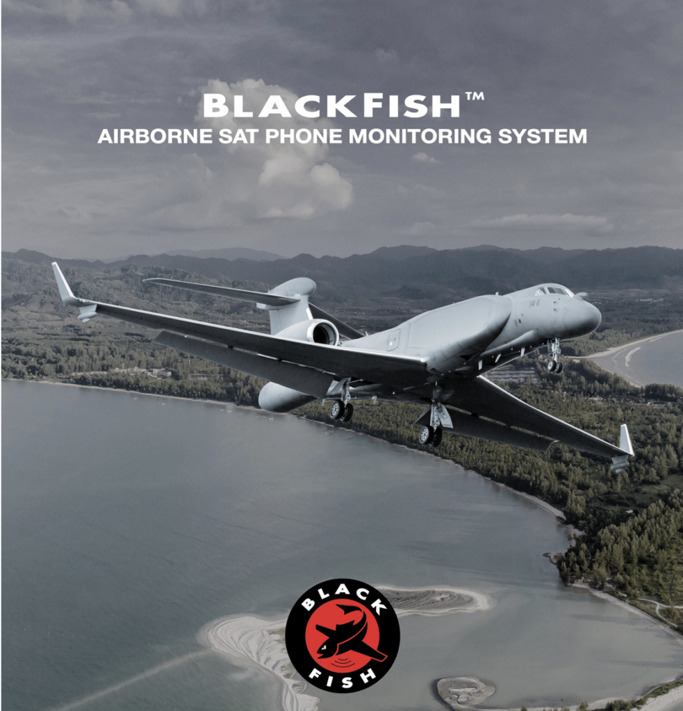
airborne SIGINT systems to a European prime contractor for a Southern European government end-user. The systems will be operated on manned ISR fixed-wing aircraft to support NATO and EU missions in the Mediterranean Sea and Northern Africa.

John Beckner, CEO, Horizon Technologies said, “We are happy to add another end-user to the list of countries who operate our FlyingFish™ and new BlackFish™ SIGINT systems. FlyingFish™ is in operation 24/7 around the globe saving refugees, combating illegal fishing, piracy, terrorism, and transshipments. There is also a great deal of interest in our upcoming Amber™ smallsat launch.”

Recently, Horizon Technologies completed its Series A funding round with Maven Capital Partners and Virgin Money.

Horizon Aerospace Technologies is a leader in airborne Sat Phone monitoring systems for Intelligence, Surveillance, and Reconnaissance (ISR) applications, equipping governments worldwide by enhancing their SIGINT capabilities. The firm is the Original Equipment Manufacturer (OEM) for the FlyingFish™ BlackFish™ SIGINT systems that are in operation on numerous platforms across the glove. The company participates daily in SAR missions via NATO and FRONTEX in the Mediterranean Sea and are heavily involved in international operations around the globe. Horizon Space Technologies is the prime contractor for the UK Government’s Amber™ program that will consist of Amber™ cubesats in multiple orbital planes, providing global Maritime Domain Awareness (MDA) data to NMIC (led by the Royal Navy).

John Beckner, CEO, Horizon Technologies, and Bash Ahmed, COO, Horizon Aerospace Technologies.

Regarding the Amber™ satellite from Horizon Space Technologies, earlier this past summer, AAC Clyde Space (AAC) won a £4.6 million order for a full turnkey solution from Horizon Space Technologies, including two new satellite launches, operations and data delivery.

The satellites will become part of the Horizon Space Technologies’ Amber™ constellation dedicated to delivering MDA intelligence data.

The EPIC-6U smallsats will be able to locate and track vessels worldwide by geolocating and demodulating RF signals in a system that can be used to fight piracy, illegal trans-shipments, illegal fishing, and refugee smuggling, but can also be used for other purposes such as detecting and tracking a variety of RF emitters.

The mission delivers a commercial service and may be extended to include more than ten (10) additional Amber™ smallsats. Horizon Space Technologies’ first customer is the UK National Maritime Information Centre (NMIC) in Portsmouth.

The two satellites in this order are scheduled for launch in the second half of 2022. This order is a follow-on order from the Satellite Applications Catapult IOD program (IOD-3 AMBER), for which AAC will also deliver a 6U cubesat to the International Space Station (ISS) in 2021 for deployment.

“We are looking forward to expanding our current partnership with AAC Clyde Space as we move forward with more launches and advanced versions of our mission payload. They are a key part of the Amber™ team,” said Horizon Technologies CEO, John Beckner.

Filed Under: News

Integrasys Updates Their Beam Budget Tool

September 27, 2021 by editorial

Beam Budget has been updated and, according to developer Integrasys, is an essential tool for New Space LEO and MEO constellations.

The company has completed the updating of the LEO option, in order to offer a flexible solution for these new constellations. Beam Budget enables the user to seamlessly manage a LEO network by simultaneously calculating several dynamic links in real-time, as well as selecting a period of time within which to obtain the necessary metrics, tall o ensure a reliable infrastructure.

The latest development brings an update on the constellations database. This update includes up-to-date constellations as well as the new feature of the laser inter-satellite link, creating a robust network design and taking advantage of assets and latest constellations in any orbit.

For example, a GEO satellite constellation can transmit to a smallsat constellation to optimize latency for a particular application. LEO and MEO assets can connect via Laser with GEOs to ensure resiliency and availability. The tool allows comparisons in a matter of clicks for varying constellation throughput and service for parabolic and flat antennas. Integrasys has also improved the LEO and MEO reporting capabilities, with a Dual analysis of the forward and return link, as well as detailed information about the beams and coverage. The metrics are represented graphically in order for sales teams to more easily understand the results and then export this data and reportto Excel or to a PDF.

The company has also developed a complete footprint that includes the satellite footprints and their frequency range, with the specific frequency ranges defined by the operator. High precision in the gain of each beam is also produced, not only in working with discrete 2dB contours between each band, but also interpolating the gain to the exact locations, tehreby allowing intermediate values ​​and increasing the precision of the calculations.

Filed Under: News

AETHER, The First Japanese Commercial Weather Satellite Demo, Initiated By ALE

September 27, 2021 by editorial

ALE Co., Ltd.(ALE) has signed a memorandum of understanding (MOU) and joint research agreements for the development of weather satellites with NTT Device Technology Laboratories, NTT Corporation (NTT), RIKEN Center for Computational Science, and National Astronomical Observatory of Japan (NAOJ) and has initiated AETHER, an Industry-Academia collaboration project to tackle natural disasters with commercial weather satellites.

In recent years, the severity of natural disasters has been increasing around the world. In particular, the impact of disasters related to climate change is significant, with economic losses amounting to$2,245 billion (77% of all natural disasters) over the past 20 years. Due to geographic factors, Asia is more susceptible to natural disasters, and Japan, completely surrounded by water, is one of the most affected countries

To cope with these geographical conditions, the company has launched the Industry-academia collaboration project, AETHER, to reduce unreasonable damage from disasters by using data from space. By developing an original, small sensor for Earth Observation (EO) and acquiring atmospheric data from space with a weather satellite equipped with this sensor, the accuracy of weather forecasts can be improved.

These satellites were developed by bringing together the participating organizations and using their expertise in their respective fields to ultimately provide weather information suitable for the current global environment to Japan, a country prone to disasters. AETHER will be the first Japanese project to acquire observation data for weather forecasting with a commercial weather satellite.

Ideally, weather forecasting should be based on a wide range of stable observations ,regardless of location or time. Having said that, observation data taken from above the sea is not sufficient, as the observation methods are limited compared to those acquired from land. In the case of island nations such as Japan, acquiring a wide range of data, including from above the ocean ,is paramount for weather forecasting in coastal regions.

Satellites are suitable for continuous observation of a wide area under such conditions and, until now, large government satellites have played this role and contributed to weather forecasting. However, large satellites are expensive to manufacture and operate and it is not easy for the government to continue to operate them with a limited national budget.

On the other hand, weather forecasting is becoming more and more important due to the increasing number of natural disasters. For example, heavy rains and typhoons are phenomena for which it is important to have atmospheric data several hours to multiple days ahead of their occurrence, which is a relatively short period of time for weather forecasting. In order to improve the forecasting of these phenomena, more frequent and detailed data is required. Thus, more frequent and detailed data will demand the improvement of technology and the enhancement of related infrastructure.

AETHER will use a cubesat to drastically reduce the cost from hundreds of millions of dollars to millions of dollars per satellite, or from billions of dollars to tens of millions of dollars per project, a reduction of about 1/100. In addition, the company will develop a “microwave sounder” for this smallsat sensor to observe water vapor and temperature, important factors for weather forecasting, in the atmosphere day and night, regardless of weather conditions, one of the most important factors for weather forecasting.

With this additional data, ALE will be able to contribute to disaster prevention and mitigation as part of the commercial sector. Providing more frequent and additional observational data, we can complement the government’s large satellites by creating a smallsat constellation.

In AETHER, organizations specialized in each field have come together and established an integrated research and development system, ranging from observation to forecasting. NTT and NAOJ are in charge of the research and development of the core components of the small microwave sounder using sub-millimeter wave-band device technology in communication field and receiver technologies used for observation instruments in radio astronomy, respectively.

RIKEN will develop software for data assimilation and weather forecasting using its meteorological knowledge of large computer systems such as the supercomputer “Fugaku“. ALE will be in charge of the overall coordination of hardware and satellite operations using space technology cultivated in other projects and will also oversee the business aspects of AETHER in order to connect the technologies and knowledge of each organization to the new meteorological business.

The first step will be to develop elemental technologies, followed by a ground demonstration using a prototype, with the goal of a space demonstration within five years. Eventually, we plan to provide weather-related services from observation data to solution services based on weather forecasts.

Filed Under: News

India To Launch 75 Student Smallsats In A Single Mission

September 26, 2021 by editorial

Indian Prime Minister Narendra Modi at the United Nations General Assembly. Photo is courtesy of Hindustan Times.

Addressing the 76th session of the United Nations General Assembly (UNGA) in New York, the Indian Prime Minister, Narendra Modi, set forth India’s ambitious mission of launching 75 satellites into space, all built by students at Indian universities, on the occasion of the nation’s 75th Independence Day, which is August 15 in the upcoming year.

UN emblem and podium in the General Assembly Hall. UN Photo/Cia Pak

The ‘75 satellites’ mission to launch student satellites into space was initiated by the Indian Technology Congress Association (ITCA) in collaboration with the Indian Space Research Organisation (ISRO) and other tech-space organizations.

According to the official website, the objective is to develop 75 student smallsats by 2022 in order to improve the communication efficiency. The initiative was inspired by the prime minister’s ‘Gaganyaan Space mission 2022..

Expressing his views on the importance of a science-based approach for learning, PM Modi said, “Regressive thinking and extremism is increasingly threatening the world. In these circumstances, the entire world will have to make science-based rational and progressive thinking the basis of their development programs.”

Information is courtesy of Hindustan Times

Filed Under: News

  • « Go to Previous Page
  • Go to page 1
  • Interim pages omitted …
  • Go to page 218
  • Go to page 219
  • Go to page 220
  • Go to page 221
  • Go to page 222
  • Interim pages omitted …
  • Go to page 337
  • Go to Next Page »

Primary Sidebar

WEEKLY NEWSLETTER

Archives

  • February 2026
  • January 2026
  • December 2025
  • November 2025
  • October 2025
  • September 2025
  • August 2025
  • July 2025
  • June 2025
  • May 2025
  • April 2025
  • March 2025
  • February 2025
  • January 2025
  • December 2024
  • November 2024
  • October 2024
  • September 2024
  • August 2024
  • July 2024
  • June 2024
  • May 2024
  • April 2024
  • March 2024
  • February 2024
  • January 2024
  • December 2023
  • November 2023
  • October 2023
  • September 2023
  • August 2023
  • July 2023
  • June 2023
  • May 2023
  • April 2023
  • March 2023
  • February 2023
  • January 2023
  • December 2022
  • November 2022
  • October 2022
  • September 2022
  • August 2022
  • July 2022
  • June 2022
  • May 2022
  • April 2022
  • March 2022
  • February 2022
  • January 2022
  • December 2021
  • November 2021
  • October 2021
  • September 2021
  • August 2021
  • July 2021
  • June 2021
  • May 2021
  • April 2021
  • March 2021
  • February 2021
  • January 2021
  • December 2020
  • November 2020
  • October 2020
  • September 2020
  • August 2020
  • July 2020
  • June 2020
  • May 2020
  • April 2020
  • March 2020
  • February 2020
  • January 2020
  • December 2019
  • November 2019
  • October 2019

© 2019–2026 SatNews

Insert/edit link

Enter the destination URL

Or link to existing content

    No search term specified. Showing recent items. Search or use up and down arrow keys to select an item.
      x
      Sign Up Now!

      Enjoy a free weekly newsletter with recent headlines from the global SmallSat industry.

      Invalid email address
      We promise not to spam you. You can unsubscribe at any time.
      Thanks for subscribing! You will now receive weekly SmallSat News updates.
      We love our advertisers.
      And you will too!

      Please disable Ad Blocker to continue... We promise to keep it unobtrusive.
      We promise not to spam you. You can unsubscribe at any time.
      Invalid email address
      Thanks for subscribing! Please check your email for further instructions.