• Skip to main content
  • Skip to primary sidebar
  • Home
  • News
  • Featured
  • More News ⌄
    • SatNews
    • SatMagazine
    • MilSatMagazine
  • Events ⌄
    • SmallSat Symposium
    • Satellite Innovation
  • Contacts
  • SUBSCRIPTION

SmallSat News

You are here: Home / 2020 / Archives for April 2020

Archives for April 2020

Orbital Micro Systems Selects AAC Clyde Space for New Smallsat Addition for their GEMS Constellation

April 3, 2020 by editorial

Orbital Micro Systems (OMS) has selected Glasgow-based AAC Clyde Space to provide a 6U smallsat bus for the UK Space Launch Program (UK-SLP).

The mission is planned for 2021, which will be the first launch from UK soil through the UK-SLP project that is managed by Lockheed Martin.

Under the terms of the contract, OMS and AAC Clyde Space will collaborate to integrate the instrumentation and bus for launch. The companies previously collaborated on the IOD-1 GEMS mission, which successfully deployed the first commercial microwave radiometer in space.


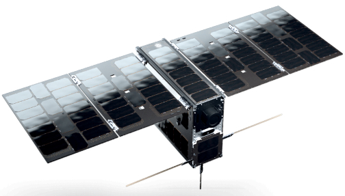
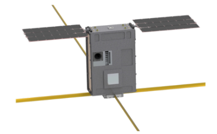
AAC Clyde Space’s EPIC 6U smallsat platform.

The new 6U smallsat will carry OMS’s next generation, miniaturized, microwave radiometer as a part of the company’s Global Environmental Monitoring System (GEMS) constellation of satellites. The radiometer will monitor 118GHz and 183GHz frequency bands to gather temperature and humidity measurements at multiple altitudes as it orbits the earth.

According to the firm, GEMS is a groundbreaking Earth Observation (EO) solution which uses passive microwave soundings to record temperature and humidity at multiple altitudes regardless of cloud cover. The measurements can provide identification of precipitation type and density at altitude as well. The data collected by GEMS satellites magnifies the volume of microwave soundings available from government satellites and improves the precision and clarity of weather forecasts across the globe.


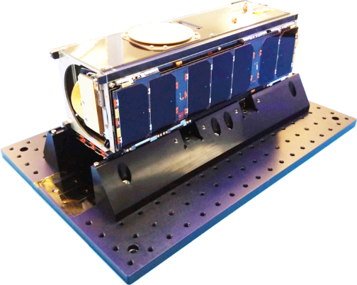
Orbital Micro Systems IOD-1 GEMS 3U demonstration satellite deployed 3 July 2019.

Access to the unique GEMS data is available through OMS’ International Center for Earth Data (ICED) located in Edinburgh, Scotland. Data from the IOD-1 GEMS satellite is currently provided to government and commercial entities, including the aviation and maritime sectors, as well as insurance and government organizations. When it achieves full deployment with some 50 satellites, the GEMS constellation will deliver near real-time data for any point on earth at approximately 15-minute intervals.


William Hosack

William Hosack, CEO for OMS, said the company is delighted to, once again, work with Clyde Space, and leverage their expertise and commitment to engineering outstanding bus products. Clyde Space shares in OMS’s vision in leveraging space technology for improving weather observation capabilities on Earth. The firm looks forward to working even closer with Clyde Space to deliver essential weather data to commercial and government organizations worldwide.

For more information about Orbital Micro Systems, please visit .

Filed Under: News

NASA to Study the Sun with Six Smallsats

April 2, 2020 by editorial

NASA has selected a new mission to study how the Sun generates and releases giant space weather storms – known as solar particle storms – into planetary space.

This information improve understanding of how our solar system works as well as, ultimately, helping to protect astronauts traveling to the Moon and Mars by providing better information on how the Sun’s radiation affects the space environment they must travel through.


A new NASA mission called SunRISE will study what drives solar particle storms – giant surges of solar particles that erupt off of the Sun – as depicted in this illustration. Understanding how such storms affect interplanetary space can help protect spacecraft and astronauts. Image is courtesy of NASA.

The new mission, called the Sun Radio Interferometer Space Experiment (SunRISE), is an array of six cubesats operating as one very large radio telescope. NASA has awarded $62.6 million to design, build and launch SunRISE by no earlier than July 1, 2023.

NASA chose SunRISE in August 2017 as one of two Mission of Opportunity proposals to conduct an 11-month mission concept study. In February 2019, the agency approved a continued formulation study of the mission for an additional year. SunRISE is led by Justin Kasper at the University of Michigan in Ann Arbor and managed by NASA’s Jet Propulsion Laboratory (JPL) in Pasadena, California.

The mission design relies on six solar-powered cubesats – each about the size of a toaster oven – to simultaneously observe radio images of low-frequency emission from solar activity and share them via NASA’s Deep Space Network. The constellation of cubesats would fly within 6 miles of each other, above Earth’s atmosphere, which otherwise blocks the radio signals SunRISE will observe.

Together, the six smallsats will create 3D maps to pinpoint where giant particle bursts originate on the Sun and how they evolve as they expand outward into space. This, in turn, will help determine what initiates and accelerates these giant jets of radiation. The six individual spacecraft will also work together to map, for the first time, the pattern of magnetic field lines reaching from the Sun out into interplanetary space.


NASA JPL artistic rendition of a SunRISE smallsat.

NASA’s Missions of Opportunity maximize science return by pairing new, relatively inexpensive missions with launches on spacecraft already approved and preparing to go into space. SunRISE proposed an approach for access to space as a hosted rideshare on a commercial satellite provided by Maxar of Westminster, Colorado, and built with a Payload Orbital Delivery System, or PODS. Once in orbit, the host spacecraft will deploy the six SunRISE spacecraft and then continue its prime mission.

Missions of Opportunity are part of the Explorers Program, which is the oldest, continuous, NASA program designed to provide frequent, low-cost access to space using principal investigator-led space science investigations relevant to the Science Mission Directorate’s (SMD) astrophysics and heliophysics programs. The program is managed by NASA’s Goddard Space Flight Center in Greenbelt, Maryland, for SMD, which conducts a wide variety of research and scientific exploration programs for Earth studies, space weather, the solar system and universe.

Nicky Fox, Director of NASA’s Heliophysics Division, said the agency is so pleased to add a new mission to the fleet of spacecraft that help to gain better understand of the Sun, as well as how the star influences the space environment between planets. The more that is known about how the Sun erupts with space weather events, the more their effects on spacecraft and astronauts can be mitigated.

Filed Under: Featured, News

Consortium Plans to Launch in 2022 the First, Global, VDES Satellite Network

April 2, 2020 by editorial

A newly established consortium is going to develop a network for LEO satellites delivering ice chart data to ships at sea.

This will significantly improve navigation for ships in rough seas and raise security for the crew on board. The network will also allow the satellite operator Sternula to launch its first of a total of 50 smallsats.

A new research project called MARIOT (Maritime IoT) is going to develop a LEO satellite network based on the new VDES (VHF Data Exchange System) technology. The network will be the first of its kind and establish a stable, low-cost data connection for maritime safety and navigation services. The consortium behind the project is headed by the Danish satellite operator Sternula.

The SATCOM developers GateHouse, Space Inventor, and Satlab as well as Aalborg University, and the Danish Meteorological Institute also participate in the project which will initially focus on the need for improved communication and navigation services in the Arctic Ocean.

VDES technology is the second generation of the Automatic Identification System (AIS). Today, the AIS standard is used to monitor marine traffic by more than 200,000 ships. However, AIS has a limited reach of only 30 nautical miles and is also limited to transfer on only certain types of data. VDES will enable global connectivity through satellite networks as well as efficient transfer of more data types.

In addition to shipping companies operating in the Arctic Ocean, the VDES network is also relevant for maritime security and navigation services, e.g., for sailing directions and coastal monitoring, and can also be used by the maritime industry to monitor marine engines and critical equipment on board. The contribution from GateHouse is mainly related to data communication—more specifically, by ensuring that data can be communicated to and from the individual satellites to the ground station. This includes inter-satellite capabilities and advanced algorithms for data routing in satellite constellations.

GateHouse, Space Inventor, and Satlab will develop the hardware and software components for the project while Aalborg University―based on its extensive experience with launching smallsats―will contribute with technology and expert knowledge. The Danish Meteorological Institute will participate with their ice chart service, which is in development and will be tailored to the VDES network. The MARIOT project will be managed by Sternula and is sponsored by the Danish Innovation Fund.


Per Koch

Business Development Manager at GateHouse, Per Koch, said that, today, the satellite communication networks used by ships in high-latitude seas are often expensive, inept for small amounts of data, and, in some cases, do not even cover seas in remote regions. This is an issue―especially in the Arctic Ocean―where optimized navigation services can significantly reduce the length of shipping routes, e.g. by placing routes closer to the Arctic. VDES offers a faster and more efficient data connection compared to other SATCOM services on the market, and after the VDES standard was assigned global radio frequencies last year, the company now has the opportunity to launch the first global VDES network improving navigation services and security for ships sailing through treacherous passages

Filed Under: News

X2nSat Working with New Mexico State University Students on 2020 Pacific Cup Race SATCOM Project

April 2, 2020 by editorial

New Mexico State University’s College of Engineering and the Department of Biology are collaborating with X2nSat in order to create a device to measure Pacific Ocean temperatures in real time during the 2020 Pacific Cup race.

The Pacific Cup is a race that started in 1980 and now takes place every other year where sailors start from San Francisco and sail the open ocean to Hawaii’s Kaneohe island. The race is usually considered something sailors do for fun; however, this year NMSU and X2nSat want to put the boats to work.

The students at NMSU, as part of the Aggie Engineering Capstone Design Program, are working to design a device capable of measuring ocean temperatures at various depths that can also store and transmit data in real time via X2nSat’s satellite communications technology.

The NMSU team working on the sensor include mechanical engineering seniors Caleb Gustin, Joseph Moseley, Dominic Blea and Makena Sutherland, industrial engineering senior Ahmad Atiah and electrical engineering senior Rodion Shishkov. They are also being advised on the environmental impact of their project by Michelle Nishiguchi, Regents Professor and Biology department head at NSMU.

X2nSat is hoping to work with the students of NMSU to provide real-time accurate data for the entire 2,000 mile race. As well as being able to run live video updates, stream movies and videos, the firm hopes to show what satellites are capable of accomplishing.

This is something that has never been done previously – despite the likely importance of these readings, the funding and infrastructure needed in order to perform something of this magnitude had been out of reach. Now, though, with the help of X2nSat and satellite, the students of NMSU can measure ocean temperatures from San Francisco to Hawaii and build a case for environmental impact.

The Pacific Cup race will kick off the week of June 29, 2020, from San Francisco and will last anywhere from a quick six, to a leisurely 17 days, depending on how long it takes each boat to arrive.

Gabe Garcia, mechanical engineering associate professor and assistant dean of student success for experiential learning, said the project will promote partnership between NMSU students and industry. In addition, the project will demonstrate the capabilities of satellite communications over a specific region of the Pacific Ocean.

Undertaking this task from the X2nSat side is CEO Garrett Hill and the crew of the boat Big Medicine, Pete Whyte, Bryan Hill, Dominic Haugh, and Ian Chadwick in addition to X2nSat’s technical support (GNSC) crew and the engineering team.


Garrett Hill

Garrett Hill, the CEO of X2nSat, said that the company is always looking to test the capabilities of our communications. The firm believes that showing satellite’s ability to maintain live readings while in the middle of the Pacific ocean, thousands of miles from land, will be something incredible.

Filed Under: News

  • « Go to Previous Page
  • Go to page 1
  • Go to page 2
  • Go to page 3
  • Go to page 4

Primary Sidebar

WEEKLY NEWSLETTER

Archives

  • January 2021
  • December 2020
  • November 2020
  • October 2020
  • September 2020
  • August 2020
  • July 2020
  • June 2020
  • May 2020
  • April 2020
  • March 2020
  • February 2020
  • January 2020
  • December 2019
  • November 2019
  • October 2019

© 2019–2021 SatNews

x
Sign Up Now!

Enjoy a free weekly newsletter with recent headlines from the global SmallSat industry.

Invalid email address
We promise not to spam you. You can unsubscribe at any time.
Thanks for subscribing! You will now receive weekly SmallSat News updates.
We love our advertisers.
And you will too!

Please disable Ad Blocker to continue... We promise to keep it unobtrusive.
We promise not to spam you. You can unsubscribe at any time.
Invalid email address
Thanks for subscribing! Please check your email for further instructions.