• Skip to main content
  • Skip to primary sidebar
  • Home
  • News
  • Featured
  • More News ⌄
    • SatNews
    • SatMagazine
    • MilSatMagazine
  • Events ⌄
    • MilSat Symposium
    • SmallSat Symposium
    • Satellite Innovation
  • Contacts
  • SUBSCRIPTION

SmallSat News

You are here: Home / Archives for Featured

Featured

Smallspark Space Systems and Leaf Space Initiate Partnership

July 14, 2020 by editorial

Smallspark Space Systems has entered into an agreement with Leaf Space, an Italian provider of ground segment services to satellite operators and launchers, to bring ground station services to UK Government and private sector clients.

Smallspark and Leaf Space plan for a partnership that will deliver joint bids for projects with the UK Government and other commercial operators in the UK , with the aim of becoming the primary contractor for services related to supporting the UK governments ambitions with OneWeb, the proposed 650-satellite constellation that will provide worldwide satellite internet and broadband services to people across the globe.

This major proposed collaboration changes the landscape of UK aerospace, with both companies working together to provide UK-based services for OneWeb, including the development of new, low-cost, rapidly deployable ground stations, expansion of ground segment coverage to new geographies as well as operating and maintaining OneWeb’s existing ground station networks.

If successful, the bid will kickstart rapid development across the space value chain, creating new skilled jobs, providing massive opportunities for investment across the sector, with new sites proposed across the country, and exploring the potential of manufacturing opportunities in the UK.

Leaf Key is a ‘ground segment as a service’ solution for satellite operators.

Executive Comments

Commenting on this agreement, Joe Ward, CEO of Smallspark Space Systems said, “Working with Leaf Space is an exciting opportunity for both Smallspark and UK Space as a whole; with the UK’s goals of dramatically expanding its reach into space, we’re keen to help support the governments ambitions wherever possible. With both satellite constellations and native launch capabilities, it is essential the UK has reliable, agile ground station services to support applications requiring high bandwidth & low latency communications, driven by adoption of 5G technologies via terrestrial & satellite networks. Italy has always been a pioneer in the global space market, and we’re thrilled to lead the path to strengthen UK-Italy ties.”

Jai Dialani, Sr. Business Developer on behalf of Leaf Space, noted, “Partnership with Smallspark Space Systems is a valuable opportunity for our company to start a collaboration with a pioneering launch service provider. We will provide an immediately available ground segment service capability to broaden their portfolio. This will help potential customers find a complete solution for their missions, assuring a reliable and consistent end-to-end service. Thanks to the continuous work effort to expand and develop our products, customers will be able to find a ground segment solution in the early stages of the mission while choosing Smallspark Space Systems launch solutions, also providing an easier and quicker commissioning phase for their satellites.”

Dialani added, “Leaf Space has been offering tailored ground segment services to its customers, including Launch and Early Operations (LEOPS), daily passes, pass distribution and operational conditions, resulting in a perfect solution for in-orbit demonstrations (IOD) or other missions such as serving broadband constellations requiring high contact time and low latency, typical elements of our distributed ground station network.”, added Jai, “ The proprietary ground segment infrastructure provides redundancy and reliability during the LEOP mission phase, and the versatile service can be easily integrated into third-party service bundles. The two companies are planning to conduct integration and testing activities that will ensure the ground segment service provision is operational on a rapid schedule before OneWebs’ satellite launches.”

Filed Under: Featured, News

OneWeb Sale Approved by US Bankruptcy Court + Avanti Layoffs

July 14, 2020 by editorial

OneWeb is now well on its way to being purchased by a joint-venture between the UK government and India telco Bharti Global.

A US bankruptcy court approved the sale of OneWeb to the consortium on July 10th in return for a guaranteed $1 billion sum, which will be paid 50/50 by the UK and Bharti.

OneWeb issued a statement in which the firm stated, “The parties will work to complete the plan sale process, including filing our plan and disclosure statements with the court, conducting voting with our creditors, and seeking regulatory approval and completing customary closing conditions, and expect the process to be completed by the fourth quarter of 2020.”

The UK/Bharti rescue plan presented to the New York court provides about $640 million to take the business forward – after various settlement costs are deducted.

There are other hurdles to overcome, including regulatory approvals, although the parties stress they do not see serious obstacles ahead.

Meanwhile, the bankruptcy court dealt on July 10th with a slew of other matters relating to the OneWeb bankruptcy. The firm’s ‘debtor in possession’ authorization was extended — that allows OneWeb to continue in business. One important aspect was OneWeb’s relationship with the existing joint-venture with Airbus in Airbus OneWeb Satellite, which has been building OneWeb’s satellites at a Florida factory.

The court permitted OneWeb to enter into an agreement with the satellite arm of the business and pay an advance sum of $50.7 million for the purchase of satellites.

The Court also received OneWeb’s next 13-week budget of $92.25 million in expenditure plus a further $29 million in costs relating to the restructuring of the company. The court has also approved periodic financing to flow into ‘new’ OneWeb from the buyers as part of the company’s restructuring and transition out of bankruptcy.

In additional news, Arqiva, the UK broadcast transmission and cellular mast operator, is reportedly planning to lay off about a third of its employees, according to a report in the Daily Telegraph.

The report stated that the company, which is in the end-stages of selling its cellular mast division, is planning a radical restructuring that would see more than 500 of the firm’s staff made redundant.

Arqiva is owned by a consortium led by PSP Investments and the Canada Pension Plan Investment Board (48 percent) along with Australian fund manager and 25 percent by investment bank Macquarie (via its Macquarie European Infrastructure Fund). However, a £2 billion sale of Arqiva’s cellular towers business to Spain’s Cellnex Telecom has been passed by the UK’s Competition & Markets Authority in April. The sale to Cellnex is expected to close during this quarter.

Recently, Arqiva appointed a new CEO in Paul Donovan, an existing board member, and who took over that position on June 30th.

Arqiva retains its important broadcast TV and radio division, along with media playout, satellite teleports and uplinking and asset management businesses.

Reports by journalist Chris Forrester, filing at the Advanced Television infosite...

Filed Under: Featured, News

Ten Successful Years for Kongsberg’s AISSAT-1

July 10, 2020 by editorial

AISSat-1 signals captured over a 1,250 day period of time.
Image is courtesy of the Norwegian Defence Research Establishment.

KONGSBERG is celebrating 10 successful years since the AISSat-1 AIS-receiving satellite, complete with its KONGSBERG AIS payload, was launched from the Satish Dhawan Space Centre in India on July 12, 2010.

The game-changing AISSat-1, the first operational AIS receiver in space, is financed by the Norwegian Ministry of Trade and Industry and deploys technology which was developed collaboratively by Kongsberg Seatex with the Norwegian Space Centre, the Norwegian Defence Research Establishment and the Norwegian Coastal Administration.

Launched via an Indian PSLV rocket, the 20 x 20 x 20 cm, 6 kg, cube-shaped AISSat-1 smallsat has been maintaining an SSO polar orbit at an altitude of approximately 635 km for a full decade now, receiving AIS messages from ships all over the globe and transmitting them to Earth via Kongsberg Satellite Services’ Svalbard-based ground station.

While the 10th anniversary of the AISSat-1 launch is justifiable cause for celebration, KONGSBERG is nevertheless firmly focused on the future. KONGSBERG’s status as a driver of constantly evolving technologies has positioned the company as a key player in the development of the next-generation VDES (VHF Data Exchange System) payload. Visualized as an extension to AIS, this robust, narrow-band, high-speed, two-way VHF ship communications system will establish a global standard designed to support the transformative digitalization of the maritime community. Accordingly, next-generation AIS equipment for commercial shipping will incorporate both AIS and VDES in the same unit.

While the 10th anniversary of the AISSat-1 launch is justifiable cause for celebration, KONGSBERG is nevertheless firmly focused on the future. KONGSBERG’s status as a driver of constantly evolving technologies has positioned the company as a key player in the development of the next-generation VDES (VHF Data Exchange System) payload. Visualized as an extension to AIS, this robust, narrow-band, high-speed, two-way VHF ship communications system will establish a global standard designed to support the transformative digitalization of the maritime community. Accordingly, next-generation AIS equipment for commercial shipping will incorporate both AIS and VDES in the same unit.

Executive Comments

Arve Dimmen, Director of Maritime Safety at the Norwegian Coastal Administration, still marvels at the radical difference the AISSat-1 made to the supervision of shipping in the high north once it entered service.“It was almost like ‘turning on the light,’ he recalls, “as the satellite enabled us to get a much better overview of the marine traffic in our sea areas. The satellite data is distributed to several public authorities: Joint Rescue Coordination Centers, the Coast Guard and the Norwegian Directorate of Fisheries are among some of the most frequent users. The data can be used to monitor fishing activities and to monitor search and rescue operations at sea. AISSat-1 was the starting point of our satellite program for maritime surveillance, and it has been a great success.”

“The 10th anniversary of successful AISSat-1 service, together with a wide range of additional, successful missions in the past decade, have definitely demonstrated that we have taken a lead in innovative space payload solutions for maritime applications,” added Gard Ueland, President, Kongsberg Seatex. “These missions show that, with a NewSpace approach, it is possible to establish highly successful and cost-efficient space infrastructures using micro and nano satellites. VDES represents a bold step forward in the efficient monitoring and management of vessel traffic, leading to greatly enhanced safety on board and in ports. With the ongoing overhaul of the AIS infrastructure both at sea and on land, we can expect to see a substantial uptake of VDES services over the next years.”

Artistic rendition of the AISSat-1 smallsat.

Filed Under: Featured, News

Satnews Perspectives Video Interview with Daniel L. Jablonsky, President and CEO, Maxar Technologies

July 8, 2020 by minisat

Daniel L. Jablonsky was appointed to the role of President and Chief Executive Officer of Maxar Technologies and to the Company’s Board of Directors on January 13, 2019.

Previously, Mr. Jablonsky had served as President of DigitalGlobe since October 2017, when the company became part of Maxar Technologies. He joined DigitalGlobe in 2012 as Senior Vice President, General Counsel and Corporate Secretary, and also held the role of General Manager, International Defense & Intelligence from 2015 to 2017.

Prior to DigitalGlobe, Mr. Jablonsky was a shareholder at the law firm of Brownstein, Hyatt, Farber, Schreck, LLP from 2011 to March 2012, where he practiced corporate and securities law. From 2010 to 2011, Mr. Jablonsky served as the Interim Co-General Counsel of Flextronics International Ltd., and from 2007 to 2010, he held the role of Senior Corporate Counsel, Securities and Mergers & Acquisitions at Flextronics.

Mr. Jablonsky previously was in-house counsel at UBS Financial Services, Inc., served in the enforcement division of the U.S. Securities and Exchange Commission, and practiced corporate and securities law with O’Melveny & Myers LLP. Mr. Jablonsky holds a Bachelor of Science in Mechanical Engineering from the United States Naval Academy and a Juris Doctor degree from the University of Washington School of Law. Prior to law school, Mr. Jablonsky was an officer and nuclear engineer in the U.S. Navy.

Filed Under: Featured, News

L3Harris Launches USAF Constellation Demo Smallsat

July 6, 2020 by editorial

L3Harris Technologies (NYSE:LHX) launched the latest in a demonstration series of end-to-end smallsats as part of a U.S. Air Force constellation the company is responsible for developing.

As the prime contractor for the firm fixed-price development space mission, L3Harris is designing, developing, building, testing and deploying the satellites. The company will task, command and control the satellite system, as well as perform on-board processing of data to deliver imagery products directly to warfighters on tactical timelines.

The Evolved Expendable Launch Vehicles Secondary Payload Adapter, or ESPA-class, satellite system will use L3Harris’ fully reprogrammable payload platform — allowing operators to reconfigure smallsat payloads on orbit to changing missions.

The company’s High Compaction Ratio unfurlable X-band reflector is also on board to enable high-speed data communication.

Ed Zoiss

“L3Harris has developed and supported various aspects of satellite missions over the last several decades as a component supplier or hosted payload,” said Ed Zoiss, President, Space and Airborne Systems, L3Harris. “In collaboration with the U.S. Air Force, we pulled the pieces together to successfully plan, develop and execute an affordable, high-performance space mission, which is part of a responsive constellation contract.”

Filed Under: Featured, News

Telesat Also Wants OneWeb’s Satellites??

July 1, 2020 by editorial

Ottawa-based Telesat has reportedly entered a bid for OneWeb’s satellite assets. But it isn’t alone.

There will be an auction process on July 2nd in New York. The UK is widely reported to have committed to a $500 million (£405 million) participation for a 20 percent stake in OneWeb. The UK bid is said to be backed by India’s Bharti Telecom and its Bharti Airtel division, owned by billionaire Sunil Mittal. In fact, it is also reported that Telesat had hoped to partner with UK interests on a bid.

Bharti was already a backer and investor in OneWeb (now in bankruptcy protection) alongside other key players such as chip-maker Qualcomm and Europe’s Airbus. OneWeb’s major backer was Japanese media conglomerate SoftBank.

Bharti is a huge Indian company and the nation’s second-biggest wireless operator. Its market value is about $41 billion, and as part of its investment in OneWeb it had the distribution rights to its broadband services and as well as India covering Bangladesh, Sri Lanka and Africa.

Airbus has a very special interest in the bankruptcy and its outcome. First up, it is a 50/50 shareholder with OneWeb in the Florida factory turning out OneWeb’s satellites.

OneWeb has 68 working satellites in orbit out of a total initial plan of at least 648 with each operating at 1200 kms altitude. The OneWeb/Airbus joint venture, prior to the bankruptcy, was making two satellites a day from its facility in Florida.

However, there are also rumors that Telesat and Airbus, and possibly including Thales Alenia Spac,e are also interested in OneWeb’s assets. With Europe’s two important satellite-building companies interested, and a possibility that the European Commission might back a French bid – with Telesat – and which includes satellite operator Eutelsat. Eutelsat is alone among the ‘big four’ satellite operators in NOT having a LEO component.

Canada’s Telesat is also a very keen fan of LEO satellites. Telesat is the fourth-largest geostationary satellite operator and supplies DTH TV signals of some 200 channels for the likes of Bell TV and Shaw Direct. It operates the Anik, Nimiq and Telstar fleets of satellites.

It has recently tested its own debut LEO satellites in an exercise with Telefonica. The tests, described by the pair as “rigorous” were designed to explore the performance and feasibility of leveraging LEO satellites for high-end services. Testing demonstrated that Telesat LEO could be a viable option for wireless backhaul and presents a substantial improvement in performance over geostationary orbit (GEO) links.

Those tests included the delivery of HD video streaming and video conferencing as well as VPN connections. Telesat was planning to launch just 117 LEO satellites into orbit. That plan was expanded to 298 craft and in May, Telesat announced that it would like FCC permission to dramatically extend that number to an overall 1671 satellites.

Telesat’s bid – if accepted – could be the ‘fast-track’ to launching its own LEO fleet. For example, it could trim the OneWeb planned fleet to suit the Canadian company’s own purposes.

Chris Forrester

Article posted by journalist Chris Forrester at the
Advanced Television infosite.
Chris is also a Senior Contributor for Satnews Publishers.

Filed Under: Featured, News

Global Dark Ship Detection With HawkEye 360’s New Radar Signals Capabilities

July 1, 2020 by editorial

HawkEye 360 Inc. has announced that the company’s flagship RFGeo product can now map an expanded catalog of marine navigation radar signals to further improve global maritime situational awareness.

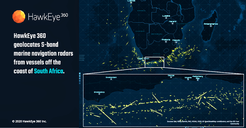
With this update, HawkEye 360 introduces the first S-band radar signal and quadruples the number of X-band radar signals in the company’s library. HawkEye 360 can now cover the most used frequencies for X-band magnetron-based radar systems, providing a more comprehensive view of maritime activity.

Vessels continuously operate marine radars to safely navigate from point to point and avoid nearby obstacles, making them an excellent means to track vessels that have otherwise ceased AIS transmissions and gone dark. Commercial vessels 300 gross tonnage or larger are required to be equipped with X-band radars (9 GHz).

The largest vessels also carry S-band radars (3 GHz) to penetrate deeper through rain or fog. Each new signal improves Hawkeye 360’s ability to develop vessel profiles. This data helps clients identify dark vessels that might be involved in illicit activities, such as smuggling or illegal fishing.

HawkEye 360’s RFGeo identifies and geolocates RF signals collected by HawkEye 360’s proprietary satellite constellation. RFGeo is the first commercially available product offering global spectrum awareness across a broad range of radio signals.

In addition to the newly announced signals, RFGeo can independently geolocate marine VHF marine radios, UHF push-to-talk radios, L-band mobile satellite devices, EPIRB marine emergency distress beacons, and vessel Automatic Identification Systems (AIS). HawkEye 360 is continually adding signals to the catalog to broaden the reach of RF identification across land, sea, and air domains.

Executive Comments

John Serafini

“We’re addressing critical gaps in Maritime Domain Awareness by revealing an entirely new data layer for vessel monitoring,” said John Serafini, Chief Executive Officer, HawkEye 360. “We’re excited to introduce our first signal in the S-band frequencies. By expanding our signal catalog, we’re not just collecting new and diverse RF data sets, we’re providing actionable intelligence to support the increasing number and scale of our customers’ missions.”

“Our customers need to maintain accurate and consistent visibility of vessels,” said Alex Fox, EVP for Business Development, Sales and Marketing, HawkEye 360. “Vessels are continuing to evade AIS detection to conduct illicit activities, making it difficult for organizations to identify and monitor their behaviors. We’re able to provide unique data sets that enable our customers to keep their finger on the pulse of vessel activity.”

Recent HawkEye 360 news…

HawkEye 360’s Keen Eye Adds More Defense Industry Expertise to their
Board of Directors

HawkEye 360 Reveals Iranian Tankers Evading Sanctions

Filed Under: Featured, News

Ball Selected by NOAA for Four Weather Study Contracts

June 30, 2020 by editorial

Ball Aerospace was selected by the National Oceanic and Atmospheric Administration (NOAA) for four, six-month study contracts that will inform mission, spacecraft and instrument concepts for future operational weather architectures and Earth observation capabilities. Ball Aerospace is also collaborating on a fifth study contract awarded to L3Harris Technologies.

The five study contracts include:

  • Auroral Imager in Tundra – Ball is working with Computational Physics, Inc. to perform a trade study of cost and performance between two promising technology strategies for a dedicated auroral imager in a highly elliptical Tundra orbit, long recognized as a useful vantage point for global auroral imaging. Auroral imagery provides important space weather situational awareness for users of technologies affected by auroral phenomena, such as power grids and aviation services.
  • Ball Operational Weather Instrument Evolution (BOWIE) Microwave – This concept study will evaluate the baseline design of Ball’s BOWIE-M instrument and explore optimization of performance and cost. BOWIE-M leverages recent advances in microwave component miniaturization and advances in antenna technology to enable a future disaggregated constellation of low-cost, high-performance atmospheric sounding instruments. Approximately half the size of current instruments flying on operational polar-orbiting weather satellites, BOWIE-M is designed to deliver similar capability at reduced cost. Ball is collaborating with Atmospheric and Environmental Research (AER), a Verisk business, that will lead a trade analysis of the instrument design and performance.
  • BOWIE Compact Hyperspectral Infrared Observations (CHIRO) – This instrument concept study will focus on technology and performance trades for a cost-effective, high-performance smallsat solution for hyperspectral infrared sounding from geostationary orbit. BOWIE Low-Earth Orbit (LEO) IR Sounder – Through this study, Ball will explore compact instrument designs to meet NOAA’s atmospheric vertical temperature and moisture profiling requirements, identifying technology roadmap options to address cost versus performance for infrared sounder instrument(s) for rapid insertion into Low-Earth Orbit.
  • Joint LEO Sounding Mission Study – Ball is working with L3Harris and PlanetiQ for this mission concept study, which will evaluate an all-industry smallsat mission, hosting both microwave and infrared sounding instruments (provided by Ball and L3Harris, respectively), and GNSS-RO sounding sensors (provided by PlanetiQ). The team will also explore how the mission can be optimized for cost and performance while meeting the LEO sounding requirements of NOAA’s future operational weather architecture. Ball will also perform an accommodation assessment of the baseline instrument designs, from all study participants, using a Ball small satellite for insertion in various orbits. In addition to an instrument integration assessment, Ball will study commercial launch options to enable a delivery-on-orbit acquisition model for a complete sounding system that NOAA would own and operate.
Dr. Makenzie Lystrup

“Operational weather satellites are a critical part of the nation’s infrastructure, playing a key role in keeping the public safe and the economy strong by enabling forecasters to predict and reduce the impacts of extreme weather events,” said Dr. Makenzie Lystrup, VP and GM, Civil Space, Ball Aerospace. “Through close coordination with the broader weather community, Ball developed a series of innovative technology and mission solutions to meet NOAA’s most critical space-based observational needs in an affordable and sustainable way, and these studies are a continuation of this effort.”

Recent Ball Aerospace news…

Anokiwave and Ball Aerospace Add Ku-Band Option to Phased Array Antennas

Ball Aerospace Initiating the Manufacturing of the USAF SMC’s WSF Satellite Following Successful CDR

Filed Under: Featured, News

Perspectives Video Interview with Stephen Jurczyk, Associate Administrator, NASA

June 26, 2020 by minisat

Speaking of the DEMO-2 mission to the ISS, I’m very proud of the NASA and Space X team and the courage of Bob Behnken and Doug Hurley. This event was something for the nation and world to rally around during these challenging times.

– Stephen Jurczyk

Mr. Stephen Jurczyk became NASA’s associate administrator, the agency’s highest-ranking civil servant position, effective May, 2018. Prior to this assignment he was the associate administrator of the Space Technology Mission Directorate, effective since June, 2015.  In this position he formulated and executed the agency’s Space Technology programs, focusing on developing and demonstrating transformative technologies for human and robotic exploration of the solar system in partnership with industry and academia.

He previously was Director at NASA’s Langley Research Center in Hampton, VA. Named to this position in May 2014, he headed NASA’s first field Center, which plays a critical role in NASA’s aeronautics research, exploration and science missions.  Jurczyk served as Langley’s Deputy Center Director from August 2006 until his appointment as director.

Jurczyk began his NASA career in 1988 at Langley in the Electronic Systems Branch as a design and integration & test engineer developing several space-based Earth remote sensing systems.  From 2002 to 2004 Jurczyk was director of engineering, and from 2004 to 2006 he was director of research and technology at Langley where he led the organizations’ contributions to a broad range of research, technology and engineering disciplines contributing to all NASA mission areas.

Jurczyk received several awards during his NASA career, including two NASA Outstanding Leadership Medals, the Presidential Rank Award for Meritorious Executive in 2006, and the Presidential Rank Award for Distinguished Executive in 2016 — the highest honors attainable for federal government leadership.

Jurczyk is a graduate of the University of Virginia where he received Bachelor of Science and Master of Science degrees in Electrical Engineering in 1984 and 1986.  He is an associate fellow of the American Institute of Aeronautics and Astronautics.

Filed Under: Featured, News

New HawkEye 360 Radar Signals Can Now Deliver Comprehensive Maritime Awareness

June 25, 2020 by editorial

HawkEye 360 Inc. has announced that the company’s flagship RFGeo product can now map an expanded catalog of marine navigation radar signals to further improve global maritime situational awareness.

With this update, HawkEye 360 introduces the first S-band radar signal and quadruples the number of X-band radar signals in the company’s library. HawkEye 360 can now cover the most used frequencies for X-band magnetron-based radar systems, providing a more comprehensive view of maritime activity.

Vessels continuously operate marine radar to avoid nearby obstacles and safely navigate from point to point, making it an excellent signal to track vessels that have otherwise ceased AIS transmissions and gone dark. Commercial vessels 300 gross tonnage or larger are required to be equipped with X-band radars (9 GHz). The largest vessels also carry S-band radars (3 GHz) to penetrate deeper through rain or fog. Each new signal improves HawkEye 360’s ability to develop vessel profiles and help clients identify dark vessels that might be involved in illicit activities, such as smuggling or illegal fishing.

HawkEye 360’s RFGeo identifies and geolocates RF signals collected by HawkEye 360’s proprietary satellite constellation. RFGeo is the first commercially available product offering global spectrum awareness across a broad range of radio signals. In addition to the newly announced signals, RFGeo can independently geolocate VHF marine radios, UHF push-to-talk radios, L-band mobile satellite devices, EPIRB emergency distress beacons, and vessel Automatic Identification Systems (AIS). HawkEye 360 is continually adding signals to the catalog to broaden the reach of RF identification across land, sea, and air domains.

Executive Comments

John Serafini

“We’re addressing critical gaps in Maritime Domain Awareness by revealing an entirely new data layer for vessel monitoring,” said John Serafini, CEO, HawkEye 360. “We’re excited to introduce our first signal in the S-band frequencies. By expanding our signal catalog, we’re not just collecting new and diverse RF data sets, we’re providing actionable intelligence to support the increasing number and scale of our customers’ missions.”

“Our customers need to maintain accurate and consistent visibility of vessels,” said Alex Fox, EVP for Business Development, Sales and Marketing, HawkEye 360. “Vessels are continuing to evade AIS detection to conduct illicit activities, making it difficult for organizations to identify and monitor their behaviors. We’re able to provide unique data sets that enable our customers to keep their finger on the pulse of vessel activity.”

Recent HawkEye 360 news

HawkEye 360’s Keen Eye Adds More Defense Industry Expertise to their Board of Directors

HawkEye 360 Reveals Iranian Tankers Evading Sanctions

HawkEye 360 Reveals Coronavirus Effect on Italy’s Maritime Sector

Filed Under: Featured, News

  • « Go to Previous Page
  • Page 1
  • Interim pages omitted …
  • Page 53
  • Page 54
  • Page 55
  • Page 56
  • Page 57
  • Interim pages omitted …
  • Page 61
  • Go to Next Page »

Primary Sidebar

WEEKLY NEWSLETTER

Archives

  • September 2026
  • August 2026
  • July 2026
  • June 2026
  • May 2026
  • April 2026
  • March 2026
  • February 2026
  • January 2026
  • December 2025
  • November 2025
  • October 2025
  • September 2025
  • August 2025
  • July 2025
  • June 2025
  • May 2025
  • April 2025
  • March 2025
  • February 2025
  • January 2025
  • December 2024
  • November 2024
  • October 2024
  • September 2024
  • August 2024
  • July 2024
  • June 2024
  • May 2024
  • April 2024
  • March 2024
  • February 2024
  • January 2024
  • December 2023
  • November 2023
  • October 2023
  • September 2023
  • August 2023
  • July 2023
  • June 2023
  • May 2023
  • April 2023
  • March 2023
  • February 2023
  • January 2023
  • December 2022
  • November 2022
  • October 2022
  • September 2022
  • August 2022
  • July 2022
  • June 2022
  • May 2022
  • April 2022
  • March 2022
  • February 2022
  • January 2022
  • December 2021
  • November 2021
  • October 2021
  • September 2021
  • August 2021
  • July 2021
  • June 2021
  • May 2021
  • April 2021
  • March 2021
  • February 2021
  • January 2021
  • December 2020
  • November 2020
  • October 2020
  • September 2020
  • August 2020
  • July 2020
  • June 2020
  • May 2020
  • April 2020
  • March 2020
  • February 2020
  • January 2020
  • December 2019
  • November 2019
  • October 2019

© 2019–2026 SatNews

Insert/edit link

Enter the destination URL

Or link to existing content

    No search term specified. Showing recent items. Search or use up and down arrow keys to select an item.
      x
      Sign Up Now!

      Enjoy a free weekly newsletter with recent headlines from the global SmallSat industry.

      Invalid email address
      We promise not to spam you. You can unsubscribe at any time.
      Thanks for subscribing! You will now receive weekly SmallSat News updates.
      We love our advertisers.
      And you will too!

      Please disable Ad Blocker to continue... We promise to keep it unobtrusive.
      We promise not to spam you. You can unsubscribe at any time.
      Invalid email address
      Thanks for subscribing!