• Skip to main content
  • Skip to primary sidebar
  • Home
  • News
  • Featured
  • More News ⌄
    • SatNews
    • SatMagazine
    • MilSatMagazine
  • Events ⌄
    • MilSat Symposium
    • SmallSat Symposium
    • Satellite Innovation
  • Contacts
  • SUBSCRIPTION

SmallSat News

You are here: Home / Archives for editorial

editorial

Airbus awarded Bundeswehr contract for MILSATCOM system + Sentinel-2C on the move

July 7, 2024 by editorial

Germany’s armed forces, the Bundeswehr, has awarded Airbus the SATCOMBw 3 prime contract for the next generation, secure, military satellite system that includes geostationary satellites as well as ground segment, launch and operation services for 15 years. The spacecraft are due to be deployed before the end of the decade and the contract value amounts to 2.1 billion euros.

Artistic rendition of the SATCOMBw 3 satellite on-orbit, courtesy of Airbus.

The contract covers the design, integration, test and on-orbit delivery of two, new, Airbus built ,military GEO telecommunications satellites that are the successor communications satellites to COMSATBw 1B and 2B. The contract also includes upgrading of the existing ground segment to operate the new satellites as well as operational services for 15 years, with the possibility of extension.

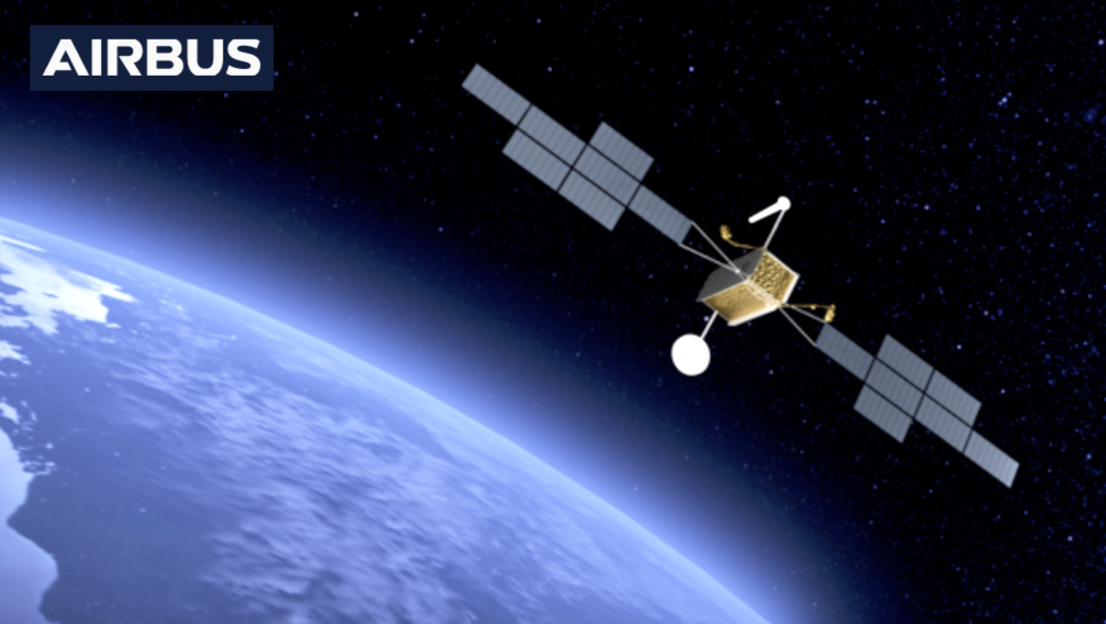
The new generation Airbus satellites are based on the Eurostar Neo platform and will weigh around 6 metric tons. They will have extensive capabilities to keep pace with the rapid changes in digitization and the constantly increasing volume of data transfer required. They will also feature the latest state of the art technologies. 

Photo of a Eurostar Neo platform, courtesy of Airbus.

A key element of the overall contract is an in-depth German value chain involving partners such as Bremen-based OHB and numerous smaller German companies. Central elements including the guidance and integration of the advanced payloads, the solar arrays and overall operation of the spacecraft will be from Germany. 

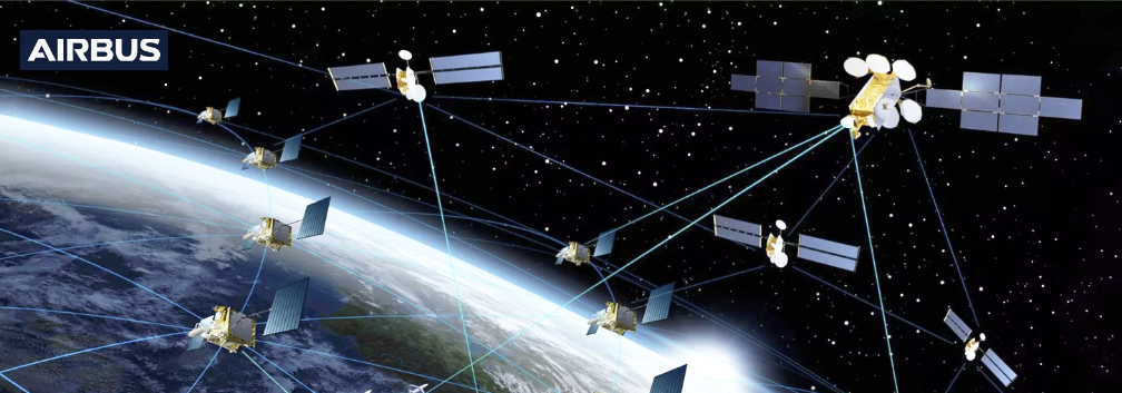
The Bundeswehr’s satellite communications system (SATCOMBw) is indispensable for autonomous and independently deployable communications and information services. It ensures the global command and information capability of the German armed forces, such as operational contingents and special forces. The SATCOMBw 3 project also aims to ensure that NATO’s North Atlantic Treaty Organisation commitments in this area will continue to be met in the future. With SATCOMBw 3, the Bundeswehr is responding to increased user requirements.

Michael Schoellhorn, CEO of Airbus Defence and Space, said, “After the success of the SATCOMBw Stage 2 program, which we have been delivering since 2009, this latest contract reinforces our strategic partnership with the Bundeswehr, providing them with a greatly enhanced secure milsatcom capability that is future proofed into the 2040s. At a time when Western democracies are challenged and where the European institutional space ecosystem is struggling, we are excited and grateful to develop and build this leading-edge system. Long term partnerships are crucial to guaranteeing essential sovereignty and capability, and protecting our armed forces in the increasingly unstable geo-political environment.”

Airbus built Copernicus Sentinel-2C climate satellite heading for launch site

Spacecraft to reach launch site on board sail-assisted Canopée ship. Photo courtesy of Airbus.

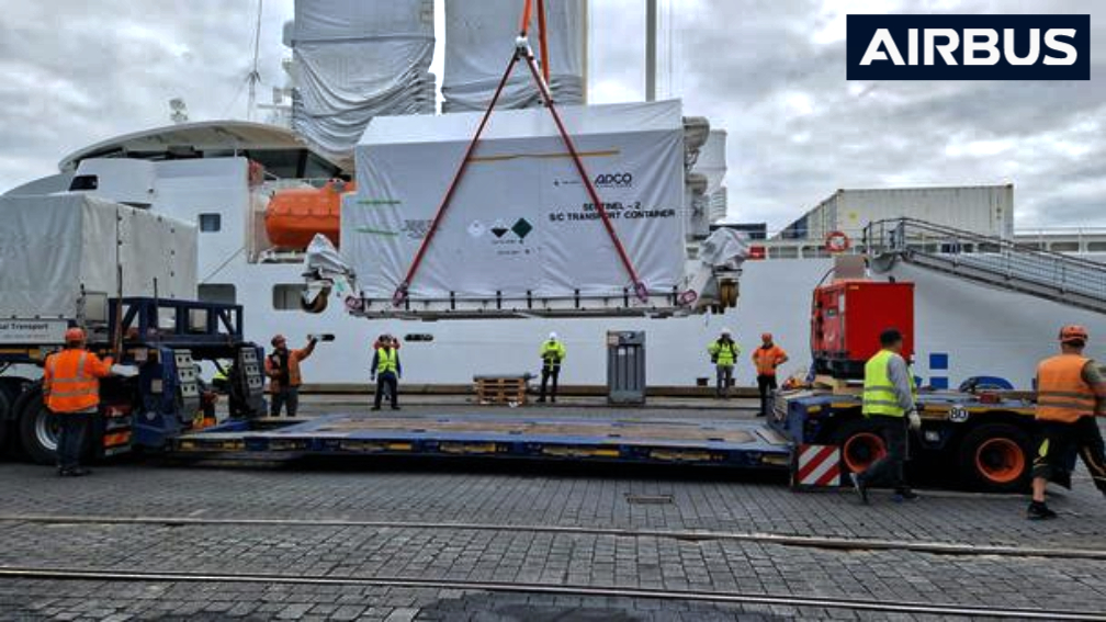
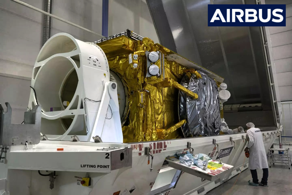
After road transport from Airbus in Friedrichshafen to Bremen, Germany, on July 2nd, the Airbus-built Sentinel-2C satellite, the third Copernicus Sentinel-2 satellite, is about to be shipped to the European spaceport in French Guiana.

Artistic rendition of the Sentinel-2C on-orbit.

The container has been loaded onto the iconic Canopée, the first sail-assisted cargo ship designed specifically to transport Ariane 6 rocket components from European ports to the Guiana Space Centre in Kourou, where it will arrive in approximately two weeks.

Photo of launch from the Guiana Space Center, courtesy of Arianespace.

Data collected by the Copernicus Sentinel-2 satellites is being used to monitor land use and change, soil sealing, land management, agriculture, forestry, natural disasters (floods, forest fires, landslides, volcanic eruptions and erosion) and to support humanitarian aid missions. Environmental monitoring, which provides information on the pollution of lakes and coastal waters, is also part of these activities, as is the monitoring of glaciers, ice and snow.

The Sentinel-2 mission contributes to the management of food security by providing information for the agricultural sector. Copernicus Sentinel-2, with its multispectral instrument, is the first optical Earth Observation (EO) mission of its kind to include three bands in the “red edge“, which provide key information on vegetation conditions. The satellite is designed to provide images that can be used to distinguish between different crop types, as well as data on numerous plant indices such as leaf area index, leaf chlorophyll content and leaf water content – all of which are essential for accurately monitoring plant growth.

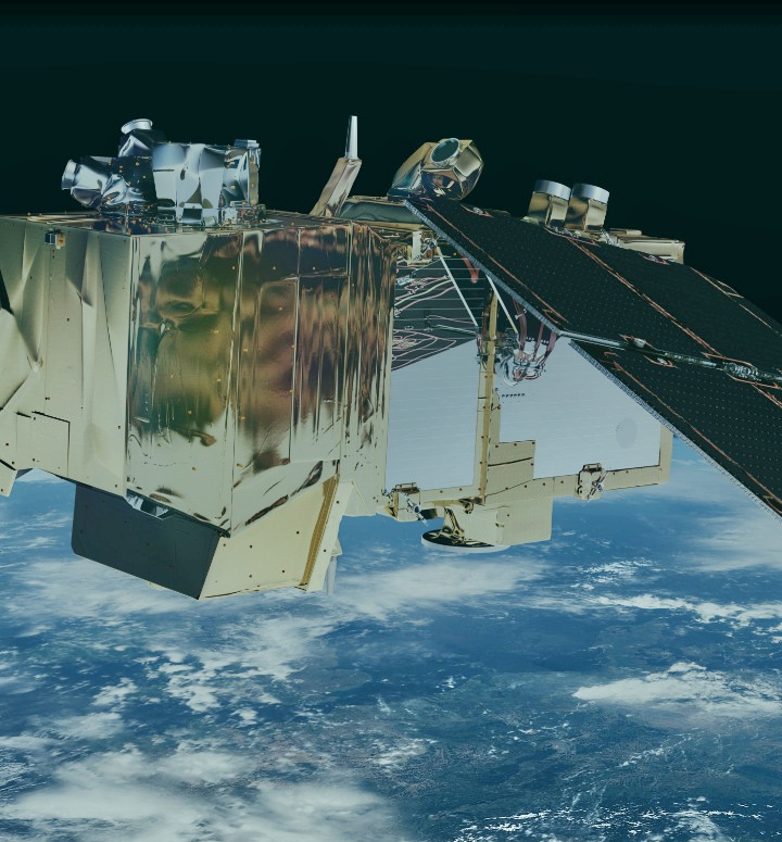
Sentinel-2C, like its predecessors Sentinel-2A and -2B, will provide “color vision” for Copernicus, the EO component of the EU Space Program, generating optical images from the visible to the shortwave infrared region of the electromagnetic spectrum. From an altitude of 786 kilometers, the 1.1 ton ‘C’ satellite will provide continuous imaging in 13 spectral bands with resolutions of 10, 20 or 60 meters and a uniquely large swath width of 290 kilometres. The optical design of the MultiSpectral Instrument (MSI) has been optimised to provide state-of-the-art image data quality over its very wide field of view, to be transmitted via Airbus’ laser-based SpaceDataHighway (EDRS).

SpaceDataHighway™ 
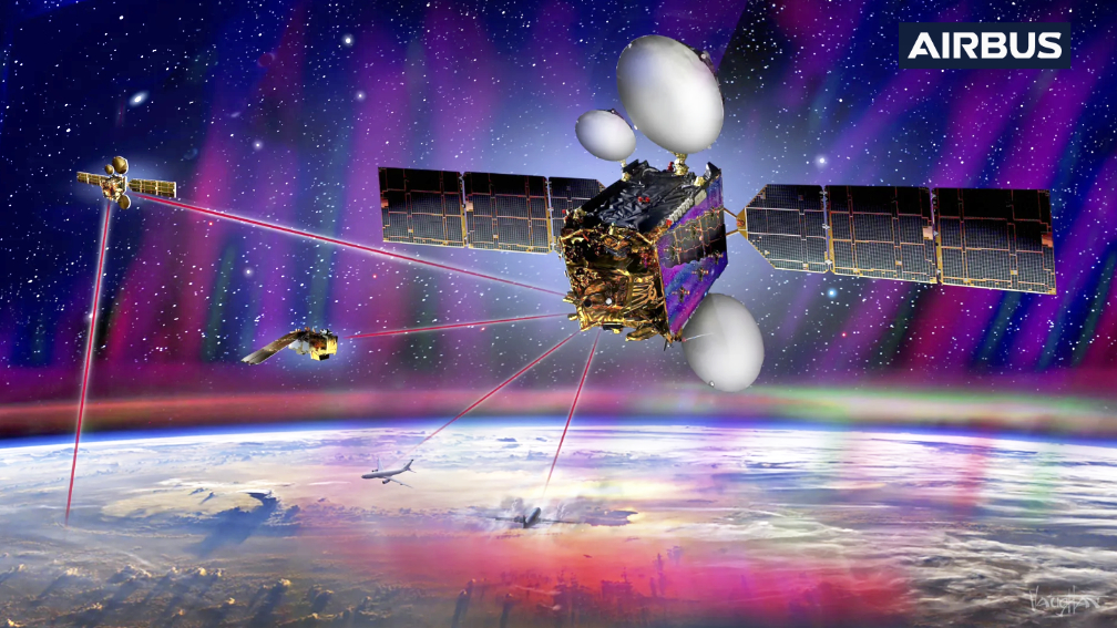
(SDH) is a public-private partnership between ESA (European Space Agency) and Airbus. The SpaceDataHighway service uses the Airbus-owned and operated European Data Relay System (EDRS) laser communication infrastructure to provide this high bandwidth capability for both LEO satellites and airborne platforms.

The telescope structure and mirrors are made of Silicon Carbide, a material pioneered by Airbus to provide very high optical stability and minimize thermo-elastic deformation, resulting in excellent geometric image quality. This is unprecedented in this category of optical imagers. Each Sentinel-2 satellite collects 1.5 terabytes per day after on-board compression. 

The Sentinel-2 mission is based on a constellation of two identical satellites, Sentinel-2A (launched in 2015) and Sentinel-2B (launched in 2017), flying in the same orbit but 180° apart to optimize coverage and revisit time. The satellites orbit the Earth every 100 minutes, covering all land surfaces, large islands, inland and coastal waters every five days. Once in orbit, Sentinel-2C will replace its predecessor, Sentinel-2A, while Sentinel-2D will later replace Sentinel-2B to ensure continuity of data beyond 2035.

The Sentinel-2 mission has been made possible through close cooperation among the European Commission, ESA, industry, service providers and data users. Some 60 companies have been involved in its development, led by Airbus Defence and Space in Germany.

Airbus has played a key role in building the satellites and instruments for Copernicus since the program began in 1998, contributing its environmental expertise to all six Sentinel missions and the new next-generation Copernicus satellites: CRISTAL, LSTM and ROSE-L.

The Sentinel satellites are part of Copernicus, the EO component of the EU Space Program, managed by the European Commission (EC) in partnership with the European Space Agency (ESA). The Copernicus Sentinels provide remote sensing data of the Earth, providing key operational services related to the environment and security.

Pre-launch activities will be carried out in Kourou to prepare Copernicus Sentinel-2C for launch on the final Vega rocket operated by Arianespace in September.

Copernicus Sentinel-2C - Copyright Airbus
Copernicus Sentinel-2C before loading into its container.
Photo is courtesy of Airbus.

“About half of the data used to assess and monitor the impact of climate change on Earth is actually delivered by satellites,” said Marc Steckling, Head of Earth Observation, Science and Exploration at Airbus. “The Copernicus Sentinel-2 satellites have provided valuable climate information to scientists since 2015 and Sentinel-2C will ensure continuity. Additionally, they have also made monitoring marine litter from space a reality, a significant achievement considering how critical this issue has become.”

Filed Under: News

BAE Systems intros the firm’s new Space Leadership team

July 7, 2024 by editorial

BAE Systems Digital Intelligence has established a new, integrated, Space Leadership Team and business unit.

From left to right – Ed Stevens, Matthew Angling, Kathryn O’Donnell, Richard Batchelor, Elaine Greaney, Doug Liddle and Elizabeth Seward
(Not pictured – Tony Holt, Sarah Parker and Markos Trichas)

Headed up by our newly appointed Director of Space, Doug Liddle, the team will bring together experienced senior leaders from across BAE Systems Digital Intelligence and In-Space Missions to advance our space strategy and deliver innovation in space for advantage on Earth.

Space technology helps us achieve incredible things. Scientists are making ground-breaking discoveries about the universe at a rapid pace – illustrated recently when the European Space Agency found water frost on Mars’ huge volcanoes. Back on Earth, space capability is becoming a core requirement for our customers across government, defence and commercial sectors in order to protect citizens, defend nations, predict natural disasters and more.

However, the importance of space to society is by no means new. For a long time now, technologies such as satellites have been interwoven everyone’s daily lives – take GPS in phones as just one example. At BAE Systems, the company has a long heritage of working in the sector. Over the past 20 years, the firm has delivered complex defence programs to help create a secure space domain, developing specialist technologies in waveforms, electronics, antennas and digital signal processing analytics.

Today, BAE Systems is committed to further investing in space capabilities. In 2021, when BAE Systems acquired In-Space Missions – the company Liddle co-founded back in 2015 – the aim was to bring together this existing space expertise with In-Space Missions’ capabilities, enabling us to work together to design, build and operate full satellites.

In-Space Missions has been a part of BAE Systems Digital Intelligence since the company’s formation in 2022, and two talented teams have collaborated closely on Azalea – this program will launch a cluster of multi-sensor satellites into LEO, with the ability to deliver high-quality information and intelligence to Earth in real time.

A key part of our focus will be to continue driving our Azalea programme at a pivotal stage of its delivery. As Earth Observation (EO) data becomes central to providing our customers with a digital advantage, Azalea will enable us to deliver space-derived intelligence securely, anywhere in the world.

Azalea’s capabilities recognise the growing importance of space to defence, aligning with the UK Government’s Defence Space Strategy which underlines the integral role of the space domain in achieving multi-domain integration. And while our top priority is supporting UK defence with sovereign space capability, the cluster will also be dual use, meaning it can be leveraged for wider EO use cases such as environmental monitoring.

The company plans to expand on radio frequency data collection and mapping capability in the near future to provide customers with an even greater level of intelligence.

The firm will also work to advance wider space capabilities. Examples include:

  • Faraday Dragon: Our Asia-Pacific regional satellite rideshare mission, which involves building a satellite with the ability to carry multiple payloads for organisations in the region. This means that several agencies or businesses can carry their technology on one spacecraft to achieve different goals in areas like agriculture, maritime and connectivity. 
  • Tracking, Telemetry and Command Processor (TTCP): The next generation technology for ground station signal processing, TTCP allows the European Space Agency to track, communicate and control the Jupiter Icy Moons Explorer, known as ‘Juice’, on its eight year journey from Earth to Callisto, Europa and Ganymede. 
  • Software defined payloads: Satellites that can be upgraded while in orbit for an enhanced lifespan and greater mission flexibility. 
  • Ground station expertise: Currently being installed at the Great Baddow office, we have the ability to send and receive data to our satellites on-orbit. 

Filed Under: News

AAC Clyde Space to acquire Spacemetric AB

July 4, 2024 by editorial

AAC Clyde Space (“AAC Clyde Space”) has entered into a share sale and purchase agreement, whereby AAC Clyde Space acquires 100 percent of the outstanding shares in Spacemetric AB (“Spacemetric”) for a consideration amounting to approximately 16 million Swedish Krona (MSEK 16) and possible earn-outs based on certain milestones of up to a total of approximately MSEK 9 (the “Transaction”). Closing of the Transaction is subject to inter alia approval under the Swedish Protective Security Act.

The Transaction expands AAC Clyde Space’s range of services within Space Data as a Service (SDaaS) and Missions, bringing in-house key capabilities for EO image processing for analytics and AI and will be a part of the xSPANCION enabled Cyclops constellation at AAC Clyde Space.

Spacemetric is a leading provider of geospatial data management systems for satellite and airborne imaging and video sensors, transforming raw data into imagery products ready for analytics and AI. For the financial year 2023, Spacemetric’s turnover was approximately MSEK 14.3 and had a positive net result amounting to approximately KSEK 817, and is well positioned for further growth.

The total consideration amounts to a maximum of approximately MSEK 25, out of which approximately MSEK 16 shall be paid in connection with closing of the Transaction, which in turn shall divided into approximately MSEK 8 in cash consideration and approximately MSEK 8 in shares in AAC Clyde Space.

The earn-out shall amount to approximately MSEK 9 and shall be paid based on the achievement of certain earn-out milestones. The earn-out shall be divided between approximately MSEK 4 in cash consideration and approximately MSEK 5 in warrants which entitles to subscribe for shares in AAC Clyde Space, provided that the earn-out milestones are achieved.

The purchase price is subject to a post-closing adjustment, pursuant to which the cash consideration shall be adjusted. Such adjustment shall be based on the difference between the normalized working capital and the final net working capital.

The consideration shares shall be subject to lock-up undertakings for a period ranging from 360-810 days following the first day of trading of the shares and the earn-out shares, which can be subscribed for by exercising the warrants, shall be subject to lock-up undertakings for a period of 360 days following the first day of trading of such shares.

Luis Gomes, AAC Clyde Space CEO, said, “The acquisition of Spacemetric is an exciting milestone and a key step in the growth of AAC Clyde Space’s SDaaS business. It will bring to the group an advanced capability to process and catalogue Earth Observation data, making it ready for analytics algorithms and AI information extraction. As our xSPANCION enabled Cyclops constellation becomes a reality, generating vast amounts of data every day, Spacemetric’s capabilities will allow us to deliver better data and more valuable analytics products to our customers, faster. Furthermore, Spacemetric’s software solutions, which can run stand alone, in the cloud or on board satellites, offer an unparalleled flexibility to our Earth Observation Mission customers, who can now get a full solution for their earth imaging data needs when procuring data or a satellite from AAC Clyde Space. We are very pleased to welcome the Spacemetric team and we look forward to our joint work to expand our market.”

Filed Under: Featured, News

Intelsat + Starfish Space reach a deal for satellite servicing mission 

July 1, 2024 by editorial

Intelsat has signed a contract for a Starfish Otter servicing vehicle to provide life extension services to an Intelsat GEO satellite, starting in 2026 — this agreement reinforces Intelsat’s commitment to using satellite servicing technologies to maximize the value the company’s satellites can provide to customers and will mark Starfish’s first mission to provide Otter services to a commercial satellite operator.

Intelsat signed their first agreement for satellite life extension in 2016 and has procured multiple additional life extension missions during recent years. The contract between Intelsat and Starfish represents a significant step for both companies, expanding the market for satellite servicing, and pushing the industry towards a new paradigm for satellite operations.

With its Otter spacecraft, Starfish Space use a small satellite architecture and breakthrough hardware and software technologies to provide rapid, flexible, and cost-effective on-orbit servicing missions for satellites.

Starfish will begin its first servicing mission for Intelsat in 2026. Initially, Otter will dock with and maneuver a retired Intelsat satellite in geostationary graveyard orbit. Following this initial operation, Otter will proceed to dock with and provide life extension service to an operational Intelsat satellite, using its onboard propulsion system to keep the client satellite in operational orbit for additional years of life. 

“For six decades, Intelsat has shown commitment to innovation and leveraging new technologies from throughout the industry,” said Jean-Luc Froeliger, Intelsat’s Senior Vice President of Space Systems. “By engaging with emerging ventures, we create unique value for Intelsat while fostering a dynamic and competitive environment that drives advancement in space systems. Starfish is the perfect example of this kind of progress, and we look forward to utilizing the services provided by their Otter satellite to maximize the value the world’s largest geostationary satellite fleet can deliver for our customers.”

“Starfish Space is delighted to be supporting Intelsat with services provided by Otter,” said Dr. Trevor Bennett, Co-Founder of Starfish Space. “They are an incredible team at the forefront of the industry and the Otter will help them deliver even more to their customers. We’re also excited that this will be the first of many Otters that will make on-orbit servicing a standard part of satellite operations.”

Filed Under: News

Ovzon collaborates with French Government to enable security at Summer Games

July 1, 2024 by editorial

Ovzon will deliver its integrated SATCOM-as-a-Service solution, including mobile satellite terminals On-The-Pause and On-The-Move, capacity on the high-performing Ovzon 3 satellite, teleport service, and 24/7 dedicated service and support, to a key French government agency tasked with providing security for the 2024 Summer Games.

The Groupe d’intervention de la Gendarmerie nationale (GIGN) will be on the highest alert at multiple locations around France to ensure the security of the Summer Games. Ovzon’s proprietary new satellite, Ovzon 3, will be a key enabler of GIGN’s critical missions, providing trusted, resilient connectivity throughout the Summer Games.

Artistic rendition of the Ovzon-3 satellite on-orbit,
courtesy of the company.

“Ovzon’s advanced mobile satellite terminals and high-performing satellite will support different scenarios and users around the Paris area. Ovzon’s technology and experience is a great match for our needs, and we are looking forward to implementing their SATCOM-as-a-Service,” said General Ghislain Réty, GIGN Commander.

“This is a perfect opportunity to demonstrate the capabilities of our new satellite, Ovzon 3, and the full range of our SATCOM-as-a-Service solutions. We fully appreciate the importance of this mission, and Ovzon’s guaranteed satellite connectivity for both mobile and fixed applications is up to the task,” said Orson Storar, VP of Sales Europe at Ovzon.

Per Norén, CEO of Ovzon, said, “It is our great honor to support this well-renowned French government agency. We are 100% dedicated to supporting their mission-critical requirements for uninterrupted resilient connectivity in Paris this summer.”

Filed Under: News

Alba Orbital prepares for 8th launch campaign with SpaceX

June 30, 2024 by editorial

Alba Orbital is set to embark on its 8th orbital mission campaign, integrating seven PocketQube satellites from six different countries in preparation for their sold-out flight on-board SpaceX’s Transporter-12 Rideshare mission scheduled for lift off on a Falcon 9 rocket this October.

The satellites will be integrated into Alba Orbital’s PocketQube Deployer, ‘AlbaPod’, at their new facilities in Hillington Industrial Estate, Glasgow, the world’s first PocketQube factory. After integration, the cluster of pocket-sized satellites will be shipped out to SpaceX before hitching a ride to LEO.

PocketQubes are highly miniaturized satellites, typically 5 cm cubed per unit (‘P’), that can be launched to orbit for as little as 25K euros via Alba Orbital’s rideshare services. PocketQubes offer numerous advantages over traditional satellites. They are cost-effective, quicker to build, and provide versatile options for a variety of missions ranging from educational projects to advanced technological demonstrations.

Here’ are the PocketQube satellites manifested to fly on Alba Orbital’s 8th launch campaign:

SKYLINK-1 & SKYLINK-2 – Hello

Space, Türkiye:  

SKYLINK-1 and SKYLINK-2 are the newest additions to Hello Space’s IoT Pico-satellite series. These identical 3P (5x5x15cm) PocketQubes operate together as part of a wider fleet of picosats, delivering global IoT data services via LoRaWAN network. 

HYPE AGH – AGH University, Poland:  

HYPE AGH is a 1P PocketQube by SatLab AGH, a student club from AGH University of Science and Technology in Krakow, and the first PocketQube from Poland. It features a UV-VIS spectroscope to analyze light pollution, volcanic ash, and forest degradation, plus a camera and OLED screen for “space selfies” with Earth in the background. This project offers students valuable experience and serves as a scientific and educational tool. 

PROMETHEUS-1 – Universidade do Minho (Portugal), Instituto Superior Técnico (Port.), and Carnegie Mellon University (USA):  

PROMETHEUS-1 is an open-source, 1P PocketQube developed by Universidade do Minho, Instituto Superior Técnico, and Carnegie Mellon University under the “PROMETHEUS” project. Funded by the Portuguese Foundation for Science and Technology, this initiative aims to enhance research and educational access to space. 

POQUITO – Snt University of Luxembourg, Luxembourg: 

“PocketQube for In Orbit Technology Operations” (POQUITO) is the first PocketQube mission by the Interdisciplinary Center of Security, Reliability, and Trust (SnT) at the University of Luxembourg. This tiny 5cm3 1P satellite hosts an even smaller 5×5×0.2 cm satellite the size of a computer chip. POQUITO aims to test inter-satellite communications between a PocketQube and a ‘Chipsat’ via LED in visible light and transmit a CW beacon to Earth to promote Luxembourgish space activities for radio amateurs. 

HADES-R – Hydra Space Systems, Spain:  

HADES-R (AKA ‘SmartSat’) is a 1.5p PocketQube by Hydra Space Systems S.L., and operated by AMSAT-EA. Its primary objectives are to serve as an FM repeater for global radio amateur communications and to test an experimental low-power graphene radiator payload developed by SmartIR, a spin-out from the University of Manchester’s Graphene Engineering Innovation Centre. 

HYDRA-T – Hydra Space Systems, Spain:  

HYDRA-T is a 1.5P PocketQube mission, also developed and operated by Madrid-based Hydra Space Systems and AMSAT-EA, that will offer commercial communication capabilities. This will be achieved by implementing an SDR based FM and FSK repeater. UHF and VHF bands will be used for downlink and uplink respectively. An educational payload is also included. 

“Our team is thrilled to support an international array of PocketQubes, showcasing the diverse applications and innovations enabled by these small but powerful satellites,” said Tom Walkinshaw, CEO of Alba Orbital. “These missions not only highlights the advancements in satellite technology but also our commitment to making space more accessible and affordable.”

Alba Orbital (UK, USA, Germany) is the world’s leading PocketQube company that has delivered 41 pico-satellites on-orbit to date. Alba is a vertically integrated NewSpace company ‘democratising access to space’, providing turnkey solutions from advanced pico-satellite platforms, low-cost launch opportunities, and ground station services. Alba has worked with over 30 customers across three continents, including prestigious clients such as Stanford University, Carnegie Mellon University and TU Delft.

Filed Under: News

SpaceX launches NROL-186 spy satellite mission to increase “space-based intelligence, surveillance, and reconnaissance”

June 29, 2024 by editorial

Photo captured on Friday, June 28, by Satnews from SpaceX’s video stream.

On Friday, June 28 at 8:14 p.m. PT, Falcon 9 launched the NROL-186 mission from Space Launch Complex 4 East (SLC-4E) at Vandenberg Space Force Base in California.

Photo captured on Friday, June 28, by Satnews from SpaceX’s video stream.

This was the eighth flight for the first stage booster supporting this mission, which previously launched Crew-7, CRS-29, PACE, Transporter-10, EarthCARE, and two Starlink missions.

The satellite’s structure follows the NRO’s new concept of space architecture by using many smaller satellites to create constellations that will insure resistance from attacks.

The National Reconnaissance Office (NRO) is a member of the United States Intelligence Community and an agency of the United States Department of Defense which designs, builds, launches, and operates the reconnaissance satellites of the U.S. federal government, and provides satellite intelligence to several government agencies, particularly signals intelligence (SIGINT) to the NSA, imagery intelligence (IMINT) to the NGA, and measurement and signature intelligence (MASINT) to the DIA.

SpaceX Falcon 9 ready to roll out the NROL-186 mission on Friday

This image has an empty alt attribute; its file name is Screen-Shot-2024-06-27-at-2.34.57-PM.png

SpaceX is targeting Friday, June 28 for a Falcon 9 launch of the NROL-186 mission from Space Launch Complex 4 East (SLC-4E) at Vandenberg Space Force Base in California. The two-hour launch window opens at 8:14 p.m. PT. If needed, a backup opportunity is available on Saturday, June 29 starting at 8:00 p.m. PT. The cost is $69.75 million.

The mission will release a satellite into Earth’s orbit in efforts to increase “space-based intelligence, surveillance, and reconnaissance,” according to a National Reconnaissance Office (NRO) April press release.

The satellite’s structure follows the NRO’s new concept of space architecture by using many smaller satellites to create constellations that will insure resistance from attacks.

The National Reconnaissance Office (NRO) is a member of the United States Intelligence Community and an agency of the United States Department of Defense which designs, builds, launches, and operates the reconnaissance satellites of the U.S. federal government, and provides satellite intelligence to several government agencies, particularly signals intelligence (SIGINT) to the NSA, imagery intelligence (IMINT) to the NGA, and measurement and signature intelligence (MASINT) to the DIA.

A live webcast of this mission will begin about 10 minutes prior to liftoff, which you can watch here and on X @SpaceX.

This is the eighth flight for the first stage booster supporting this mission, having previously launched Crew-7, CRS-29, PACE, Transporter-10, EarthCARE, and two Starlink missions. Following stage separation, the first stage will land on the Of Course I Still Love You droneship, which will be stationed in the Pacific Ocean.

Filed Under: News

Leaf Space enables Sateliot partners with Leaf Space

June 28, 2024 by editorial

Sateliot has successfully integrated its satellite communication stack with Leaf Space‘s Ground Segment as a Service (GSaaS) Network.

This milestone is crucial for the upcoming Transporter-11 mission by SpaceX, during which Sateliot will launch four, new, 6U satellites to further global 5G IoT connectivity. Leaf Space’s GSaaS ensures that Sateliot’s constellation can scale efficiently, providing redundancy and robust support for continuous operations.

The distributed network of 23 ground stations worldwide supports more than 100 satellites, offering seamless coverage and reliability. By using Leaf Space’s network as a 5G point of presence, Sateliot aims to revolutionize IoT connectivity, allowing seamless switching from terrestrial to satellite networks with unmodified commercial devices.

This partnership underscores the strength of the European space ecosystem, with both companies leveraging their expertise to drive innovation and connectivity on a global scale.

Upon launch, the new 6U satellites will establish contact using Leaf Space’s on-orbit check-in service during the Launch and Early Orbit Phase (LEOP). This service ensures reliable communication from deployment, leveraging Leaf Space’s geographically diverse network.

“We are thrilled to support Sateliot’s 5G NB-IoT satellites in orbit,” said Jonata Puglia, CEO of Leaf Space. “Our global network is performing at its full potential and is ready to support satellites during the upcoming Transporter-11 launch and the commencement of their IoT services. It is a remarkable progress for the Space ecosystem in Europe. We are demonstrating end-to-end services that ensure seamless global IoT connectivity, showcasing the power of collaboration and technological advancement within our industry.”

Filed Under: News

Wyvern expands Dragonette constellation capacity with Loft’s Space infrastructure

June 27, 2024 by editorial

Wyvern is expanding their Dragonette constellation by using Loft’s network of satellites for the collection of large volumes of hyperspectral data.

Artistic rendition of Wyvern’s Dragonette 3 smallsats on-orbit, image courtesy of satellite manufacturer, AAC Clyde Space.

Building on a 2023 partnership, Wyvern is expanding their Dragonette constellation, leveraging Loft’s space infrastructure as a service model to rapidly and reliably enhance its constellation’s capacity to meet the growing needs of hyperspectral customers. 

By expanding the Dragonette constellation, Wyvern can serve a broader range of customers and use cases, including agriculture and environmental monitoring, mining prospecting, defense and disaster management. The expanded constellation not only increases data volume and coverage but also ensures improved revisit rates while providing the data with greater reliability and precision.

Loft will operate Wyvern’s missions onboard its space infrastructure, made up of satellites. The hyperspectral imager is one of the sensing resources available, and facilitates the operations that serve Wyvern’s expanded constellation.

Loft’s space infrastructure includes resources such as video, thermal and wide-swath imagers as well as RF payloads. Each spacecraft also incorporates onboard compute and connectivity resources to use in tandem with the sensing resources to enable real time analysis of data collected for low-latency applications. These high-performance satellite platforms enable rapid and affordable access to novel datasets, such as hyperspectral imagery.

“Adding additional capacity to our constellation enables Wyvern to better serve our growing customer base,” said Wyvern’s Chief Revenue Officer, Thomas VanMatre. “Loft takes care of the infrastructure so that we can focus on what matters most to our customers.”

“We’re excited to support Wyvern’s mission by providing access to high-quality hyperspectral data,” said Gautier Brunet, VP of Business Development at Loft Orbital. “Our infrastructure is designed to provide a rapid and simple path to orbit, enabling companies like Wyvern to focus on data and analytics rather than the complexities of deploying and operating a large space project.”

Filed Under: News

Synspective secures 7 billion yen in Series C funding

June 26, 2024 by editorial

Synspective Inc. successfully raised 7 billion yen in a Series C funding round — this latest funding was led by Japan Growth Capital Investment Corporation, managed by Nomura SPARX Investment, Inc., and Investment Limited Partnerships operated by JAFCO Group Co., Ltd. and Investment Limited Partnerships operated by Mizuho Capital Co., Ltd., among others. The total funding for third-party allotment has been 28.1 billion yen and 8.3 billion yen for loan contracts.

Synspective develops and operates high-frequency, high-resolution SAR satellites to provide data analytics and solution services. On March 13, 2024, the company launched the fourth SAR satellite, StriX-3, which successfully reached its target orbit. The firm intends to establish a constellation of 30 SAR satellites by the late 2020s, enabling Synspective to observe changes anywhere on Earth.

Synspective will use the new capital to develop, manufacture, launch, and operate our SAR satellites, prepare mass production facilities, develop satellite data solutions, and expand globally, driving further business growth.

Dr. Motoyuki Arai, Synspective founder and CEO, said, “With further support from our investors, Synspective will expand its business using SAR satellites and analytics, which have proven reliable. This financing will accelerate our global business expansion, which we aim to fully realize by the end of this year with the start of mass production at our plant and the enhancement of our satellite constellation. We sincerely appreciate the trust our investors have placed in us. We will continue to work with a sense of mission to make human economic activities sustainable with solutions that respect the global environment and resources.”

Filed Under: Featured, News

  • « Go to Previous Page
  • Page 1
  • Interim pages omitted …
  • Page 64
  • Page 65
  • Page 66
  • Page 67
  • Page 68
  • Interim pages omitted …
  • Page 338
  • Go to Next Page »

Primary Sidebar

WEEKLY NEWSLETTER

Archives

  • July 2026
  • June 2026
  • May 2026
  • April 2026
  • March 2026
  • February 2026
  • January 2026
  • December 2025
  • November 2025
  • October 2025
  • September 2025
  • August 2025
  • July 2025
  • June 2025
  • May 2025
  • April 2025
  • March 2025
  • February 2025
  • January 2025
  • December 2024
  • November 2024
  • October 2024
  • September 2024
  • August 2024
  • July 2024
  • June 2024
  • May 2024
  • April 2024
  • March 2024
  • February 2024
  • January 2024
  • December 2023
  • November 2023
  • October 2023
  • September 2023
  • August 2023
  • July 2023
  • June 2023
  • May 2023
  • April 2023
  • March 2023
  • February 2023
  • January 2023
  • December 2022
  • November 2022
  • October 2022
  • September 2022
  • August 2022
  • July 2022
  • June 2022
  • May 2022
  • April 2022
  • March 2022
  • February 2022
  • January 2022
  • December 2021
  • November 2021
  • October 2021
  • September 2021
  • August 2021
  • July 2021
  • June 2021
  • May 2021
  • April 2021
  • March 2021
  • February 2021
  • January 2021
  • December 2020
  • November 2020
  • October 2020
  • September 2020
  • August 2020
  • July 2020
  • June 2020
  • May 2020
  • April 2020
  • March 2020
  • February 2020
  • January 2020
  • December 2019
  • November 2019
  • October 2019

© 2019–2026 SatNews

Insert/edit link

Enter the destination URL

Or link to existing content

    No search term specified. Showing recent items. Search or use up and down arrow keys to select an item.
      x
      Sign Up Now!

      Enjoy a free weekly newsletter with recent headlines from the global SmallSat industry.

      Invalid email address
      We promise not to spam you. You can unsubscribe at any time.
      Thanks for subscribing! You will now receive weekly SmallSat News updates.
      We love our advertisers.
      And you will too!

      Please disable Ad Blocker to continue... We promise to keep it unobtrusive.
      We promise not to spam you. You can unsubscribe at any time.
      Invalid email address
      Thanks for subscribing!