• Skip to main content
  • Skip to primary sidebar
  • Home
  • News
  • Featured
  • More News ⌄
    • SatNews
    • SatMagazine
    • MilSatMagazine
  • Events ⌄
    • MilSat Symposium
    • SmallSat Symposium
    • Satellite Innovation
  • Contacts
  • SUBSCRIPTION

SmallSat News

You are here: Home / Archives for Uncategorized

Uncategorized

Frontier Airlines and Indigo Partners Select Starlink for Multi-Airline Inflight Connectivity

July 15, 2026 by donmcgee

On Wednesday, July 15, 2026, ultra-low-cost carrier Frontier Airlines announced a major agreement with Space Exploration Technologies Corp. (SpaceX) to deploy Starlink high-speed, low-latency satellite internet across its fleet.

The program forms the cornerstone of a broader fleet modernization strategy spanning the asset portfolio of private equity firm Indigo Partners. In total, the unified commitments plan to bring space-based inflight connectivity (IFC) to more than 1,000 commercial aircraft globally.

Inflight Architecture and Fleet Projections

The large-scale equipment installation introduces high-throughput low-Earth orbit (LEO) terminal hardware to support cabin utilities and flight crew data links:

  • Constellation Framework: Utilizes SpaceX’s LEO satellite network to deliver data rates capable of supporting simultaneous high-definition (HD) streaming, online gaming, and secure enterprise productivity suites.
  • Global Fleet Scope: Covers more than 1,000 aggregate aircraft operated by Indigo Partners portfolio airlines, including Frontier Airlines (United States), Wizz Air (Europe), Volaris (Mexico), JetSMART (South America), and Cebu Pacific (Philippines).
  • Operational Telemetry: Provides persistent gate-to-gate connectivity to streamline real-time communication networks for commercial pilots, flight attendants, maintenance crews, and ground operations staff.
  • Network Administration: Integrated via automated software management hubs overseen directly by Starlink terminal engineering teams.

Executive Perspectives on Fleet Integration

The decision to scale satellite-based IFC follows structural updates to Frontier’s broader product presentation, including the introduction of dedicated premium cabin seating options and overhauled frequent flyer customer retention programs.

“Starlink will provide our portfolio airlines with reliable, high-speed connectivity, further enhancing the customer experience of flying on Wizz, Frontier, Volaris, JetSMART and Cebu,” stated Bill Franke, Managing Partner of Indigo Partners.

“We’re continuing to invest in the products and services that matter most to our customers,” added Jimmy Dempsey, Chief Executive Officer of Frontier Airlines. “Starlink transforms the onboard experience, giving customers the flexibility to work, stream, browse, and stay connected throughout their journey. Alongside the introduction of First Class seating and enhancements to our loyalty program, it’s another example of how we’re evolving the travel experience while staying true to our commitment to offering the lowest fares.”

Equipment Deployment Timeline

According to the master logistics roadmap finalized by the airline group, installation schedules for the certified terminal hardware are underway. Frontier Airlines expects to launch its first fully operational Starlink-equipped commercial passenger aircraft into active service in early 2027, with the broader multi-carrier fleet integrations rolling out sequentially over the subsequent production years.

Filed Under: Uncategorized

Bangladesh Authorizes Starlink for Transborder Bandwidth Exports, Creating Subcontinent Connectivity Routing

July 7, 2026 by donmcgee

DHAKA, BANGLADESH — On Tuesday, July 7, 2026, the Bangladesh Telecommunication Regulatory Commission (BTRC) issued a structural regulatory modification granting formal clearance to SpaceX’s Starlink to “export” data connectivity from domestic territory into adjacent South Asian nations.

The administrative decision, which secured final statutory approval from the Posts and Telecommunications Division (PTD) of the ministry, authorizes Starlink to establish transborder International Private Leased Circuit (IPLC) links.

The policy shift allows the low Earth orbit (LEO) satellite operator to clear unfiltered, high-throughput international internet backhaul traffic originating from Bangladeshi infrastructure nodes and route it to landlocked or underserved regional cross-border markets, including northeastern India, Bhutan, and Nepal.

Sourcing Sovereign Bandwidth for Regional Transit

The structural backbone of the export architecture relies on a public-private network alignment designed to generate steady foreign currency reserves for the state. Under the strict terms of the BTRC regulatory framework, the state-controlled Bangladesh Submarine Cable Company Limited (BSCCL) will serve as the exclusive root bulk supplier of the underlying fiber bandwidth.

Starlink will ingest high-volume data streams directly from BSCCL’s deep-sea submarine cable landing stations in Cox’s Bazar and Kuakata. This data will be routed through localized domestic gateways before being up-converted and beamed to the orbiting LEO satellite fleet, which will then distribute the high-speed transit data down into neighboring jurisdictions. The cross-border strategy allows the BTRC to position Bangladesh as a strategic regional data routing hub, transforming the nation’s excess maritime submarine fiber capacity into an exportable, space-based commodity.

The Long-Term Indian Market Strategy

The cross-border IPLC authorization carries massive commercial implications for Starlink’s long-delayed deployment strategy within the broader Indian subcontinent. SpaceX has spent over four years navigating intense regulatory friction, security vetting cycles, and data-localization disputes with the Telecom Regulatory Authority of India (TRAI), preventing the company from securing a commercial operating license inside the world’s most populous market.

By utilizing Bangladesh as a neighboring data trampoline, Starlink can technically deploy high-performance, low-latency broadband down into underserved, isolated border zones—such as India’s northeastern Seven Sister States—bypassing the need for immediate, localized Indian ground gateway facilities. Because the physical tracking stations, data-ingestion nodes, and initial security firewalls reside safely within compliant Bangladeshi boundaries, Starlink can offer regional enterprise, maritime, and industrial clients a fully functional connectivity loop while parallel licensing negotiations continue with regulators in New Delhi.

Fleet Maturity and Local Market Demographics

The transborder export clearance follows a steady programmatic expansion of Starlink’s physical footprint inside Bangladesh. The company officially secured its non-geostationary satellite orbit (NGSO) operational license from the BTRC on April 29, 2025, initiating limited commercial trial operations in May before transitioning to a full public rollout on August 8, 2025. The domestic network currently consumes a baseline 80 Gbps of bandwidth, divided across two certified international internet gateway operators to manage local residential and enterprise traffic.

While a recent network performance index published by Ookla ranks Bangladesh as a top-tier regional performer regarding latency metrics—buoyed by the constellation’s low-altitude orbital positioning—widespread consumer adoption remains constrained by local economic demographics. The steep upfront hardware acquisition costs for consumer satellite dishes and specialized mounts represent a significant affordability barrier for the mass residential market. Shifting the constellation’s local operational focus toward wholesale cross-border enterprise trunking and international IPLC transport allows SpaceX to fully monetize its regional satellite capacity, generating immediate commercial returns while localized consumer terminal subsidies are developed for the broader South Asian market.

Filed Under: Featured, Uncategorized

South Korea Formally Ratifies 2035 “K-Starlink” Low Earth Orbit Constellation Plan

July 6, 2026 by donmcgee

SEOUL, SOUTH KOREA — On Friday, July 3, 2026, the South Korean government formally authorized an industrial space strategy to develop a sovereign low Earth orbit (LEO) satellite communications network by 2035.

Deliberated and approved during the 5th National Space Committee meeting chaired by President Lee Jae-myung in Jinju, South Gyeongsang Province, the initiative establishes a public-private roadmap to transition South Korea into a self-reliant aerospace power. The country seeks to lift its share of the global space economy from roughly 0.7% to 3.0% by 2035, translating to a target revenue base of 70 trillion won (approximately $49 billion).

Administered through the newly operational Korea AeroSpace Administration (KASA), the project—frequently designated as the “Korean version of Starlink”—will deploy hundreds of mass-produced, dual-use communication satellites. In a parallel procurement shuffle designed to solidify domestic launch demand, the National Space Committee simultaneously pulled forward its national uncrewed lunar landing target timeline by two full years, shifting the mission objective from 2032 to 2030.

The 6G Hyper-Space Mandate and ETRI Software Frameworks

While South Korea maintains some of the most robust terrestrial telecommunications systems on Earth—boasting near-ubiquitous urban fiber-optic depth and over 99% baseline 4G/5G cellular access—its infrastructure remains completely blind across deep maritime shipping corridors, remote air traffic control vectors, and high-latitude zones. The K-LEO project functions as the mandatory “hyper-space” infrastructure layer required to support the upcoming 6G era under 3GPP Release 21 Non-Terrestrial Network (NTN) parameters.

The underlying technical architecture is guided by the Electronics and Telecommunications Research Institute (ETRI), which recently concluded an initial 200 Gbps spatial-space wireless link proof-of-concept. The system architecture utilizes integrated artificial intelligence modules to compute dynamic handover protocols natively in space. By employing an Intelligent LEO Satellite Conditional Handover (ILCHO) scheme backed by multi-agent reinforcement learning (MARL), the satellite payload tracks the orbital paths and telemetry of neighboring nodes, automatically adjusting active beam-steering parameters to maintain link stability for fast-moving Urban Air Mobility (UAM) aircraft, military drones, and maritime vessels without triggering ground-gateway signal lag.

Industrial Alignment and the Hanwha Monolith

The structural execution of the LEO program will be anchored by a massive 55 trillion won ($38.5 billion) private-public investment pledge formalized through Hanwha Group Vice Chairman Kim Dong-kwan. Positioned to operate as a vertically integrated “Korean SpaceX,” Hanwha has systematically built an unassailable domestic aerospace manufacturing monopoly. Following its recent purchase of a dominant secondary equity stake in Korea Aerospace Industries (KAI), Hanwha Group manages the entire supply chain needed to manufacture and launch the constellation.

The production lifecycle will progress through a phased three-step implementation timeline managed via a specialized pan-ministerial task force:

  • Phase 1 (2030): Finalize mass-production manufacturing cleanrooms along the Southern Advanced Industrial Belt (Changwon, Sacheon, and Jinju) and deliver the initial automated satellite buses.
  • Phase 2 (2032): Launch dedicated testbeds to execute operational in-orbit verification of space-to-ground regenerative repeaters and inter-satellite laser links (ISL).
  • Phase 3 (2035): Complete the deployment of the primary constellation. While KASA is evaluating scaling options ranging between 128 and 512 satellites (representing budgets from 4 trillion to 13.2 trillion won), Hanwha Systems’ baseline defense architecture mandates an initial core constellation of 192 ultra-low-orbit Synthetic Aperture Radar (SAR) and communications satellites, supplemented by 60 additional polar-phased assets to secure absolute military communication sovereignty over the Arctic and the Korean Peninsula.

All satellites will head to space on homegrown launch vehicles built by Hanwha Aerospace under the strict administrative principle of “our satellites on our launch vehicles.” The launch manifest will rely on a three-track execution matrix: recurring commercial flights of the legacy liquid-fueled Nuri rocket, the development of private small-to-medium solid-propellant launchers, and the mid-2030s deployment of a fully reusable next-generation heavy-lift launch vehicle targeting a cadence of 10 launches per year from expanded pad facilities at the Goheung Space Center.

Market Saturation and the AST SpaceMobile Opening

The confirmation of an independent, military-driven LEO network reshapes the competitive landscape for international commercial operators seeking a presence within the East Asian sector. Independent analysts from Leo Capital point out that the traditional corporate satellite map inside South Korea is already deeply entrenched. Prior to KASA’s sovereign funding announcement, the Ministry of Science and ICT cleared both SpaceX’s Starlink and Eutelsat OneWeb for local commercial operations.

Hanwha Systems serves as OneWeb’s exclusive domestic distributor, securing a lock to supply its LEO network to the South Korean military through 2030, while national telecom operator KT SAT maintains parallel distribution agreements for both Starlink and OneWeb services. Furthermore, consumer tech powerhouse Samsung Electronics handles the mass production of the foundational 3GPP-compliant NTN communication chipsets utilized in modern smartphone platforms, ensuring localized control over user hardware.

However, the specific defense logic driving the K-LEO program exposes a clear market opening for independent direct-to-device (D2D) cellular operators like AST SpaceMobile. Because Starlink relies on highly focused, proprietary high-frequency Ku/Ka-band spot beams, its regional ground terminals and consumer terminals remain vulnerable to targeted electronic warfare jamming. Conversely, AST SpaceMobile’s architecture shares standard low-band terrestrial mobile frequencies directly with standard smartphones.

To effectively jam an AST transmission, an adversarial electronic warfare unit would be forced to jam an incredibly vast geographic area, effectively disabling their own regional communications networks in the process. As long as local ground gateways remain physically intact, the low-band direct-to-cell layer remains exceptionally resilient against cyber and electronic interdiction.

Critically, while AST SpaceMobile has secured deep integration agreements with nearly 60 global MNOs representing over 3 billion subscribers, its global roster currently lacks a single South Korean carrier. With South Korea’s “Big Three” operators—SK Telecom, KT, and LG Uplus—omitted from existing exclusive international satellite alignments, the newly independent, 6G-focused nation represents a highly lucrative, open market opportunity for AST to secure a footprint prior to KASA’s 2035 deployment window.

Filed Under: Uncategorized

The Supplemental Mobile Network and The Regional Threat.

July 6, 2026 by donmcgee

The massive boom in satellite launches is driving down consumer costs in two completely different ways.

If you are a Londoner or a New Yorker living in a dense urban center, satellite broadband will not directly lower your monthly home internet bill. In fact, if you tried to replace your city fiber or cable line with a satellite dish, you would actually pay more for slower speeds. For example, Starlink’s standard home service costs between $55 and $130 per month, plus an upfront $340 hardware fee.

Satellites face a fundamental law of physics: bandwidth capacity per square kilometer. A single satellite passing over a massive city has to share its data beam with millions of people packed together, leading to immediate network congestion.

Take a look at how the surge in launches will affect consumner costs

1. The Mobile “Safety Valve”: $10 Satellite Add-Ons

Instead of replacing your home router, the biggest space disruption is happening directly inside the phone in your pocket. Satellite operators are bypassing massive dishes and broadcasting directly to unmodified smartphones through Direct-to-Device (D2D) technology.

Major mobile carriers are using space as a tool to change how mobile plans are packaged. T-Mobile recently launched its “T-Satellite” service (powered by Starlink’s cellular satellites), which provides satellite messaging and data coverage across cellular dead zones for a flat $10 a month—and packages it completely free into their premium unlimited tiers. AT&T and Verizon are building a rival joint venture to pool their spectrum and offer similar competitive open-access satellite layers.

By offloading emergency coverage, basic texting, and remote mapping data to space networks, mobile providers are forced to offer more competitive data plans to justify their monthly terrestrial subscription rates.

2. The Threat of “Good Enough” is Capping Local Price Hikes

The real power satellites have over city broadband prices is a psychological concept called contestable market theory.

Historically, regional cable and fiber providers operated as near-monopolies. If they decided to raise your monthly bill by 15%, your only real alternative was to cancel your internet entirely. Today, the omnipresence of Low Earth Orbit (LEO) constellations means traditional internet service providers (ISPs) no longer have a captive audience.

Because budget tiers—like Starlink’s entry-level 100 Mbps residential plan at $55 a month—are universally accessible, traditional broadband companies face a hard pricing ceiling. If a cable company pushes its city rates too high or treats its subscriber base poorly, consumers can immediately exit to a satellite alternative. According to the telecom industry’s annual Broadband Pricing Index, entry-level terrestrial internet plans have posted their sharpest real-term cost declines in over a decade. Land-based providers are aggressively cutting rates, investing billions in fiber upgrades, and eliminating mandatory long-term contracts specifically to prevent their user bases from leaking to space-based alternatives.

So, while a satellite constellation won’t directly beam cheap gigabit internet into a crowded London flat or New York high rise, the hyper-competition happening miles above the atmosphere could be the primary reason your local cable provider is suddenly offering you a discount to stay.

Filed Under: Uncategorized

SEOPS Completes Multi-National Integration of 10 Payloads for SpaceX Transporter-17 Mission

July 1, 2026 by donmcgee

HOUSTON, TX — On Wednesday, July 1, 2026, launch integration and mission services provider SEOPS announced it has completed the final physical processing and hardware integration of 10 customer spacecraft slated to fly aboard SpaceX’s upcoming Transporter-17 dedicated small satellite rideshare mission.

The spacecraft represent a diversified mix of commercial, scientific, academic, and military payloads sourced from hardware teams across five nations: France, India, the Netherlands, Spain, and the United States.

The integrated stack is scheduled for orbital insertion via a SpaceX Falcon 9 rocket lifting off from Space Launch Complex 4E (SLC-4E) at Vandenberg Space Force Base in California. SpaceX targeting data confirms the launch window is set to open on Tuesday, July 7, 2026, marking the first major dedicated Sun-Synchronous Orbit (SSO) rideshare campaign of the third quarter.

Mission Management and Integration Specifics

During the launch preparation campaign, SEOPS managed end-to-end technical logistics for its customer block, overseeing launch manifest capacity procurement, physical transport handling, regulatory licensing alignment, and cleanroom deployment verification checks. The 10 spacecraft span structural configurations ranging from compact 3U CubeSats up to larger 16U micro-satellite configurations.

To satisfy the individual deployment vectors and separation parameters required by the various operators, SEOPS utilized a hybrid mechanical integration matrix:

  • Equalizer Deployment Systems: The company deployed its proprietary, flight-proven Equalizer canister launch structures to house and eject the primary commercial and defense-oriented CubeSat hulls.
  • ISISPACE QuadPack Integration: SEOPS paired its hardware with an ISISPACE QuadPack deployment system, optimizing the structural volumetric layout inside the Falcon 9 payload fairing to safely clear adjacent rideshare payloads during the multi-satellite separation sequence.

Notable Manifest Profiles and Mission Profiles

The integrated SEOPS manifest highlights several key technical demonstrations across the low Earth orbit sector:

  • FOSSA-026: Marks the 26th orbital satellite asset integrated for Spanish IoT specialist FOSSA Systems. The spacecraft is designed to expand the company’s low-latency, secure RF communications network tailored for remote industrial and maritime asset tracking.
  • GRITSS (Geodetic Reference Instrument Transponder for Small Satellites): A scientific research CubeSat built by Dutch manufacturer ISISPACE in a technical research alliance with the University of Massachusetts Lowell and NASA. The payload will execute precise geodetic tracking measurements to improve global Earth science and gravitational models.
  • MAVERIC: An academic technology testbed developed by the University of Southern California (USC). The satellite will validate advanced 2D and 3D optoelectronic imaging sensors designed to automate future space domain awareness, autonomous rendezvous, proximity operations (RPO), and in-orbit satellite servicing maneuvers.
  • R5 Spacecraft 9: Stemming from an engineering partnership between Sandia National Laboratories and NASA, this satellite carries a novel, low-cost optical laser communications architecture designed to demonstrate high-bandwidth downlinks using highly miniaturized optical components.
  • SPEAR Constellation: A multi-satellite deployment managed by NearSpace Launch, Inc., featuring dedicated payloads tasked with gathering environmental and radiation metrics to advance critical space technology profiles supporting U.S. national security capabilities.

Multi-Year Launch Expansion Roadmap

The Transporter-17 campaign continues SEOPS’ reliance on SpaceX’s recurring rideshare infrastructure to clear its mid-tier customer backlog. However, to accommodate tightening manifest availability and satisfy growing demand from heavy infrastructure operators, the company is transitioning toward dedicated launch procurement.

SEOPS recently secured two private, dedicated Falcon 9 launch service agreements with SpaceX. The first, designated Waymaker-1, is a dedicated low Earth orbit rideshare mission scheduled for flight in late 2028. The second procurement, Darkstar-1, is targeted for early 2029 and will function as a dedicated rideshare vehicle destined for Geostationary Transfer Orbit (GTO). This approach is intended to provide commercial and government small satellite operators with predictable launch schedules and specialized orbital injection options outside traditional polar low Earth orbits.

Filed Under: Featured, Uncategorized

Geospatial Advertising Convergence: Channel 4 and CACI Unveil “Geo Mapping” Tool for Hyper-Targeted Streaming Campaigns

June 28, 2026 by donmcgee

LONDON, UK — June 26, 2026 — In a significant technology convergence crossing data analytics and digital broadcasting, British television network Channel 4 has partnered with market intelligence specialist CACI to launch a sophisticated Geo Mapping tool.

The platform merges geospatial modeling with household demographics, allowing brands using Channel 4’s streaming infrastructure to execute hyper-targeted, location-specific campaigns across the United Kingdom. By using location data rather than broad regional broadcasting zones, the initiative brings precision advertising to digital television, eliminating ad spend wastage for businesses tied to physical brick-and-mortar catchments.

The Algorithmic Mechanics: 800-Variable Micro-Targeting

Historically, television advertising relied on broad, macro-level regional broadcast footprints (such as macro-demographic TV regions). If a brand operated a localized chain of fitness centers or automotive dealerships, they were forced to purchase advertising space across an entire territory, paying premium rates to reach millions of households located too far away to convert into actual customers.

The Geo Mapping tool addresses this inefficiency by shifting targeting capabilities down to the individual postcode sector level. The technical backbone combines CACI’s geospatial mapping software with its proprietary Acorn data segmentation engine. The platform continuously evaluates over 800 distinct consumer variables—encompassing purchasing behaviors, digital streaming preferences, income metrics, and local lifestyle indicators—to classify every household in the UK.

By utilizing isochrone travel modeling rather than simple distance radii, the software maps actual travel catchments. It accounts for local road networks, traffic tendencies, and physical barriers to identify exactly which postcode sectors sit within a viable drive-time window of a retail location.

When a user launches Channel 4’s digital streaming application, the ad platform automatically cross-references the account’s postcode sector against the brand’s target criteria, serving the video ad only to viewers who meet both the demographic profile and live within the physical catchment area.

Validating the Predictive Ingestion Platform

The real-world application of the system was validated during a live testing phase conducted alongside healthcare and wellness provider Nuffield Health. The company used the platform to align its digital television campaign with its physical footprint, restricting ad distribution to postcode sectors located directly within the active travel catchments of its fitness centers.

David Amodio, Channel 4’s Head of Sales, emphasized that the partnership delivers the advertising market’s most sophisticated geographic filtering tool, letting companies connect directly with hard-to-reach niches without overpaying for irrelevant coverage. Cara Bramwell, Director of Consumer Insight at CACI, added that the ongoing expansion of streaming platforms is entirely transforming traditional media planning. By combining granular consumer insights with wide-reaching digital television apps, brands can move away from broad regional approaches in favor of data-driven, hyper-local campaign execution.

Filed Under: Uncategorized

Hybrid Edge Mobility: Contrivian Launches “Horizon Plus” to Deliver Intelligent Multi-Orbit Field Communications

June 25, 2026 by donmcgee

San Francisco, CA — June 25, 2026 — Addressing a critical vulnerability for tactical field operations where terrestrial cellular networks are either non-existent or heavily compromised, global managed connectivity provider Contrivian today officially unveiled Horizon Plus™.

The next-generation field communications platform blends low-latency satellite connectivity with an intelligent, software-defined 5G/LTE routing stack and advanced SD-WAN architectures. The unified, ruggedized deployment is engineered to establish reliable, high-bandwidth data networks anywhere on earth, providing immediate tactical utility for remote industrial site operators, disaster response teams, forward military deployments, and mobile healthcare environments.

Eradicating the Field Link Bottleneck

Historically, setting up a command center in a disaster zone or remote exploration site required engineers to transport separate, highly complex hardware kits—one for satellite backhaul, one for local cellular aggregation, and another for enterprise network security and optimization. If the primary satellite link suffered from rain fade or line-of-sight blockages, the entire field office lost access to cloud assets and critical communication channels.

Contrivian’s Horizon Plus platform bypasses these traditional integration hurdles by functioning as a single, software-defined communication gateway. The system’s cognitive smart routing core continuously checks the performance, latency, and cost profile of all available links, automatically balancing traffic across low-Earth orbit (LEO) satellites, traditional geostationary (GEO) assets, and local 5G/LTE cellular infrastructure.

Architectural Blueprint: Multi-Link Tactical Routing

The diagram below maps the technical topology of the Horizon Plus platform, demonstrating how multi-orbit space segments are combined with terrestrial networks into a single managed data stream.

By utilizing built-in hardware-level SD-WAN capabilities, Horizon Plus creates an encrypted, virtualized connection layer. If a field base loses its terrestrial cell tower feed due to a natural disaster or localized power failure, the terminal seamlessly transitions all critical tactical data streams to an open orbital channel in milliseconds, ensuring field personnel experience zero drop-offs in connectivity or application access.

Proven Serial Leadership Targeting Mission-Critical Needs

Contrivian is anchored by CEO Grant Kirkwood, a prominent infrastructure builder who previously founded Mzima Networks and enterprise cloud-networking giant Unitas Global. Kirkwood is leveraging his background in complex terrestrial routing to directly target the growing market requirements of government agencies, civil protection frameworks, and private industrial enterprises operating at the extreme tactical edge.

The rollout arrives as public-safety networks and national defense operations increasingly rely on real-time, data-intensive field inputs—such as live drone video transmissions, biometric health tracking, and cloud-synchronized mapping systems.

With the launch of Horizon Plus, Contrivian is establishing a framework for how first responders and enterprise operators maintain tactical connectivity under the most challenging environmental conditions. By replacing fragile, single-link equipment with an automated, multi-orbit managed service, the platform delivers the necessary resilience to protect critical communication channels when traditional networks fail.

Filed Under: Uncategorized

Space Tech vs. Biothreat: GMV Deploys Earth Observation and AI Core to Fight Invasive Pacific Seaweed in Portugal

June 25, 2026 by donmcgee

LISBON, PORTUGAL — June 25, 2026 — Confronting a silent, accelerating ecological invasion along the Atlantic shoreline, technology multinational GMV has partnered with the Municipality of Cascais and the Plymouth Marine Laboratory to launch a space-based predictive defense system.

The initiative aims to track, map, and anticipate the coastal movements of Rugulopteryx okamurae, an aggressive brown seaweed native to the Pacific waters of Asia that is currently destabilizing marine ecosystems across Western Europe.

Funded directly by the Cascais local government, the 12-month program is designated as EO4RO (Earth Observation for the Mapping and Monitoring of Rugulopteryx okamurae). The joint venture marks a shift from reactive, land-based beach cleanup operations to a predictive, space-to-ocean early warning framework.

Overturning a Reactive Environmental Crisis

First detected in the Mediterranean Sea in 2002, Rugulopteryx okamurae has adapted aggressively to Atlantic currents. In recent years, the invasive macroalgae has blanketed European coastal zones with thick, decomposing mats of organic material. The environmental and economic fallout has been severe, driving up municipal beach maintenance budgets, degrading protected underwater habitats, entangling commercial fishing nets, and disrupting local tourism economies.

Praia da Rainha before and inundated with seaweed.

Historically, coastal management teams have operated blindly, deploying cleanup crews only after tons of seaweed wash ashore. The EO4RO platform alters this dynamic by transforming data from European orbital assets into predictive, actionable models.

The Predictive Modeling Stack

The technical architecture merges multi-spectral satellite imagery with real-time marine analytics, routing data through automated AI processing pipelines to deliver predictive foresight:

  • Near Real-Time Extent Mapping: Processing spectral signatures from orbit to pinpoint the exact perimeter of offshore algae blooms.
  • Hydrodynamic Drift Simulations: Fusing ocean current velocity, sea surface heights, and local wind stress models to track and forecast the drift velocity of the seaweed biomass.
  • Benthic Habitat Vulnerability Mapping: Generating structural underwater charts to isolate and defend local native marine sanctuaries most susceptible to smothering.
  • Automated Threat Dissemination: Triggering push alerts to local port authorities, civil protection units, and commercial fisheries well ahead of land impact.

The technical playbook builds directly upon analytical architectures originally engineered by GMV and PML to model maritime oil spills, intercept illegal waste discharges, and track severe oceanographic anomalies.

Scaling Sovereign Space Solutions

GMV brings deep European Space Agency (ESA) and institutional pedigree to the consortium. The multinational technology group is a foundational player within the European Union’s Copernicus Earth Observation programme, responsible for the development, operational logic, and end-to-end mission planning software networks for the Sentinel-1, Sentinel-2, Sentinel-3, Sentinel-6, and upcoming CO2M satellite series.

Concurrently, the Plymouth Marine Laboratory provides the oceanographic baseline data, translating orbital radiometer and synthetic aperture radar (SAR) returns into highly specific biological metrics.

“This collaboration demonstrates the potential of cooperation between science, technology, and local government to address emerging environmental challenges. Cascais is committed to remaining at the forefront of innovation applied to the protection and sustainable management of coastal areas,” noted Nuno Piteira Lopes, Mayor of Cascais.

Establishing a European Benchmark

If the initial 12-month pilot project across the Cascais coast meets validation targets, the municipality will serve as the premier operational case study for algorithmic, smart coastal defense infrastructure in Europe. Given that Rugulopteryx okamurae continues to march northward and southward unchecked, the unified EO4RO software model is designed to be highly replicable, offering an identical plug-and-play monitoring architecture for vulnerable shorelines extending from the North Atlantic and the Mediterranean down to the Algarve and the Canary Islands.

Filipe Brandão, Senior Project Manager at GMV in Portugal, emphasized that the deployment underscores the true societal value of advanced space systems:

“We are applying technologies developed to address global challenges to a very specific problem affecting beaches, ecosystems, and local economies,” Brandão stated. “If we manage to predict the problem before it occurs, we will save time, reduce public expenditure and improve environmental protection. That is the true potential of this project.“

Filed Under: Featured, Uncategorized

Sovereign Milestone: OQ Technology Achieves Europe’s First Drone Video Transmission via 3GPP NTN LEO Satellite

June 24, 2026 by donmcgee

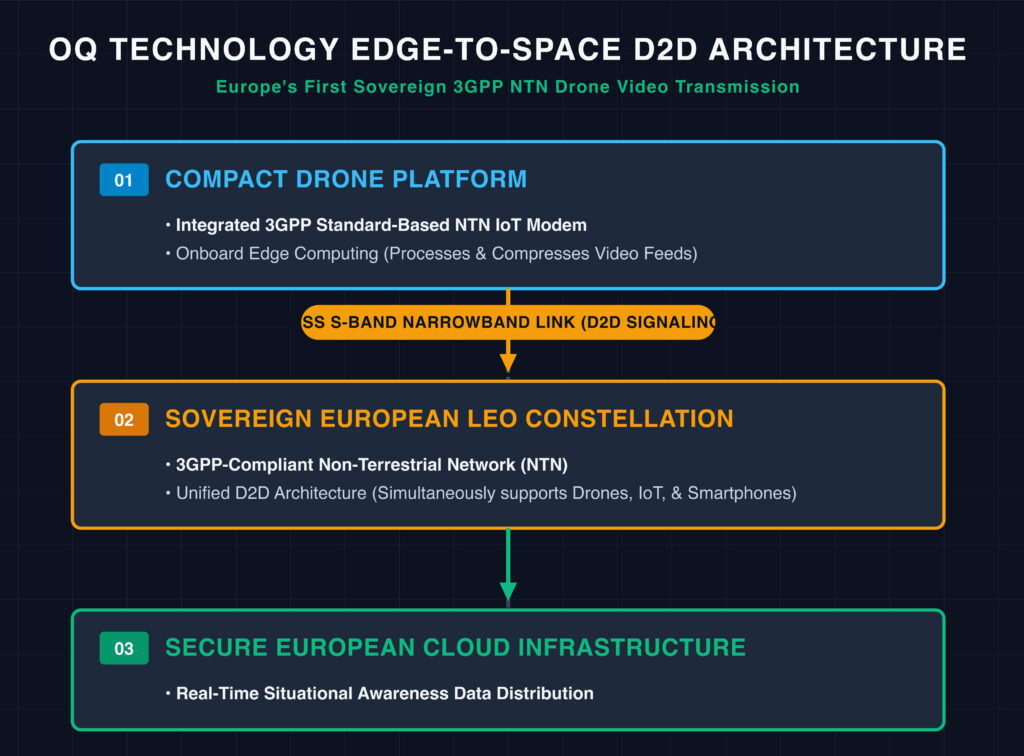
LUXEMBOURG — June 24, 2026 — OQ Technology, operating as the world’s first 5G Non-Terrestrial Network (NTN) operator and a pioneer in Direct-to-Device (D2D) satellite connectivity, has announced the successful completion of Europe’s first drone video transmission over a Low Earth Orbit (LEO) satellite network.

The milestone transmission was achieved using standardized 3GPP NTN technology and Mobile Satellite Services (MSS) S-band spectrum.

The live demonstration routed video from a compact drone through OQ Technology’s sovereign European satellite constellation and a secure cloud network based in Europe. A video demonstration of the capability has been made available by the company online.

Ditching Bulky VSAT: How Edge-to-Space Integration Works

Historically, streaming live video from autonomous aerial platforms required bulky, expensive, and power-hungry VSAT or broadband satellite hardware mounted directly to the airframe. OQ Technology’s approach sidesteps these physical and financial constraints by shifting processing to the edge.

The system integrates a compact, standard-based 3GPP NTN IoT modem directly into the lightweight drone architecture. Video data is fully processed and compressed via onboard edge computing before being efficiently transmitted over a narrowband satellite uplink. This design dramatically reduces the size, weight, power consumption, and overall deployment costs associated with aerial satellite relays.

Crucially, the demonstration was executed entirely over OQ’s active LEO network, validating a unified ecosystem where drones, specialized IoT hardware, and off-the-shelf consumer smartphones—including models from Apple, Google, and Samsung—can seamlessly communicate across a single, standardized 3GPP-compliant infrastructure.

Strategic Autonomy and Mission-Critical Applications

The tactical validation highlighted three practical operational use cases for satellite-connected unmanned aerial vehicles (UAVs):

  • Infrastructure Monitoring: Inspecting industrial assets in highly isolated or unserviced environments.
  • Traffic Surveillance: Providing highway and logistical route oversight beyond the reach of terrestrial base stations.
  • Autonomous Guidance: Executing long-range drone guidance toward a designated destination using space-based telemetry links.

Beyond commercial applications, the technology provides critical situational awareness for civilian, governmental, and enterprise teams navigating disconnected or disaster-affected zones. Potential crisis applications include disaster response coordination during severe floods and wildfires, maritime and border surveillance, and environmental tracking.

“This achievement demonstrates the growing maturity and strategic importance of standardized 3GPP NTN technology for Europe,” said Omar Qaise, Founder and CEO of OQ Technology. “For the first time, we have demonstrated drone video transmission through a European direct-to-device LEO satellite network using compact hardware and MSS S-band spectrum rather than large satellite terminals. This opens entirely new possibilities for emergency response, infrastructure monitoring, maritime awareness, border surveillance, public safety, and other mission-critical operations where terrestrial networks are unavailable.”

The technical success directly bolsters Europe’s ongoing geopolitical push for secure, resilient, and fully sovereign communications infrastructure under dedicated space initiatives like IRIS² and the European Union’s broader strategic autonomy agenda. By demonstrating that even the smallest connected devices can maintain real-time space links without proprietary hardware overhauls, OQ Technology has established a vital template for the next generation of global non-terrestrial connectivity.

Filed Under: Uncategorized

Analyst Projects Massive Subscription Growth for Starlink Ahead of Imminent SpaceX IPO

June 5, 2026 by donmcgee

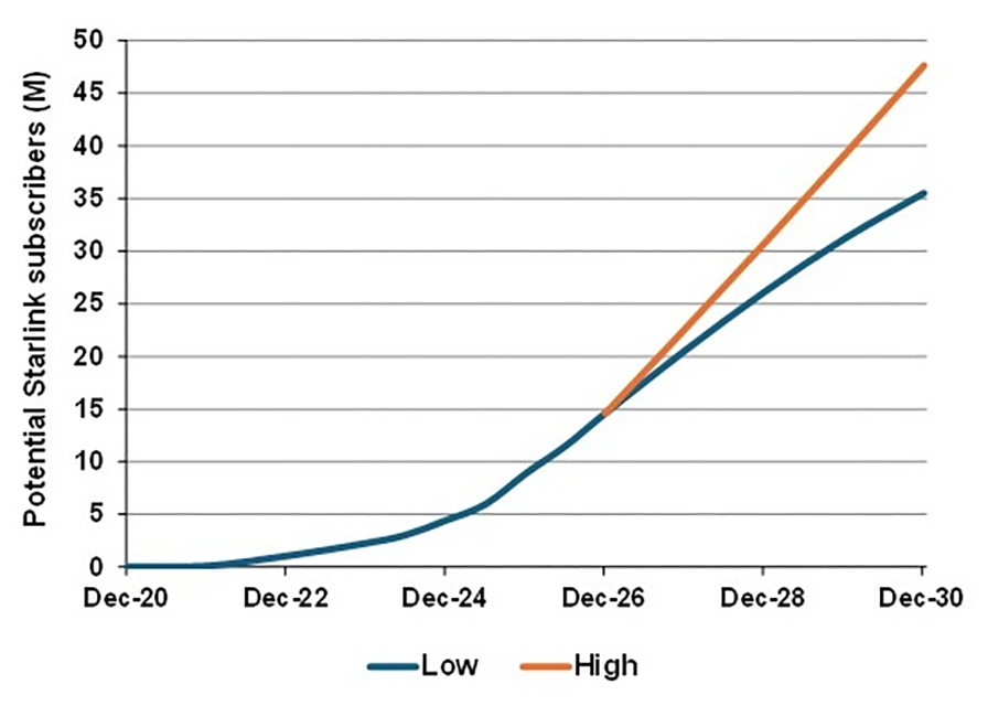
Professor Tim Farrar of TMF Associates has released a comprehensive new analysis detailing the consumer business prospects for Starlink. Published on June 5, 2026, the report arrives at a critical juncture for the commercial space sector as the industry braces for the highly anticipated SpaceX initial public offering.

The deep dive provides the first detailed geographical breakdown of Starlink’s global customer distribution, utilizing meticulous weekly monitoring of active satellite terminals to project future subscriber bases and revenues across various countries and regions.

Historic Growth and Future Trajectory

The historical data presented in the report summary illustrates a staggering pace of customer acquisition. Starlink’s global subscriber count has experienced explosive year-over-year growth, climbing from 2.3 million in 2023 to 4.4 million in 2024. The network then doubled again to reach 8.9 million users in 2025. As of the end of the first quarter in March 2026, the active subscriber base has surged to 10.3 million users.

Looking forward, the report’s headline forecast suggests that this momentum is far from slowing down. Farrar outlines a “Bull case” scenario in which Starlink could capture more than 45 million subscribers by the year 2030. Even the more pessimistic “Bear case” projection estimates that the satellite internet provider will secure a massive customer count exceeding 35 million by the end of the decade. Analysts note that Starlink may even target a doubling of its subscriber base to reach 18 million global users by the end of 2026.

Navigating Terrestrial Competition and Capacity Limits

Despite the bullish projections, the report carefully outlines the potential limitations to Starlink’s future growth. A primary challenge will be how successfully the satellite operator can compete against established terrestrial alternatives in densely populated or highly developed countries. To maintain its rapid cadence of growth, particularly in mature markets like the United States, Starlink will need to increasingly capture market share from traditional telecommunications and cable internet providers, potentially utilizing aggressive pricing strategies as a lever to attract new consumer demographics.

Furthermore, the physical limitations of orbital infrastructure remain a crucial factor. Starlink currently possesses a network capacity capable of supporting approximately 20 million broadband subscribers. Scaling beyond this threshold to reach the 40 million mark will necessitate the continued mass deployment of V2 Mini satellites utilizing the Falcon 9 launch vehicle, alongside the successful introduction of next-generation hardware architectures.

Assessing the Threat from Amazon LEO

The analysis also dedicates significant attention to the looming competitive threat posed by Amazon’s Low Earth Orbit constellation. By comparing the underlying technologies and deployment timelines of both networks, the report assesses whether there is any realistic prospect of Amazon making significant inroads into Starlink’s market dominance in the coming years.

While Amazon possesses a formidable retail presence and vast financial resources, its initial constellation of 700 satellites is projected to only support around 1.5 million broadband subscribers. This stark contrast in immediate network capacity suggests that Starlink will likely maintain a comfortable lead in subscriber acquisition, forcing emerging competitors to aggressively scale their launch cadences and orbital infrastructure if they hope to capture a meaningful share of the booming satellite broadband market.

Filed Under: Featured, Uncategorized

  • « Go to Previous Page
  • Page 1
  • Interim pages omitted …
  • Page 18
  • Page 19
  • Page 20
  • Page 21
  • Page 22
  • Interim pages omitted …
  • Page 27
  • Go to Next Page »

Primary Sidebar

WEEKLY NEWSLETTER

Archives

  • November 2026
  • October 2026
  • September 2026
  • August 2026
  • July 2026
  • June 2026
  • May 2026
  • April 2026
  • March 2026
  • February 2026
  • January 2026
  • December 2025
  • November 2025
  • October 2025
  • September 2025
  • August 2025
  • July 2025
  • June 2025
  • May 2025
  • April 2025
  • March 2025
  • February 2025
  • January 2025
  • December 2024
  • November 2024
  • October 2024
  • September 2024
  • August 2024
  • July 2024
  • June 2024
  • May 2024
  • April 2024
  • March 2024
  • February 2024
  • January 2024
  • December 2023
  • November 2023
  • October 2023
  • September 2023
  • August 2023
  • July 2023
  • June 2023
  • May 2023
  • April 2023
  • March 2023
  • February 2023
  • January 2023
  • December 2022
  • November 2022
  • October 2022
  • September 2022
  • August 2022
  • July 2022
  • June 2022
  • May 2022
  • April 2022
  • March 2022
  • February 2022
  • January 2022
  • December 2021
  • November 2021
  • October 2021
  • September 2021
  • August 2021
  • July 2021
  • June 2021
  • May 2021
  • April 2021
  • March 2021
  • February 2021
  • January 2021
  • December 2020
  • November 2020
  • October 2020
  • September 2020
  • August 2020
  • July 2020
  • June 2020
  • May 2020
  • April 2020
  • March 2020
  • February 2020
  • January 2020
  • December 2019
  • November 2019
  • October 2019

© 2019–2026 SatNews

Insert/edit link

Enter the destination URL

Or link to existing content

    No search term specified. Showing recent items. Search or use up and down arrow keys to select an item.
      x
      Sign Up Now!

      Enjoy a free weekly newsletter with recent headlines from the global SmallSat industry.

      Invalid email address
      We promise not to spam you. You can unsubscribe at any time.
      Thanks for subscribing! You will now receive weekly SmallSat News updates.
      We love our advertisers.
      And you will too!

      Please disable Ad Blocker to continue... We promise to keep it unobtrusive.
      We promise not to spam you. You can unsubscribe at any time.
      Invalid email address
      Thanks for subscribing!